Grande traversée Alpi Marittime
19 steps
21 points of interest
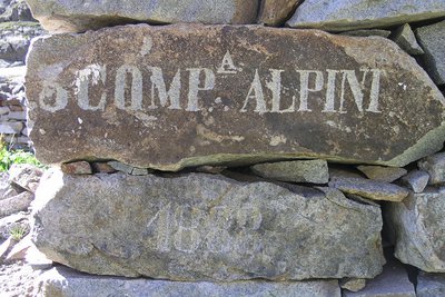
Iscrizione su un cantonale di un ricovero ottocentesco al Lago inferiore di Valscura - Roberto Pockaj  History and historical trail
The Valscura Barracks
Since the end of the eighteen hundreds(an inscription on the remains of a shelter reads "3° Compagnia Alpini, 1888") Lower Lake Valscura was chosen as the site where troops were garrisoned to defend the strategic pass of Bassa del Druos. Beginning in 1888, when barracks were erected to house 140 soldiers and two officers, for almost fifty years buildings were constructed on this site, until the entire complex was finally transformed into an armory, officially known as A131,containing munitions, explosives and artillery pieces.
Il Lariceto - Cati Caballo  Flora
FloraThe larch
This type of forest is rather localized in the Maritime Alps, which notoriously represent the realm of the beech forest. It covers the slopes at the heads of the valleys with sparse and luminous populations, sometimes grazed by the herds that have climbed the mountain pastures. Most of the time their purity is not natural, but induced by man: in fact, over the centuries, man has favored this tree species to the detriment of others, such as the stone pine, for example, because they are less favorable for exercising the grazing due to the increased shading of the soil.
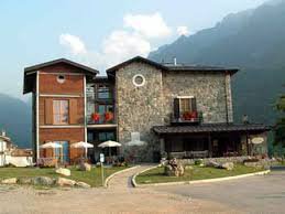
L'Hotel Royal a Terme di Valdieri - Roberto Pockaj  Architecture
The Valdieri Royal Hot Springs
First cited in the mid sixteenth century. When King Carlo Emanuele III decided to valorize the Valdieri hot springs, in 1755, a building and other appurtenances were quickly built in order to create a spa around the sulfurous waters. Cavour called Valdieri "the richest in health-preserving waters in all the nation, and perhaps in all of Europe as well". Vittorio Emanuele II, who first visited Val Gesso in 1855, became a frequent guest at the spa, and it was at his behest that, on 10 July 1857, the first stone was laid for the structure that was to become the Hotel Royal.
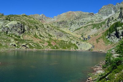
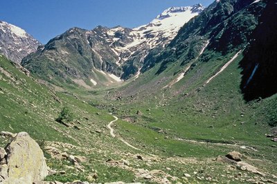
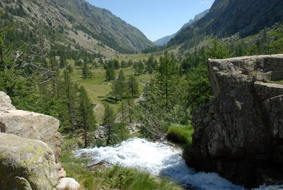
Panorama dai pressi del Lagarot di Lourousa; sullo sfondo al centro il Canalone di Lourousa e, a destra, il Corno Stella - Roberto Pockaj  Lake
LakeThe Lagarot di Lourousa
Springwater, welling up among meadows and larches, forms numerous limpid pools and streams; the water is at times turquoise, at times milky and at others perfectly transparent, making this a particularly striking location, perfect for a contemplative rest. The Canalone di Lourousa, bordered by Monte Stella and the Corno Stella and scoured by the Gelas di Lourousa, lies beyond the plateau of the same name, and a look over one's shoulder yields a view of the imposing outline of Monte Matto.

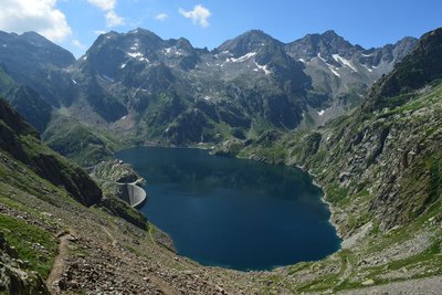
La diga del Chiotas - Roberto Pockaj LakeThe Chiotas Reservoir, the Della Piastra dam and the Lake della Rovina
The Chiotas Reservoir is closed off by two dams: the Chiotas dam and the Colle di Laura dam. The Chiotas dam, an arch-gravity structure, is 130 meters high and stretches for a length of 230 meters. Its thickness varies from 37.5 meters at its base to 5 meters at the top. The mass gravity Colle di Laura dam is smaller, rectilinear and only 30 meters at its maximum height. Its length is 70 meters. The Chiotas Reservoir has a carrying capacity of 27.3 million cubic meters of water.
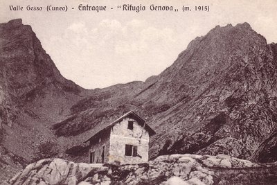
Il vecchio Rifugio Genova - Archivio EAM ArchitectureThe Genova Figari Refuge
To valorize the hiking trails along the Argentera Massif, in the last years of the nineteenth century the Liguria chapter of CAI decided to build a refuge near the upper Gias del Monighet, in the Vallone della Rovina. The Genova Refuge, as it was named, was inaugurated on 15 August 1898.
But the fate of the first refuge in the Maritime Alps was definitively sealed in 1968: the reservoir of the new Chiotas dam would submerge it permanently. ENEL assumed the task of building another refuge, which was inaugurated in 1981.
The refuge is named for Bartolomeo Figari, who as Secretary General of CAI saw both the successful conquest of K2 and the birth of the National Alpine Rescue Corps, to which he bequeathed all his worldly goods.
Praterie di alta quota - Cati Caballo FloraThe cleared meadows
At the highest altitudes there are cleared meadows, the typical alpine pastures; they are composed of herbaceous species capable of covering soils normally closed to woody species, which, due to the very short vegetative period, cannot find suitable conditions for their development. Grazing by wild ungulates and, sometimes, by domestic sheep affects their composition, even if the most severe factor for species selection is represented by the climate.
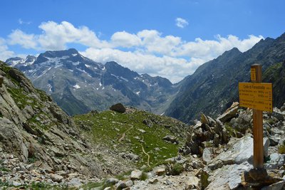
Giovani stambecchi al Colle di Fenestrelle - Roberto Pockaj  FaunaColle di Fenestrelle, as well as the surrounding area, is very popular with the ibex.
The Alpine ibex (Capra ibex), frequents alpine meadows and rock faces even above 3000 m, reaching the valley floor (provided it is not wooded) only in early spring, to be able to refresh itself after the long winter. Both sexes have annual growth horns, but much larger in males. The coat, light beige in summer, darkens to dark brown in winter.
Sedentary, grazing, it essentially feeds on grass, integrated with mosses, lichens and leaves of mountain shrubs, especially in winter.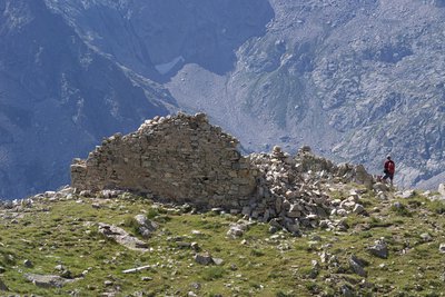
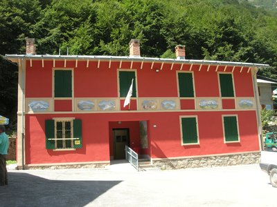
Il Ricovero Fenestrelle - Roberto Pockaj History and historical trailThe Fenestrelle shelter
The ruins near the pass mark the site of the Fenestrelle shelter, named for Lieutenant Angelo Bertolotti. Built in 1888 and in use until the Second World War, it could house a garrison of 10 on straw pallets. In their guidebook, entitled "La Valle Gesso", the Boggias indicate the shelter as being instead dedicated "to the memory of Angelo Bortolo, of the 1∞ Reg. of the Alpine Corps, who was killed on the Ortigara during the First World War".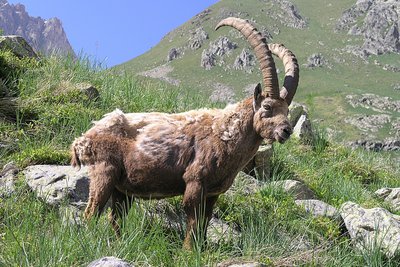
Stambecco maschio adulto, durante la muta primaverile del mantello - Roberto Pockaj FaunaThe Ibex of the Alps
Colle di Fenestrelle, as well as the surrounding area, is very popular with the ibex.
The Alpine ibex (Capra ibex), frequents alpine meadows and rock faces even above 3000 m, reaching the valley floor (provided it is not wooded) only in early spring, to be able to refresh itself after the long winter. Both sexes have annual growth horns, but much larger in males. The coat, light beige in summer, darkens to dark brown in winter.
Sedentary, grazing, it essentially feeds on grass, integrated with mosses, lichens and leaves of mountain shrubs, especially in winter.
I resti di una cucina da campo nei pressi del Piazzale dei Cannoni - Roberto Pockaj History and historical trailThe Piazzale dei Cannoni
The name Piazzale dei Cannoni, or better still, Piana dei Cannoni, is due to the presence there of the 181st Artillery Battery, armed with 210/8 mortars, during the Second World War. The mortar emplacements are just south of the dirt road, along the slope, but they are not easy to spot. On the opposite side of the valley, across the torrent, there are the remains of probable logistical outposts and even an open-air kitchen.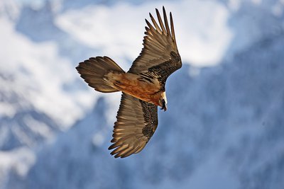
Un gipeto in volo - Michelangelo Giordano FaunaThe bearded vulture
The bearded vulture (Gypaetus barbatus), also known as the lamb vulture, has a wingspan that can reach 285cm and can weigh more than 6 kilos. An accomplished glider, it can exploit even the mildest ascending thermals. It is a carrion eater, feeding exclusively on carcasses of dead animals, ungulates for the most part, both wild and domestic. It consumes bones, cartilage and ligaments, and is known to drop bones from great heights in order to break them into manageable pieces. Monogamous and long-lived, the bearded vulture nests on rocky cliff faces at altitudes beween 1,000 and 3,000 meters.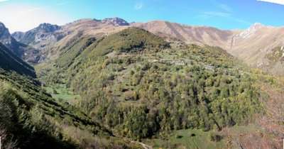
Il bosco bandito che protegge Palanfre - gianluca.giordano History and historical trailThe Banned Wood of Palanfrè
The town of Palanfrè is located at the foot of the steep pasture slopes of Costa Pianard, in a very risky position due to the fall of avalanches. To protect the town, since the early 18th century but probably also earlier, the cutting of the beech forest upstream of the houses had been banned (the "Bandi Campestri" in the archives of the municipality of Vernante, dated 1741, are the first written testimony of the state of protection of the forest). Since 1979, the beech forest has been part of the Palanfrè Woods and Lakes Nature Reserve and was then merged, in 1995, into the Maritime Alps Natural Park. The forest, of over 20 hectares, is only touched by the path: despite this, it is possible to admire the majesty of some of its trees.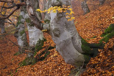
Faggi secolari nel bosco bandito di Palanfrè - Roberto Pockaj FloraThe Beech
The beech (Fagus sylvatica), a splendid tree with a gray and smooth bark and oval, intense green leaves, is often present in popular narratives as a magical tree inhabited by gnomes. It prefers shady slopes, up to 1800m above sea level, and can live over 300 years. It produces excellent wood, used for making barrels, tool handles and as fuel. The fruits, the beechnuts, are used as fodder for the pigs.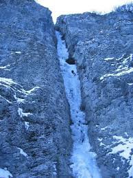
La cascata di Pioccia - gianluca.giordano  Glacier
The snowfield of Pioccia
At the bottom of the valley is the perennial snowfield at the lowest altitude of all the Maritime and Ligurian Alps, fed by the numerous avalanches that descend along the watersheds of the Vallone di Pioccia. In past times it was a source of supply for blocks of ice which, transported downstream, were used in the cold rooms.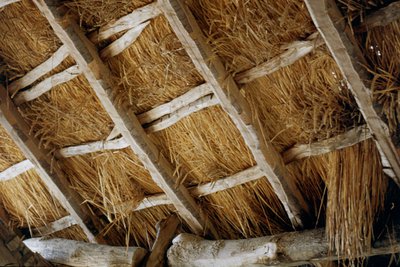
I tetti in paglia di segale - Roberto Pockaj  Know-how
The rye thatched roofs
Typical of valleys lacking schistose rocks, that is easily split into slabs (lose), the roofing in rye straw was particularly widespread in all the Monregalese valleys, in Val Vermenagna and in Valle Stura. The stems were grouped in bundles and fixed to the roof framework to create fairly durable and highly insulating covers. The pitches of the roof were much more sloping than those of the roofs made of slate, since the light framework could not have supported the weight of large accumulations of snow.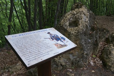
Le Roccette di Napoleone - Roberto Pockaj History and historical trailLe Roccette di Napoleone
The story speaks of a clash that took place on 8 August 1794 in this locality, then known as Pianot dell'Arp. The French troops, under the command of General Bonnau, descended into the valley from Colle Arpiola and from the Passo del Bec Baral, and fought with the Austro-Piedmontese troops under the command of General Audezeno. The Piedmontese retreated as far as the slopes of Monte Sapè, then, helped by the local population, repulsed the assault.
Two (perhaps three) crosses are engraved on the rocks that emerge from the ground here in memory of the fifteen soldiers who lost their lives and were buried here.
La Cava di Bec Moler - Roberto Pockaj Know-howThe Bec Moler Quarry
The Bec Moler quarry, used as a silica quarry for the Vernante glassworks, was cultivated until the 1960s, when it was abandoned in favor of more profitable quarries in the municipality of Robilante. The main access gallery is still passable and allows you to observe the quarry from above.
Before mining began, the millstones (or grindstones) for the mills were obtained from the Bec Moler, a fact which explains the toponym of the mountain. With a bit of attention it is still possible to observe on the rocky walls the circular carvings from which the millstones were extracted. The extraction was not always successful, as evidenced by a millstone which broke during the extraction phase and is still partly attached to the parent rock.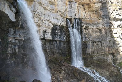
Il Pis del Pesio - Roberto Pockaj  Geology
The Pis del Pesio and the karst system of the Conca delle Carsene
The karst system of "Conca delle Carsene - Pis del Pesio" is the second most important in the area of the Ligurian Alps. The waters collected on the southern slope of the Marguareis massif (Conca delle Carsene and Conca di Plan Ambreuge), orographically destined for the Tyrrhenian Sea, infiltrate the ground and flow into the resurgence of the Pis del Pesio; from here, across the Po, they reach the Adriatic Sea.
La Conca delle Carsene - Archivio EAM GeologyLa Conca delle Cársene
The Conca delle Càrsene is a vast plateau consisting of limestone rocks, characterized by expanses of bare, white rocks alternating with grassy cover.
It manifests the typical aspects of karst areas with limestone pavement, dolines and sinkholes. A superficial hydrographic network is completely missing: rain and snow meltwater are immediately absorbed and give rise to the resurgence of Pis del Pesio, located several hundred metres below.
Curiously, there are also areas located beyond the Alpine watershed, such as Plan Ambreuge, that are part of the catchment area, so water falling south of the Alps, after an underground journey, flow out on the Italian side.[Alpi Liguri, p.80]
[La Guida del Parco Alta Valle Pesio e Tanaro, pp.46-47]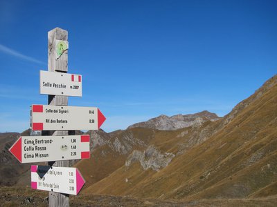
Palina segnaletica al Colle delle Selle Vecchie - Archivio EAM  Cross-border
The Colle delle Selle Vecchie
This was an important pass in past ages, probably on one of the salt routes, it was widely used by the shepherds from Briga in their transhumance towards the pastures at the foot of the Marguareis Massif.
The place name refers to the "selle", or "cellars" for the preservation of cheeses, once evidently present in the surrounding area. The cellars are generally stone buildings, with a barrel vault, covered and insulated with grass clods to ensure constant temperature and humidity inside.
[A. Parodi, R. Pockaj, A. Costa - Nel cuore delle Alpi Liguri, collana Sentieri e Rifugi, Andrea Parodi Editore, 2012, p.34]
Altimetric profile
Report a problem or an error
If you have found an error on this page or if you have noticed any problems during your hike, please report them to us here:
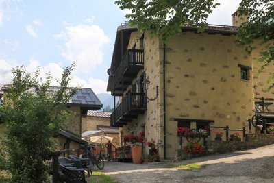
Close by11
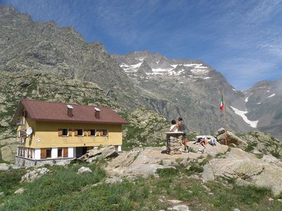
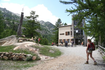
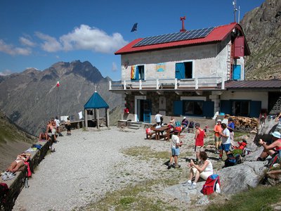
- Mountain Hut
Mountain Hut
Rifugio Morelli - Buzzi 2351 m
The Morelli-Buzzi Mountain Hut was built by the CAI (Italian Alpine Club) of Cuneo in 1931, expanded in 2000, and completely renovated in three phases between 2010 and 2012.
It is located in the enchanting Lourousa Valley, in the heart of the Maritime Alps Regional Nature Park, at the foot of the north face of Monte Stella. - Mountain Hut
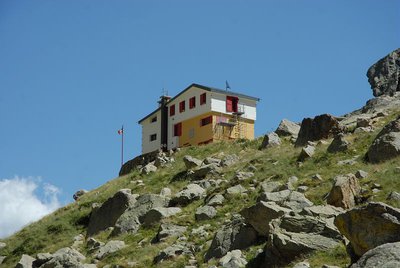
Mountain Hut
Rifugio escursionistico S. Giacomo e Baita Monte Gelas 1226 m
The Monte Gelas Mountain Hut was founded in 1953 by Giovanni Gerbino and Caterina Mellano. Since then, the Gerbino family has been offering hospitality and refreshments to visitors to the upper Gesso Valley, while also managing the adjacent San Giacomo Hiking Hut.