GTAM - Stage 11 : Palanfrè - Agriturismo l'Agrifoglio
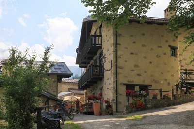
Vernante
11. GTAM - Stage 11 : Palanfrè - Agriturismo l'Agrifoglio
Hard
6h30
18,5km
+1088m
-1508m
Longer treks
Embed this item to access it offline
This long stage opens a window on traditional alpine architecture and the life of mountain people. Unfortunately, most of the hamlets crossed are often in ruins, while the characteristic rye straw roofs have often disappeared...
4 points of interest
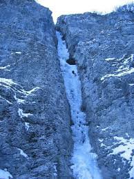
La cascata di Pioccia - gianluca.giordano  Glacier
The snowfield of Pioccia
At the bottom of the valley is the perennial snowfield at the lowest altitude of all the Maritime and Ligurian Alps, fed by the numerous avalanches that descend along the watersheds of the Vallone di Pioccia. In past times it was a source of supply for blocks of ice which, transported downstream, were used in the cold rooms.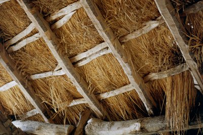
I tetti in paglia di segale - Roberto Pockaj  Know-how
The rye thatched roofs
Typical of valleys lacking schistose rocks, that is easily split into slabs (lose), the roofing in rye straw was particularly widespread in all the Monregalese valleys, in Val Vermenagna and in Valle Stura. The stems were grouped in bundles and fixed to the roof framework to create fairly durable and highly insulating covers. The pitches of the roof were much more sloping than those of the roofs made of slate, since the light framework could not have supported the weight of large accumulations of snow.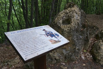
Le Roccette di Napoleone - Roberto Pockaj  History and historical trail
Le Roccette di Napoleone
The story speaks of a clash that took place on 8 August 1794 in this locality, then known as Pianot dell'Arp. The French troops, under the command of General Bonnau, descended into the valley from Colle Arpiola and from the Passo del Bec Baral, and fought with the Austro-Piedmontese troops under the command of General Audezeno. The Piedmontese retreated as far as the slopes of Monte Sapè, then, helped by the local population, repulsed the assault.
Two (perhaps three) crosses are engraved on the rocks that emerge from the ground here in memory of the fifteen soldiers who lost their lives and were buried here.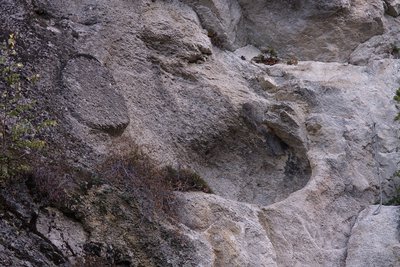
La Cava di Bec Moler - Roberto Pockaj Know-howThe Bec Moler Quarry
The Bec Moler quarry, used as a silica quarry for the Vernante glassworks, was cultivated until the 1960s, when it was abandoned in favor of more profitable quarries in the municipality of Robilante. The main access gallery is still passable and allows you to observe the quarry from above.
Before mining began, the millstones (or grindstones) for the mills were obtained from the Bec Moler, a fact which explains the toponym of the mountain. With a bit of attention it is still possible to observe on the rocky walls the circular carvings from which the millstones were extracted. The extraction was not always successful, as evidenced by a millstone which broke during the extraction phase and is still partly attached to the parent rock.
Description
From the village of Palanfrè (1379 m) go down to the paved car park below. At the end of the car park follow a dirt track, then take the path to the left for Vernante.
After leaving the pastures, a traverse and steep beechwood hairpin bends lead to the collar of the seat of the Tetti Cucet.
Cross the Vallone di Franco, then enter the narrow Vallone di Pioccia.
You go through three steep ravines in succession, then, with the help of a few metal steps fixed on the rocks, you look at the stream in the main stream of the valley.
On the opposite side the path reaches Tetti Doni (1484 m, 1:50 hours from Palanfrè), then crosses two successive valleys, in the second of which you will find Tetti Bertaina.
A steep descent leads first to Tetti David, then to the modest Intaglio della Bercia. Returning to the woods, with a nice flat track you reach Tetti Colletta (1226 m, 0:50 hours from Tetti Doni).
You reach the dirt road at the service of the village, descending to the first hairpin bend. Take the path on the left that leads to the ridge between Vallon Secco and Val Grande and loses altitude in the beech forest.
The descent then leads to an obvious crossroads, where you turn right onto the steep dirt track.
Once in front of the entrance of a disused silica quarry, turn right again, descending to the paved road below.
Turn left until you reach the historic centre of Vernante (790 m, 1:10 hours from Tetti Colletta).
From corso Umberto I turn left into via Mistral as far as the junction for Tetti Cesa. Between the two paved roads, there is the path to Limone Piemonte.
Climb uphill to the Tetti Cesa, where you will find a dirt road.
At the first hairpin bend to the left, take the path in front, which crosses a ridge and leads onto a mule track.
Continue to the right, in the Salet Valley: the mule track loses altitude and you enter a forest track, go to the right and, crossed a stream on a bridge, take the path to the left.
Take a mule track and go to the right: after a stream, at the first fork, keep to the left.
Go uphill past the ridge that leads to the Vallone di Santa Lucia (on the ridge you ignore the path on the left) and, continuing forward, you reach the Tola Roofs.
Pass in succession two streams, the first on a bridge, the second ford, and you reach a paved road, which you follow to the right. The road skirts the Rulin Roofs (986 m, 1:15 hours from Vernante) and quickly loses altitude. Take the marked path on the left which, flat, touches the ruins of Tetti Pulenta and leads to a dirt road. Go left as far as the Riss Roofs (fountain).
Continue on the path and you will reach a dirt track, which you follow on the left as far as the Cabila Adreit roofs (990 m, 0:20 hours from the Rulin roofs, fountain). Walk uphill around the houses then, after a stream and a few ruins, with a sharp surge you get to the ruins of Tetti Buter.
Cross an unnamed collar and enter Vallone Ceresole. The path cuts downhill into the woods, then through meadows, and reaches the nearby paved road, which you follow to the right to Agriturismo l'Agrifoglio.
- Departure : Palanfrè
- Arrival : Agriturismo l'Agrifoglio
- Towns crossed : Vernante and Limone Piemonte
Altimetric profile
Report a problem or an error
If you have found an error on this page or if you have noticed any problems during your hike, please report them to us here: