The 4 valley circuit - Stura - Maira - Haute Tinée - Ubaye
5 steps
5 points of interest
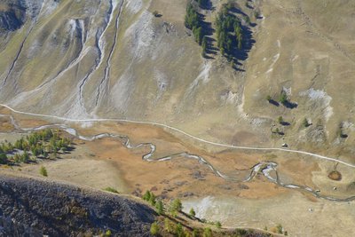
Sur le replat de Val Fourane, au niveau de la cabane Tardiez, l’Ubayette serpente tranquillement au milieu d’une zone humide. - François BRETON  Flora
FloraThe Tardieu hut prairies
The prairies which surround the Tardieu hut are called “tall-festuca grassland”. This name comes from the dominant plant species, a tall kind of grass which grow in tall, tough clumps. The list of plants which grow alongside this tall grass and form the combination of plants constituting tall-festuca areas is long, but one of the jewels in the crown is surely Alpine sea holly or Queen of the Alps with metallic blue shades. This is currently the last area with Alpine sea holly in Ubaye, the department and the National Park.
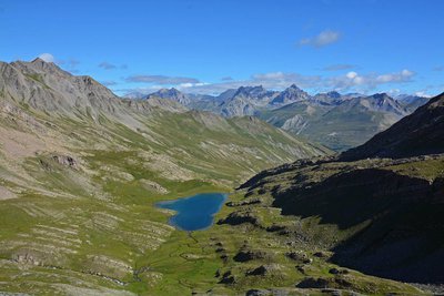
Le lac du Lauzanier dans l'Ubayette à Larche - BRETON François  Lake
LakeThe wetland zone
From the pastoral hut at Tardieu, the track, which is horizontal at this point, overlooks the great plateau where the winding Ubayette sparkles.
A few thousand years ago, you would not have had to go much further to find a deep lake. This great flat area with its tender green hues was covered by a lake, which was hollowed out by the Lauzanier glacier. It was not very deep and was filled in by the deposits which came off the brittle slopes.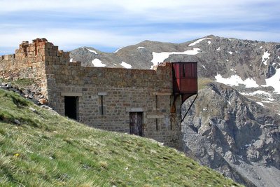
Le fort du Camp des Fourches avec sa tourelle métallique dite « Séré de Rivière ». - Anthony TURPAUD  History and historical trail
Removal zones
The depression on your right was one of the zones from where material was removed from to build Camp des Fourches at the start of the last century. The former military dry-stone track allows you to reach Cime de Pelousette.

 Architecture
The fountain
After a climb, often in the sunshine, a refreshing break at the fountain is very welcome.
The water emerging from the ground is very cool and provides you with the chance to take a break before continuing your climb or to have a drink before returning into the heat of the valley.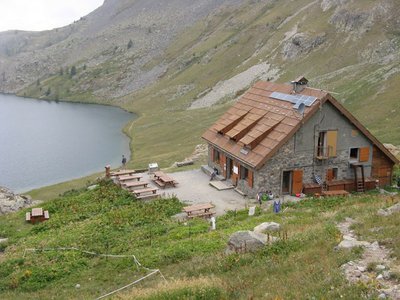
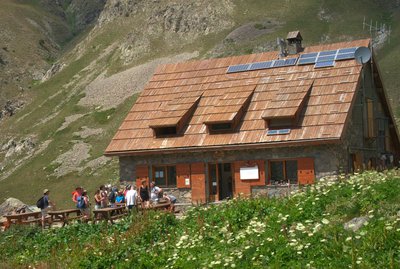
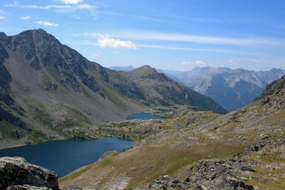
Refuge de Vens - CAF / DR  Refuge
Lac de Vens and refuge
The Vens refuge only has a warden during the summer months. In winter, only one room is open to allow hikers to shelter. The Vens refuge overlooks a series of lakes of the same name. These lakes are of glacial origin, they are the result of a long erosion process by glaciers. The lake below the refuge (the biggest) is 31 metres deep. Ibex, chamois, mouflons and golden eagles can often be seen at the site. Very close to the refuge, you can see the endemic plant which was for a long time the symbol of the Mercantour National Park: Saxifraga florulenta.
Club Alpin Français: Capacity: 45 in summer and 30 in winter (no warden)
Reservations only be e-mail in summer: http://refugedevens.ffcam.fr/reservation.html
No shower, meal included
Altimetric profile
Recommandations
Specific regulations concerning protected species in Mercantour National Park.
This itinerary takes place along high-valley Alpine paths.
The accommodation sites listed are the only ones which are available along this route. Before heading off on a hike, ensure that you have studied the safety advice. If you are setting off on this hike in the early part of the season, you will need to take particular care as patches of snow can still be present in higher areas.Access and parking
Report a problem or an error
If you have found an error on this page or if you have noticed any problems during your hike, please report them to us here:
Close by2
- Mountain Hut