5. The 4 valleys circuit - Stura - Maira - Haute Tinée - Ubaye - Stage 5
1 point of interest
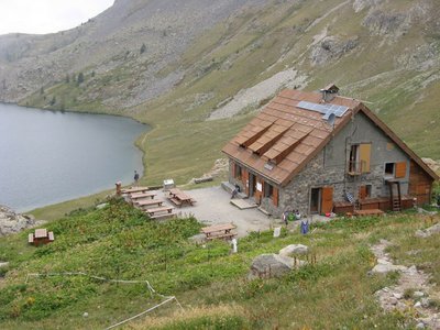
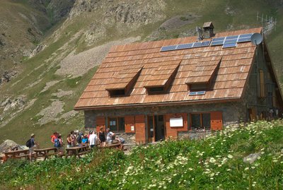
Refuge de Vens - CAF / DR  Refuge
Lac de Vens and refuge
The Vens refuge only has a warden during the summer months. In winter, only one room is open to allow hikers to shelter. The Vens refuge overlooks a series of lakes of the same name. These lakes are of glacial origin, they are the result of a long erosion process by glaciers. The lake below the refuge (the biggest) is 31 metres deep. Ibex, chamois, mouflons and golden eagles can often be seen at the site. Very close to the refuge, you can see the endemic plant which was for a long time the symbol of the Mercantour National Park: Saxifraga florulenta.
Club Alpin Français: Capacity: 45 in summer and 30 in winter (no warden)
Reservations only be e-mail in summer: http://refugedevens.ffcam.fr/reservation.html
No shower, meal included
Description
From the Vens refuge, head past markers 25 and 24 as you go towards the secondary summit of Tortisse 2591m and its characteristic arch marker 35a. Take a right fork to follow a path through the through the shale and stones until Pas de la Blanche, which is on the border ridge and has a magnificent view over the Vens lakes far below.
The path runs along the ridge, leading you to Col di Panieris at 2683m altitude. A signpost indicates the way to: Vallon de Pontebernardo – Refuge Talarico Longue and there is a descent via a series of hairpins across screes to reach the hamlet of Prati del Vallone and the Talarico refuge. From the carpark as you leave the hamlet, take the track for the Pontebernardo valley; the track becomes a road as you draw near to the village.- Departure : Vens refuge
- Arrival : Pontebernardo
- Towns crossed : Saint-Étienne-de-Tinée, Argentera, and Pietraporzio
Altimetric profile
Report a problem or an error
If you have found an error on this page or if you have noticed any problems during your hike, please report them to us here:
Close by1
- Mountain Hut