4. The 4 valleys circuit - Stura - Maira - Haute Tinée - Ubaye - Stage 4
2 points of interest

 Architecture
The fountain
After a climb, often in the sunshine, a refreshing break at the fountain is very welcome.
The water emerging from the ground is very cool and provides you with the chance to take a break before continuing your climb or to have a drink before returning into the heat of the valley.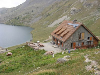
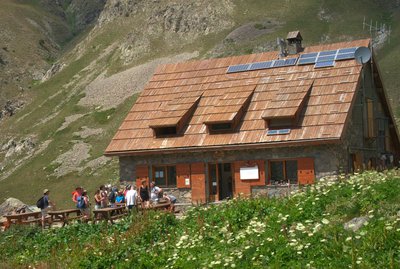
Refuge de Vens - CAF / DR  Refuge
Lac de Vens and refuge
The Vens refuge only has a warden during the summer months. In winter, only one room is open to allow hikers to shelter. The Vens refuge overlooks a series of lakes of the same name. These lakes are of glacial origin, they are the result of a long erosion process by glaciers. The lake below the refuge (the biggest) is 31 metres deep. Ibex, chamois, mouflons and golden eagles can often be seen at the site. Very close to the refuge, you can see the endemic plant which was for a long time the symbol of the Mercantour National Park: Saxifraga florulenta.
Club Alpin Français: Capacity: 45 in summer and 30 in winter (no warden)
Reservations only be e-mail in summer: http://refugedevens.ffcam.fr/reservation.html
No shower, meal included
Description
From Bousiéyas, take the D64 downhill for around 2km towards Saint-Etienne-de-Tinée, and reach the hamlet of Pra (1700 m - m32). The path begins on your left, 300m after having crossed the bridge over the Salso Moreno valley. It has clear marker with a yellow rectangle and it initially climbs along hairpin bends on the rocky southern slope which overlooks the road before reaching the verdant Morgon plateau (footbridge). The itinerary crosses the prairie, heading over a secondary summit (b33), before heading downhill for few metres towards the Tortisse valley and, via a long uphill section which passes over the mountain stream, reaching the Tortisse plateau and forest houses. (2252m). At marker 34, turn left and head slightly uphill towards the Tortisse mountain stream, which you will need to ford and then rise along a good path opposite the worn away stacks until you reach the grasses of the Col du Fer (2584m - b35). When the weather is fine, there is a magnificent panorama over the Mercantour and Italy.
Continue along the path with signposts for the Vens refuge via an uphill section which leads to the wide secondary summit of Tortisse (2591m - b35a), at the foot of the stacks of Tortisse. Shortly after having begun the descent, you will suddenly be able to see the series of lakes which occupy the bottom of the Vens glacial cirque, as well as the CAF refuge (2380 m), which shelters on a rocky bar, to the east of the great upper lake.- Departure : Bousieyas
- Arrival : Vens refuge
- Towns crossed : Saint-Dalmas-le-Selvage and Saint-Étienne-de-Tinée
Altimetric profile
Recommandations
Report a problem or an error
If you have found an error on this page or if you have noticed any problems during your hike, please report them to us here:
Close by1
- Mountain Hut