Grande Traversée du Mercantour
The great nature trek through the Maritime Alps! At the foot of the peaks which reach 3000m in height, an exceptional adventure in the Mercantour National Park: the sunny side of the wild Alps and a delightful view over the Mediterranean to finish up!
With the Grande Traversée du Mercantour, hikers and nature lovers have 17 days to enjoy some of the finest landscapes in the Mediterranean Alps.
20 steps

34 points of interest
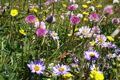
Portion de prairie fleurie - Marc EVENOT  Pastoralism
Estenc plateau hay meadows
The term “hay meadows” means areas of production of fodder which was not deliberately planted and which are rich in variety of species. The hay is harvested to feed animals. These meadows are part of the non-intensive and environmentally friendly practices and they encourage a wide variety of plants to grow.
Mercantour National Park has 1000ha of hay meadows, included in a pastoral and grassland domain covering around 120000ha. Within this, 90 professional farms are based in the Park’s communes and 268 transhumant farmers are present in summer.
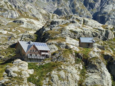
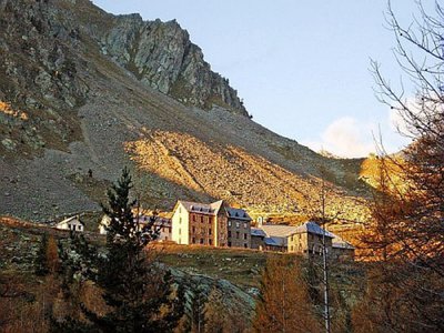
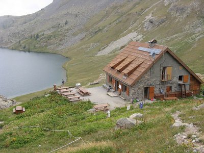
Refuge de la Cantonnière - Refuge de la Cantonnière  Refuge
La Cantonnière refuge
The history of the refuge is closely linked with the Route des Grandes Alpes connecting Lac Léman with the Mediterranean. It was built in the early 20th century by the French Touring Club with the very rudimentary means of the period by Italian workers, for whom the imposing Cantionnière house was built.
Accessible in summer 1913 to the few automobiles which were around at the time, the road was to be inaugurated by President Poincaré in August 1914. But the declaration of war deprived the people of Entraunes of this visit.
The building today serves as a refuge and has been fully renovated by Mercantour National Park.
Capacity: 36 in dormitories of 2, 4, 5 and 18.
Prices and opening periods: http://lacantonniere.wixsite.com/refugelacantonniere
Tel: 04.93.05.51.36
E-Mail: lacantonniere@gmail.com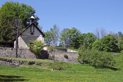
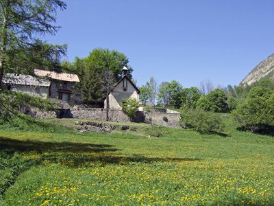
Chapelle Notre-Dame des Grâces à Estenc. - Marion BENSA  Small heritage
Estenc
In the 1930s, 15 families lived in Estenc, mainly as sheep and arable farmers (barley, rye). Life, virtually cut off from the rest of the world, was marked by poverty and rough. All the resources nature provided were made use of, but balance was maintained and a certain harmony existed between the people and the natural world. Currently, with rural desertification, the forest and fallow land are taking over; just a single farming family today remains in Estenc.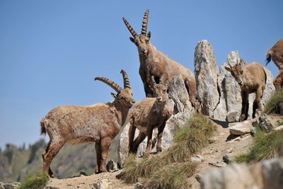
Bouquetin des Alpes, (Capra Ibex). Groupe de bouquetins. - Philippe PIERINI  Fauna
FaunaAlpine ibex (Capra ibex)
A symbol of the high mountains and their giddying peaks, this ungulate disappeared from this region more than 150 years ago.
Since 1987, reintroduction operations have been jointly undertaken by the Mercantour National Park and the Parco naturale Alpi Marittime.
A group of fifty or so have settled at Roche Grande.
To allow them to be identified, the animals are given coloured ear tags. The park staff regularly monitor the development of the species.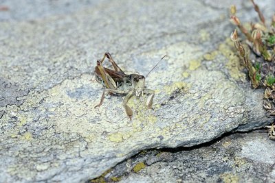
Gomphocère des alpages ou criquet de Sibérie, sur un rocher, (Gomphocerus sibiricus). - MALAFOSSE Jean-Pierre FaunaSiberian cricket (Aeropus sibericus)
During the great glacial periods, this orthoptera lived on the plains. As the climate has warmed back up, it has moved to the high mountains, above 2000m. The male can be recognised thanks to the its bulging back legs, hence its surname of “Popeye”. This herbivore, whose predators include birds, marmots and foxes, is part of the food chain in high-altitude pastures.
Zone humide dans le vallon de l'Estrop. - COSSA Jean-Louis PastoralismPastoralism
This grassy valley called Estrop (stropia: flock) a been used for pastoral purposes for many a long year: 1500 sheep graze it from August to September. The hut serves as a shelter for the shepherd. The flock rests on the knoll as the abundance of nettles and wild spinach attest. The Alpine grass is a fragile environment where the National Park helps ensure that a biological balance is maintained, while trying to improve the working conditions of shepherds.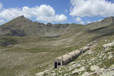
Blockhaus sous le col de Gialorgues dans le vallon de l'Estrop à Entraunes. - Marion BENSA  History and historical trail
Military remains
Just before the Second World War, the French army decided to build fortifications (bunkers) on Col de Gialorgues with a few to stopping a possible Italian invasion. Military authorities aimed to open a sufficiently wide track to allow all-terrain vehicles to reach Col de Gialorgues. Materials were transported by mules from the camp which was set up at the foot of the Estenc woods, but the soldiers had to rapidly give up due to the stony nature of the ground.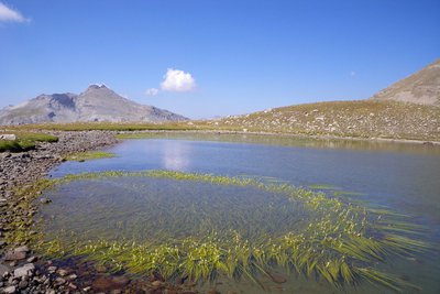
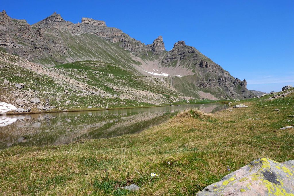
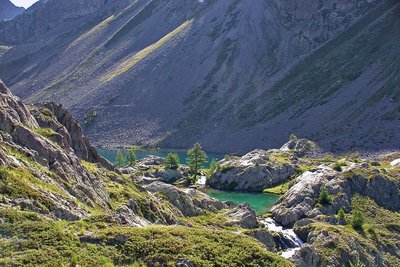
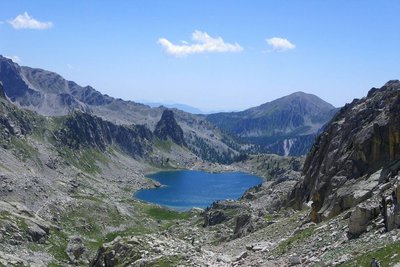
Le lac de l'Estrop un jour d'été, commune d'Entraunes. - Marion BENSA  Lake
LakeThe Estrop lakes
Around 10000 years ago, the glacier occupied the whole valley before it gradually shrank as the climate warmed up, leaving a body of water behind each glacial rock bar. Slowly, erosion overcame this stock of water. Ad you head up the valley, you are also heading back in time: grasses towards the bottom, peat bogs in the middle, lakes towards the top. Around the wetland areas, Arcto-Alpine species flourish such as the cane and Zweifarbige Seggen which are protected at both a national and a European level.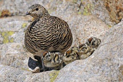
Lagopède alpin, (Lagopus mutus). En été, une femelle lagopède dans les rochers avec ses quatre poussins. - Jacques BLANC FaunaWhite-tailed ptarmigan (Lagopus mutus)
Also known as the snow quail (or “jalabre” in the local dialect), this bird of the Tetraoninae family is a familiar sight in the high mountains. It is perfectly adapted to the cold and lives all year round at 2500 - 3000m. Three to four times per year, it changes its feathers according to its surrounding environment. In the autumn, the ptarmigans can join together in groups of 20 to 25 individuals. Their main predators are stoats and golden eagles.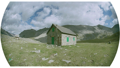
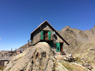
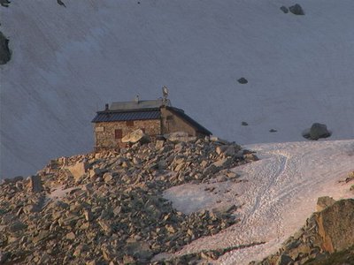
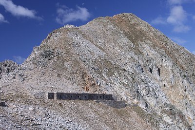
Le refuge de Gialorgues - PNM/DR RefugeGialorgues refuge
Capacity: 12 in refuge
Warden: No
Opening period: All year
Obligatory reservation
Pick up and drop off point for keys:
Hôtel Regalivou
04.93.02.49.00
St Etienne de Tinée
M. FERRAN 04.93.05.54.22
Estenc
In case of problems:
contact Nice CAF
michelle@cafnice.org
04 93 62 59 99
Useful numbers:
Park House: 04 93 02 42 27
St-Etienne de Tinée Tourism Office: 04 93 02 41 96
St-Dalmas Lodge: 04 93 02 44 61
Le fort du Camp des Fourches avec sa tourelle métallique dite « Séré de Rivière ». - Anthony TURPAUD History and historical trailRemoval zones
The depression on your right was one of the zones from where material was removed from to build Camp des Fourches at the start of the last century. The former military dry-stone track allows you to reach Cime de Pelousette.
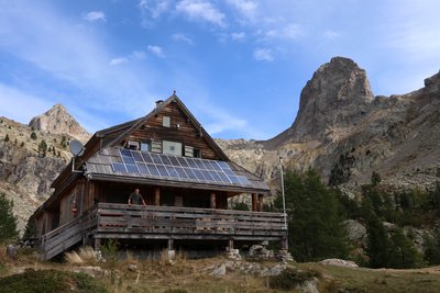
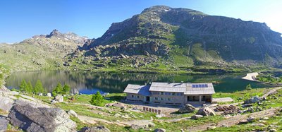
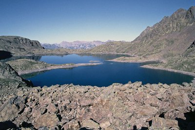
Refuge de Vens - CAF / DR RefugeLac de Vens and refuge
The Vens refuge only has a warden during the summer months. In winter, only one room is open to allow hikers to shelter. The Vens refuge overlooks a series of lakes of the same name. These lakes are of glacial origin, they are the result of a long erosion process by glaciers. The lake below the refuge (the biggest) is 31 metres deep. Ibex, chamois, mouflons and golden eagles can often be seen at the site. Very close to the refuge, you can see the endemic plant which was for a long time the symbol of the Mercantour National Park: Saxifraga florulenta.
Club Alpin Français: Capacity: 45 in summer and 30 in winter (no warden)
Reservations only be e-mail in summer: http://refugedevens.ffcam.fr/reservation.html
No shower, meal included
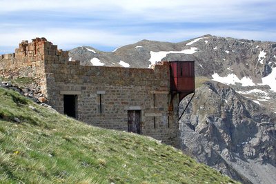
La visuale da una delle gallerie che ospitavano la Batteria del Druos - Roberto Pockaj History and historical trailThe Druos Artillery Battery
Near the Bassa del Druos there are the ruins of a shelter and the Druos Battery, a defensive military gun emplacement in a cave of the Vallo Alpino. The artillery battery, realized with minimum investment in the mid-thirties, consisted of 4 100/17 howitzers captured from the Austrians in WWI. The guns were positioned in the cave without any shielding whatsoever: there wasn't even a command room inside. Two of the 4 galleries where the cannons were placed can still be seen clearly, but the entrances to the other two have been obstructed by landslides.
La caserma del Druos ai Laghi superiori di Valscura - Roberto Pockaj History and historical trailThe Massimo Longà Barracks
The barracks are named for Massimo Longà, Captain of the Alpine Corps, who died on Monte Ortigara on 10 June 1917 (to be precise, on an Army Corps of Engineers map, the Rifugio's name is indicated as Massimo Mongà, differently from the inscription on the plaque over the main entrance). The barracks building is an imposing structure, built, according to documents of the Engineering Corps, in 1903. Other sources give the date of its construction as between 1916 and 1917, thanks to the forced labor of Austrian prisoners captured on the Eastern front, but if the Engineering Corps documents can be believed, it is more probable that the barracks were only restructured during the WWI years.
Il tratto lastricato della strada di arroccamento che collega Valscura a Fremamorta - Roberto Pockaj History and historical trailThe former military mule track "Valscura Barracks - Fremamorta Shelters"
The portion of the route that runs from Lower Lake Valscura to Lake Claus follows the former military mule track that linked Valscura and Fremamorta. The mule track is one of the best-preserved examples of the old military roads that ran through the Valle Gesso, as well as a true masterpiece of engineering. Realized sometime around the very first years of the nineteen hundreds, a decade prior to the start of the second world war, in 1929, it was preventively upgraded by the Dronero Battalion and maintained in perfect condition.
Over 10 km long, it never dips below an altitude of 2,000 meters and has a maximum incline of 18%. Portions of the road were skillfully paved with flagstones, still in place today.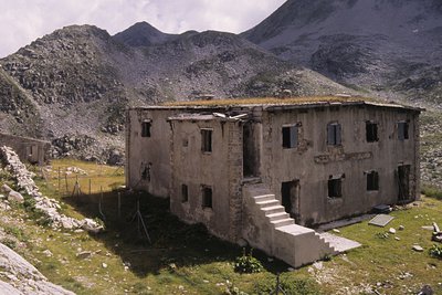
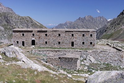
Il ricovero Umberto I - Roberto Pockaj History and historical trailThe Umberto I shelter
This is in fact a large barracks, designed to house 130 soldiers and 4 officers. Built in 1894, it was readapted on three separate occasions, the last of which in 1934, when another section was added on one side of the main building to house the kitchen, and a freestanding structure was also erected. The ruins of an old storage barn and stables can be seen just above the barracks.
La Casermetta difensiva Colle Fremamorta e la Cima di Fremamorta - Roberto Pockaj History and historical trailThe Cima di Fremamorta barracks
The barracks building is an imposing structure and is still in relatively good condition: The camouflage paint on the doors is still visible, and there are a good number of windows and doors left, outside and inside. Outside, there are traces of the open-air kitchen, used by the troops during the warm months. The barracks could house a garrison of 60.
Along the last stretch of uphill trail, as well as in the nearby Val Morta, there remain a few telephone poles in larch, on which were strung the wires for communications between defensive outposts.
Panorama sur la chaine transfrontalière Argentera-Mercantour depuis les barres du Mont Mounier, (sommet à 2817 mètres). - PIERINI Philippe  Geology
Argentera granite
If you look closely at this grey rock, you will see that it is made of different minerals. Quartz (grey) and feldspar (white) sometimes big with a few sparkling areas here and there on the rock. This is black mica and more specifically biotite.
You have discovered blocks of granite. All the minerals it is made up of are contiguous and visible with the naked eye. The texture is igneous, characteristic of plutonic rocks which crystallised deep in the earth.
La cime de l'Agnellière, (2699 m) et la cime de Juisses, (2580 m), depuis le haut Boréon, zone humide. - GUIGO Franck History and historical trailVillage of Boréon
In the past, Boréon was part of Italy and only became French in 1947; its access road dates from the 1950s. This domain of more than 4000 hectares, a former reserve of the kings of Italy, essentially consists of pasture and forests. It was formerly a haunt of salt smugglers.
Today, all of this natural valley is a classified site. Its development is based on tourism which respects natural environments.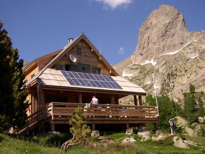
Refuge de la Cougourde - CAF / DR RefugeLa Cougourde refuge
Club Alpin Français
Warden: June – September: Manuel Putelat
September – June: Charly Barcelo: 06 18 54 02 43
Reservations by telephone or e-mail: refugelacougourde@ffcam.fr
Refuge landline: 09 78 23 31 59
Website: http://refugelacougourde.ffcam.fr/
Useful numbers:
St-Martin-Vésubie Tourism Office: 04 93 03 21 28
Park House: 04 93 03 23 15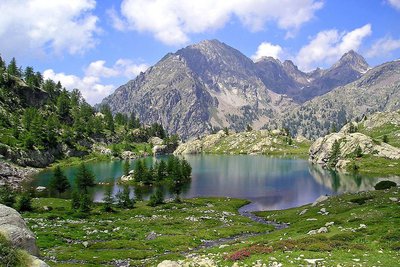
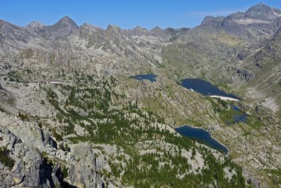
Le lac de Trécolpas en été, (2150 m) - GUIGO Franck  Know-how
Mountain climbing in the Mercantour
At the start of the 20th century, for the first mountain climbers, the Mercantour was a taste of adventure. Little by little, the summits of the chain were conquered, initially via the normal routes and then, with the arrival of modern mountain climbing, along the most difficult routes. From Victor de Cessole to Patrick Bérhault, the greatest names have been involved in climbing in the Mercantour. Today, whether they are snowy, icy or rocky, the reputation of certain routes is well established.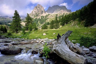
Vieille souche et portion de tronc de mélèze dans le torrent de la Madone de Fenestre face au Cayre de la Madone. - RICHAUD Philippe History and historical trailTerre de cour
The black rock marks one of the borders of the Terre de Cour, formerly a domain of the Count of Provence, before it was returned to the House of Savoy in the 14th century. Two inscriptions on the black rock provide a reminder of the past: “B” for Belvédère, “SM” for Saint-Martin-Vésubie. Terre de Cour was located exclusively in these two communes but they have to share the ancient rights to pasture and wood with Lantosque and Roquebillière.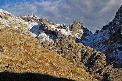
Dans l'ombre à droite le pas du mont Colomb, (2548 m). - GUIGO Franck GeologyThe scars of erosion
When they converge, runoff streams of water leave the ground bare, breaking a fragile equilibrium. In addition, footfall due to tourism damages the ground and raises the question of preservation of natural environments. Plant cover has to be maintained as it protects the ground from erosion and guarantees its stability. Restoration work has been carried out to guide and direct the hundreds of hikers who love these wild areas.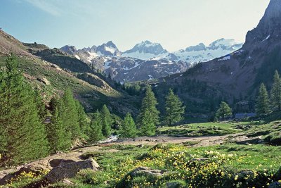
Le Gélas encore bien enneigé en fin de printemps, depuis le vallon de la Madone de Fenestre - LOMBART Guy History and historical trailCol de Fenestre mule track
This track has been used for a thousand years and was regularly maintained to allow mules transporting salt to pass with ease. The technique used to make and maintain these tracks involved self-locking stones. Identically sized slabs were arranged vertically in close lines. Fine materials were then used to hold it all in place. Gutters provided a run-off area for rainwater.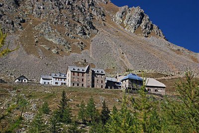
Depuis le vallon, le sanctuaire de la Madone de Fenestre en début d'automne - LEBOUTEILLER Eric History and historical trailLa Madone de Fenestre sanctuary
In the 8th century, a modest refuge already, providing accommodation for travellers. This sanctuary with its imposing forms was built by the Benedictines of Borgo San Dalmasso and destroyed by the Saracens in the 10th century. The Templars restored it in the 13th century shortly after the Virgin Mary appeared at the Grand Caire window. Subsequently, the sanctuary was devastated by fire several times and then rebuilt. Today it belongs to the diocese of Nice.
Refuge de la Madone de Fenestre - CAF / DR RefugeLa Madone de Fenestre refuge
Club Alpin Français
Capacity: 62 Possibility of eating and having a shower
Warden: Mid-June to late-September + school holidays and weekends in winter
Tel. 04 93 02 83 19
Out of season upon reservation: Patrick Miraillet: 04 93 03 91 02
Online reservations: http://chaletmadonedefenestre.ffcam.fr/
Useful numbers:
St-Martin-Vésubie Tourism Office: 04 93 03 21 28
Park House: 04 93 03 23 15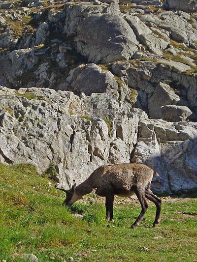
Chamois (Rupicapra rupicapra) près du refuge de Nice en Gordolasque à la fin de l'été - MALTHIEUX Laurent FaunaChamois (Rupicapra rupicapra)
A mammal of the Bovidae family and the subfamily of the Caprinae, the chamois (Rupicapra rupicapra) is a mountain dweller par excellence. It can climb 1000m upwards in 15 minutes (a hiker would take 3 hours). It can be recognised thanks to its horns, which are straight and then curved backwards, and quite small compared to those of the ibex.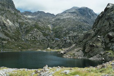
En Gordolasque, le lac de la Fous et le refuge de Nice - LE BOUTEILLER Eric History and historical trailThe Salt Road
The track which leads to the Nice refuge is one of the secondary passages of the Salt Road via the “Pas de Pagari”. Frequented since ancient time, this Pas gets its name from Paganino dal Pozzo,an Italian entrepreneur who, in 1453, was appointed as salt tax adjudicator by the Duke of Savoie.
Paganino was responsible for the construction of a new route via the “Pas de Pagari” to transport salt from Provence to Cuneo in Piedmont.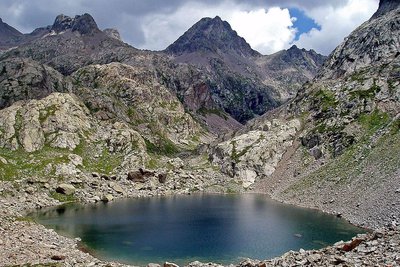
Le lac Niré, (2353 m), et la cime de Chamineye, (2921 m), le 29 septembre 2006, - GUIGO Franck GeologyThe eclogite of Lac Niré
Just above Lac Niré, on the right bank of the mountain stream, among the migmatite, can be found very dark rocks which take the shape of huge lentils (geologists call them “black puddings”).
When you look closely at these one of these lentil, you can see very different minerals to the ones you find in migmatite. The rusty red coloured ones are garnet and the darker ones are amphibole.
This very distinctive rock with characteristic fine and very dense crystals is eclogite; it is quite rare and a remainder from oceans which have disappeared. It is a metamorphic rock which springs from the transformation of basalts, ancient lava from the oceanic crust.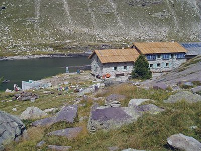
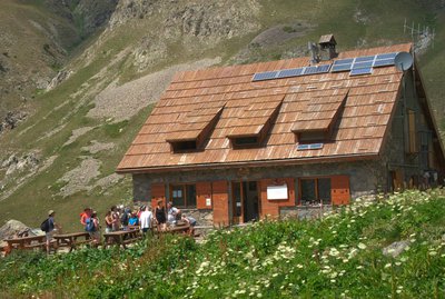
Le refuge des Merveilles - MALTHIEUX L. RefugeLes Merveilles refuge
Club Alpin Français
Capacity: 75 in refuge – Possibility of eating and having a shower
Warden: 15th June to 15th September: Hugo PUTELAT
(Refuge telephone): 04.93.04.64.64
Winter: October to June (upon reservation): Mouloud CADDUR refugedesmerveilles@ffcam.fr
The refuge is therefore OPEN for self-catering and with a warden when a reservation is made for 8 people or more, 19 places available for hikers who have covers (2 per person) and pillow.
If you wish to have a warden at the refuge, contact: refugedesmerveilles@ffcam.fr
Useful numbers:
Tende Tourism Office/Park House: 04 93 04 73 71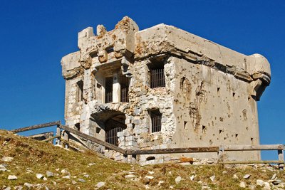
Le fort de la Redoute à l'Authion, (2080 m), à la Pointe des Trois Communes. - Franck GUIGO History and historical trailRedoute des Trois Communes
La Redoute des Trois Communes is a French fort which was built in 1898, in the Authion mountain chain under the command of Général Séré de Rivières.
In the 1870s, relations between France and Italy were conflictual. When the Comté de Nice became part of France (24th March 1860), it made Authion even more important as it had become a border chain, the keystone of defending the Maritime Alps. Huge fortification works began to make any possibility of the Italians breaking through impossible. Access to the chain was facilitated by several strategic roads being opened, leading to La Redoute des Trois Communes (1898) and to the forts of La Forca (1883-1890) and Mille Fourches (1883-1890).
A l'Authion, la piste de la Dea - CEVASCO Jean-Marie History and historical trailL'Authion
Glory and exaltation, but also suffering and death. L'Authion has seen the tragic end of many a life.
In April 1794, the Italian army, commanded by Generals Bonaparte and Masséna, fought against Austro-Sardinian troops: after extremely violent battles, L’Authion was taken. The Piedmont road was open to the French!
Then spring 1945 also saw L'Authion’s destiny being determined by more modern weapons. Despite the Operation Dragoon Provence landings in August 1944, the Alpine front, including the advanced post of L'Authion, was solidly held by the German army.On 1st March, General de Gaulle created the Alps Army detachment, which was responsible for defending communication lines.
L'Authion - GOURON Claude History and historical trailA natural fortress
Authion is a natural fortress which is virtually unconquerable, protected by its immense and steep slopes which "tower 1500m above the valleys of Caïros, Roya and Bévéra".
The relief provides no refuge, no hiding place for attackers who are extremely vulnerable. “You only need a very few men in a dominant position to completely close off access”. (Général Y. Gras).
At the very top, the summits which tower over the 2000m mark are equipped with fortifications which the “the gigantic field work and network of mines” make impregnable.
Just one weak spot: the south!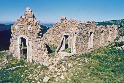
Les ruines de casernement de Cabanes vieilles à l'Authion, (2080 m). - pnm History and historical trail22nd March 1945
The order is received “to look into the possibilities of attacking the fortified mountain of L’Authion”. It would be “a powerful frontal attack on L'Authion that two columns, approaching from either side, would take it from behind, one via Col de Raus and the other via Ortighea Giagiabella ".
On 9th April, a general offensive by the Allies was launched on the Italian front. The enemy was to be pinned onto L'Authion.
The weather played its part: snow and mist enveloped L’Authion, forcing everyone to go through the anxiety caused by silence and expectation.
On 10th April, the bombing of the forts by military aircraft formed a brutal wakeup call, France launched an offensive and too the Forca ridge.
Altimetric profile
Recommandations
Access and parking
PUBLIC TRANSPORT
For those who choose to opt for public transport, here are the main connections from Nice, and links to the relevant web-sites to access information online:
- Estenc: line 790 Nice - Entraunes (terminates at Entraunes village).
All information on www.lignesdazur.fr or www.ceparou06
TRANSPORT ON DEMAND
In order to facilitate the access to Estenc village, the Département set up with the Region transport on demand service, connecting with the regional line Nice / guillaumes / Entraunes. This service (booking requested) operates only on July, august and September. For more informations about schedules and use please connect to the website www.randoxygene.org
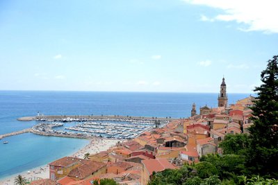
To travel back from Menton to Nice,
Transport possibilities:
- by bus: line 100 Menton - Nice : all information on www.departement06.fr or www.ceparou06.fr
- by train: line SNCF Menton - Nice : all information on www.ter.sncf.com/paca or www.ceparou06.fr
Report a problem or an error
If you have found an error on this page or if you have noticed any problems during your hike, please report them to us here:
Close by15
- Mountain Hut
- Mountain Hut
- Mountain Hut
- Mountain Hut
Mountain Hut
Rifugio Questa 2388 m
The Emilio Questa mountain hut stands on a rocky peak on the northern shore of Lake Portette, in the heart of a vast valley surrounded by the peaks of Portette, Claus, and Prefouns. It is an ideal spot for nature hikes: visitors can spot chamois, ibex, marmots, and the iconic bearded vulture.