Alta Via dei Re, stage 4: from Refuge Remondino to Refuge Genova Figari
Valdieri
4. Alta Via dei Re, stage 4: from Refuge Remondino to Refuge Genova Figari
Hard
3h30
5,1km
+466m
-922m
Walking breaks
Embed this item to access it offline
A few lines are sufficient to describe the environment that hosts this stage: high mountain, with steep rocky walls, immense slopes covered with scree, basins often invaded by snow even in the heart of summer. Two lakes, one of which is artificial, await us on arrival at Refuge Genova Figari.
1 point of interest
Saxifraga in fiore - Cati Caballo  Flora
FloraThe saxifrage of Argentera
The Argentera saxifrage (Saxifraga florulenta) is a herbaceous species already present on the mountains of the Argentera-Mercantour group before the ice ages. It lives in the fissures of siliceous rocks above 1600 meters of altitude. One of its most interesting characteristics is its very slow development: every year it produces very few leaves, it blooms after an interminable vegetative phase producing a panicle full of a hundred pinkish-white flowers and then dies, not before having dispersed thousands of tiny seeds.
Description
Behind the Refuge Remondino (2464 m) we follow the red-white marks facing east. One immediately rises up steep slopes, going up canals and stones. Turning to the southeast, we leave on the left the trace for Lake Nasta, then we cross large almost flat slabs and we arrive at a second fork: we ignore in front of us the trace for the East Mercantour Pass and we turn left.
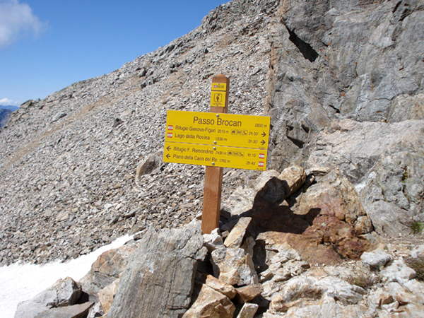
Not too steep and fairly stable rocky outcrops precede the short steep ramp leading to the Col de Brocan (2892 m, 1h40 from Refuge Remondino).
The descent into the Vallon de la Rovina is immediately abrupt: one crosses the detritic basin below, almost always covered with snow, staying on the left (when it is not better to pass directly the névé), then one crosses at the foot of rocky walls and one descends into the next valley, often also covered with snow. We stay on the left one more time, to go to find a trace of discreet path. The trace (round yellow marks and rare white and red marks) descends along a difficult, steep rocky outcrop to an altitude of about 2700 m.
One continues towards the east, along the line of maximum slope: around the altitude 2400 the marks lead first to the left (north), then again to the east to go down in a steep canal. A part on a wide ridge goes down finally on the pleasant path for the Col de la Rovina.
We follow it to the left, we go down a rocky ledge and we arrive at Brocan Lake (2004 m).
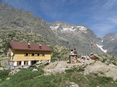
You will come to the Genova-Figari Refuge (2009 m, 1h55 from Brocan Pass).
Translated with www.DeepL.com/Translator
Not too steep and fairly stable rocky outcrops precede the short steep ramp leading to the Col de Brocan (2892 m, 1h40 from Refuge Remondino).
The descent into the Vallon de la Rovina is immediately abrupt: one crosses the detritic basin below, almost always covered with snow, staying on the left (when it is not better to pass directly the névé), then one crosses at the foot of rocky walls and one descends into the next valley, often also covered with snow. We stay on the left one more time, to go to find a trace of discreet path. The trace (round yellow marks and rare white and red marks) descends along a difficult, steep rocky outcrop to an altitude of about 2700 m.
One continues towards the east, along the line of maximum slope: around the altitude 2400 the marks lead first to the left (north), then again to the east to go down in a steep canal. A part on a wide ridge goes down finally on the pleasant path for the Col de la Rovina.
We follow it to the left, we go down a rocky ledge and we arrive at Brocan Lake (2004 m).
You will come to the Genova-Figari Refuge (2009 m, 1h55 from Brocan Pass).
Translated with www.DeepL.com/Translator
- Departure : Remondino refuge (2464 m)
- Arrival : Genova Figari Refuge (2009 m)
- Towns crossed : Valdieri and Entracque
Altimetric profile
Recommandations
At Passo del Brocan it is possible to find snow all year round so it may be essential to have an ice ax and crampons for a safe crossing
Is in the midst of the park
The national park is an unrestricted natural area but subjected to regulations which must be known by all visitors.
Report a problem or an error
If you have found an error on this page or if you have noticed any problems during your hike, please report them to us here:
Close by2
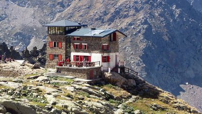
- Mountain Hut
Mountain Hut
Rifugio Franco Remondino 2464 m
The mountain hut, owned by the CAI of Cuneo, is named after Franco Remondino, a second lieutenant in the Alpini and a rising star of mountaineering in the Cuneo area who lost his life in 1931, at the age of twenty-one, while climbing the southeast face of Rocca Gialeo with his companion, Lieutenant Erasmo Vivarelli.