3. Alta Via dei Re, stage 3: from the Valasco Refuge to the Remondino Refuge
3 points of interest
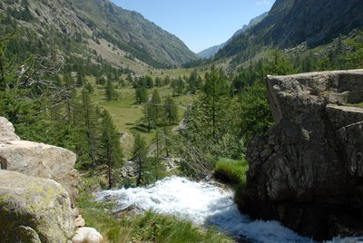
Il Lariceto - Cati Caballo  Flora
FloraThe larch
This type of forest is rather localized in the Maritime Alps, which notoriously represent the realm of the beech forest. It covers the slopes at the heads of the valleys with sparse and luminous populations, sometimes grazed by the herds that have climbed the mountain pastures. Most of the time their purity is not natural, but induced by man: in fact, over the centuries, man has favored this tree species to the detriment of others, such as the stone pine, for example, because they are less favorable for exercising the grazing due to the increased shading of the soil.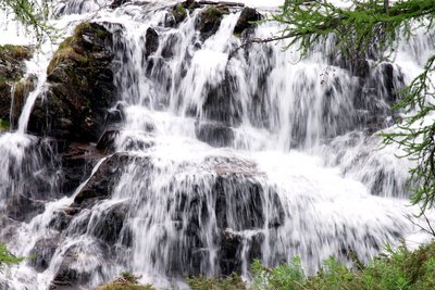
La cascata all'imbocco del Pian del Valasco - Roberto Pockaj  Geology
The Pian del Valasco waterfall
The mass of rocks over which the water falls is a typical example of a glacial rock step. During the glaciations it formed the lower limit of the lake at the foot of the glacier. A tongue of the glacier extended beyond the step.
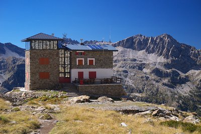
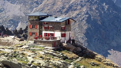
Il Rifugio Remondino - Roberto Pockaj  History and historical trail
The Remondino Refuge
The Refuge is named for Franco Remondino, Jr. Lieutenant of the Alpine Corps and budding local climber, who died during an ascent on the Rocca Gialeo. A half-barrel bivuoac shelter that sleeps 12 was erected in his memory and inaugurated in 1934. It was later decided to build a real refuge on the spot, in masonry, erected thanks mostly to the financial sponsorship of the Saluzzo Battalion of the Alpine Corps, the Taurinense Division of the Army Corps of Engineers and the 1st Airborne Brigade and inaugurated in 1965. Additional restructuring and extensions were completed in the year 2000.
Description
From the Valasco Refuge (1763 m), the trail leads towards Terme di Valdieri until it reaches the former military road for the Valscura lakes. The route turns left onto the road and follows it up to the upper Piano del Valasco. At the fork on the other side of the wooden bridge, the route takes the mule track on the left.
The mule track climbs up through the larches with long switchbacks and then, reduced to a trail, climbs in tight turns to the foot of the sheepbacked rock face. The trail skirts the edge of a deep ravine, then proceeds up the Val Morta with a long traverse on the orogaphic right, joining up with the former military mule track coming from Valscura.
The route follows this broad road to the left, climbing in switchbacks and long traverses up to the Colletto del Valasco pass(2423 m, 2 hours and 20 minutes from the lower Piano del Valasco).
On the other side of the pass, the mule track descends to the nearby lower Lake Fremamorta (2354 m), where it passes by a turnoff on the left for the Gias delle Mosche. The track continues on to the intermediate Lake Fremamorta (2375 m, 20 minutes from the Colletto del Valasco), where it turns to the left onto the trail leading to Pian della Casa.
After a few turns, the trail passes by the turnoff on the right for the upper Freemamorta lakes and descends, in a series of traverses and switchbacks, to the edge of the hollow where the lower Gias della Losa stands: here the route passes by a trail on the left for Pian della Casa (shorter, but recommended for expert hikers only), and climbs uphill over a ridge.
The shortcut for expert hikers down to the Pian della Casa del Re joins up with the main trail again at the turnoff for the Regina Elena Refuge.
On the crest, the route passes by a turnoff on the right for the Colle di Fremamorta pass and begins another long descent, to the northeast, with steep, tight switchbacks, then joins up with the more comfortable trail heading for the Colle di Ciriegia.
The route follows this trail to the left for about fifty meters, where there is a poorly marked triple fork: from the left the shortcut rejoins the main trail, while the trail on the right leads to the Regina Elena Refuge. The route leaves the trail it is on and turns right, indicated by occasional white trail markers leading through the field of rubble and shrubs.
Shortly before coming to the Regina Elena Refuge (1833 m, 1 hour and 30 minutes from the intermediate Lake Fremamorta), the route stays on the left, on the main access path to the Refuge. The trail descends along a small ridge among detritus and the occasional larch and, now at the bottom of the valley, winds along the various tributaries of the Gesso della Valletta torrent, crossing over two of them on wooden footbridges.
The abovementioned trail to the right leads to a ford and a brief climb up to the trail for the Remondino Refuge, following a shorter route.
The tortuous trail leads to a poorly maintained dirt road, which the route follows to the left until joining up with the trail for the Remondino Refuge on the right. Inverting its direction, the trail at first remains parallel to the road, then turns eastward. Climbing with tight switchbacks along a rocky ridge, the trail comes to some arduous stepped tracts and a footbridge across the torrent coming from the Vallone dell'Assedras.
Passing by the turnoff on the right for the Colle del Mercantour pass, the route continues to climb for a long stretch, with many switchbacks through the rocks and sparse larches. The path climbs up a gully with steep switchbacks, through a detritic hollow and then, after a final vertical climb on large steps, arrives at the Remondino Refuge (2464 m, 2 hours and 25 minutes from the Regina Elena Refuge).
- Departure : Valasco Refuge (1763 m)
- Arrival : Remondino Refuge (2464 m)
- Towns crossed : Valdieri
Altimetric profile
Recommandations
Report a problem or an error
If you have found an error on this page or if you have noticed any problems during your hike, please report them to us here:
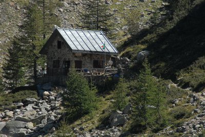
Close by3
- Mountain Hut
Mountain Hut
Rifugio Franco Remondino 2464 m
The mountain hut, owned by the CAI of Cuneo, is named after Franco Remondino, a second lieutenant in the Alpini and a rising star of mountaineering in the Cuneo area who lost his life in 1931, at the age of twenty-one, while climbing the southeast face of Rocca Gialeo with his companion, Lieutenant Erasmo Vivarelli.