Alta Via dei Re, stage 6: from Refuge Soria Ellena to Refuge Pagarì
Entracque
6. Alta Via dei Re, stage 6: from Refuge Soria Ellena to Refuge Pagarì
Hard
6h
9,6km
+1315m
-516m
Walking breaks
Embed this item to access it offline
Glacial lakes, glaciers, moraines and scree characterize a good part of this stage, where the probability of encountering closely groups of ibex is very high.
Description
From the refuge, we follow the road towards the valley until the start of the mule track which leads to the Col d'Fenestre. You walk towards the cross-border pass up to an altitude of 1910 m, where you follow the signs on the left for the Pera de Fener and the bivouac of Moncalieri. The path rises in hairpin bends through the rhododendrons and climbs the steep slopes of the Gorgia della Maura. The route then shifts towards the center of the Gorgia with short passages on scree, crosses the stream and continues to rise with other bends until the exit of loa Gorgia, at an altitude of 2200 m (source).
A valley now opens, less steep, towards the east, towards the summit of Gelàs, which stands out on the horizon. The mule track gains altitude by staying on the right bank (hydrographic) of the valley: at 2440 m you leave a trace on the right that leads to the Forcella Roccati (clearly visible at the top of the steep rocky canals), to go up with other hairpin bends, on a terrain of boulders, at the foot of the bastions of the top of Gelàs.
With a last series of bends, the path approaches the large rock called Pera de Fener (2698 m) ending at the old hunting hut (remains of shelters), at the foot of the North Glacier of Gelàs or Siula (3 hours from the refuge).
To the east, the view is limited by the proximity of the Cresta dei Ghiacciai where you can see the Passaggio dei Ghiacciai pass: upper (2950 m) and lower (2750 m). From this point you continue towards the lower Passaggio following the trace on the morainic ground to the left that reaches the edge of the glacier: the red traces help to find your way (if they are not covered by snow). Then we reach the Cresta dei Ghiacciai (crest of the glacier) and, along a ledge, we reach the lower pass of the Gelàs glacier. Follow the ridge towards the valley for a few metres then descend to the bivouac of Moncalieri (2710 m - about 4 hours). The path (red tracks) quickly reaches the white western lake of Gelàs (2550 m), on the northern bank of which the remains of the ancient Refuge Moncalieri are found.
Leaving on the left the track which, going along the lake, goes down to San Giacomo, turn right towards the east, towards the distant peaks of Lake Agnel (red marks, some kairns).
On an outcrop of boulders, we reach Lake Bianco Orientale del Gelàs, 2500 m (4.45 hours). Continue eastward along the left bank of the stream that flows into the lake, passing it on stones at 2485 m above sea level.
Continue east, along grassy terraces, to pass another stream further at 2425 m . On a grassy surface covered with rhododendrons, the red tracks leave the east direction for a moment and bend to the left towards the northwest, to resume immediately after the east direction.
A small grassy ledge dotted with rhododendrons leads to a steep landslide, which determines the minimum point of the stage at 2390 m altitude. Cut the valley at the foot of steep rocks, now proceeding by hairpin bends perfectly preserved, and with a little "serpentine" finally climb to Passo Soprano del Muraion (2485 m), whose passage is identified by the gendarme 20 meters high left of the path.
The route crosses a conch and goes up with some hairpin bends the Cresta is del Muraion, just above 2585 m, from where you can see the refuge.
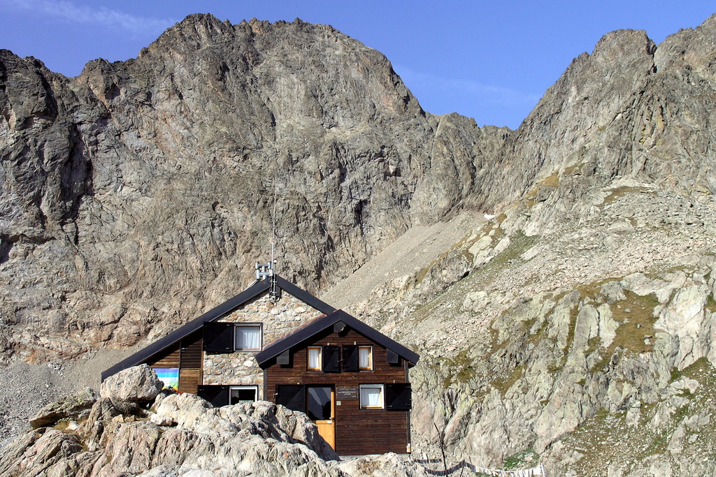
The trail crosses the stream of the Pagarì glacier and climbs through ancient military grounds carved into the rocky slope to the refuge.
A valley now opens, less steep, towards the east, towards the summit of Gelàs, which stands out on the horizon. The mule track gains altitude by staying on the right bank (hydrographic) of the valley: at 2440 m you leave a trace on the right that leads to the Forcella Roccati (clearly visible at the top of the steep rocky canals), to go up with other hairpin bends, on a terrain of boulders, at the foot of the bastions of the top of Gelàs.
With a last series of bends, the path approaches the large rock called Pera de Fener (2698 m) ending at the old hunting hut (remains of shelters), at the foot of the North Glacier of Gelàs or Siula (3 hours from the refuge).
To the east, the view is limited by the proximity of the Cresta dei Ghiacciai where you can see the Passaggio dei Ghiacciai pass: upper (2950 m) and lower (2750 m). From this point you continue towards the lower Passaggio following the trace on the morainic ground to the left that reaches the edge of the glacier: the red traces help to find your way (if they are not covered by snow). Then we reach the Cresta dei Ghiacciai (crest of the glacier) and, along a ledge, we reach the lower pass of the Gelàs glacier. Follow the ridge towards the valley for a few metres then descend to the bivouac of Moncalieri (2710 m - about 4 hours). The path (red tracks) quickly reaches the white western lake of Gelàs (2550 m), on the northern bank of which the remains of the ancient Refuge Moncalieri are found.
Leaving on the left the track which, going along the lake, goes down to San Giacomo, turn right towards the east, towards the distant peaks of Lake Agnel (red marks, some kairns).
On an outcrop of boulders, we reach Lake Bianco Orientale del Gelàs, 2500 m (4.45 hours). Continue eastward along the left bank of the stream that flows into the lake, passing it on stones at 2485 m above sea level.
Continue east, along grassy terraces, to pass another stream further at 2425 m . On a grassy surface covered with rhododendrons, the red tracks leave the east direction for a moment and bend to the left towards the northwest, to resume immediately after the east direction.
A small grassy ledge dotted with rhododendrons leads to a steep landslide, which determines the minimum point of the stage at 2390 m altitude. Cut the valley at the foot of steep rocks, now proceeding by hairpin bends perfectly preserved, and with a little "serpentine" finally climb to Passo Soprano del Muraion (2485 m), whose passage is identified by the gendarme 20 meters high left of the path.
The route crosses a conch and goes up with some hairpin bends the Cresta is del Muraion, just above 2585 m, from where you can see the refuge.
The trail crosses the stream of the Pagarì glacier and climbs through ancient military grounds carved into the rocky slope to the refuge.
- Departure : Refuge Soria Ellena (1840 m)
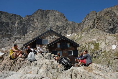
- Arrival : Refuge Federici Marchesini al Pagarì (2627 m)
- Towns crossed : Entracque
Altimetric profile
Recommandations
Is in the midst of the park
The national park is an unrestricted natural area but subjected to regulations which must be known by all visitors.
Report a problem or an error
If you have found an error on this page or if you have noticed any problems during your hike, please report them to us here:
Close by2
- Mountain Hut