2. Alta Via dei Re, stage 2 : from the D. Livio Bianco Refuge to the Valasco Refuge
2 points of interest
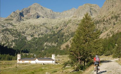
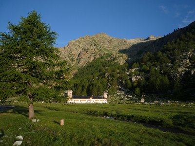
Tête du Claus (2897m), surplombant le refuge de Valasco en été - A. Rivelli / PNAM  History and historical trail
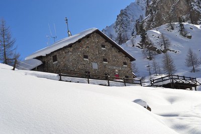
Refugio Valasco, former hunting lodge
This is where King Victor Emmanuel II of Italy had a hunting lodge built, a singular “castle”, square in shape and with a crenelated tower. It has since been transformed into a high-altitude refuge, much to the delight of hikers.
From the Valasco plateau where the refuge is located, you can easily reach the area of the Valascura lakes, heading along the magnificent road built by hunters in the early 20th century. Part of the road is paved, allowing you to go through an area which is littered with boulders and debris.
A mule track leads to the panoramic col of Valmiana.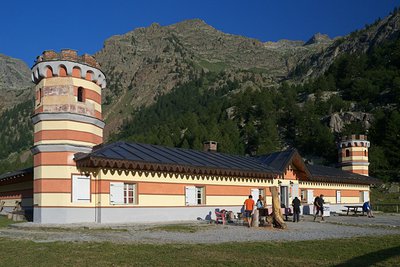
Il Rifugio Valasco - Roberto Pockaj History and historical trailThe Valasco Royal Hunting Lodge
The construction of a "Country House" in Vallasco, which Vittorio Emanuele II would later utilize for his hunting parties in the Royal Reserve, dates back to the years after 1868, when there were probably four buildings standing on the plateau. However, the Royal Hunting Lodge, at least the one we admire today, was probably built after 1873, although sources differ on this.
Its history has been turbulent, and marred by a series of fires until, following an important restructuring by its current owner, in 2008 it was transformed into an alpine refuge.
Description
From the Livio Bianco Refuge (1890 m), the route returns to the last fork before the Gias del Lago and turns left, cutting diagonally across a grass and rubble-filled slope. With a number of switchbacks, the trail surmounts a large bastion of sheepbacked rocks and comes to the flat area on which the Gias Gros sits.
After crossing the flat area, the old mule track starts climbing again in a series of switchbacks through detritus, surmounts another bastion and comes to a fork (at the feet of the little waterfall formed by the drainage stream spilling out of upper Lake Sella). The route continues to the left, passing over a bastion of sheepbacked rocks before decending into the detritus-filled hollow below it. Passing by the turnoff on the left for the usual route to Monte Matto, the path shifts over to the orographic left of the valley and climbs in a very long series of switchbacks through fields of rubble. The switchbacks gradually become tighter and steeper (the trail tends to disappear for brief tracts) as the view opens up; the last few broad switchbacks lead up to the Colle di Valmiana pass (2916 m, 3 hours and 35 inutes from the Livio Bianco Refuge).
During the climb, do not be misled by Passo Cabrera, in plain view: located a little to the east of the Colle di Valmiana, it is the lowest point between Monte Matto and the Rocca di Valmiana, but it is not the point crossed by the trails.
Beyond the pass, the trail descends, first in steep, tight switchbacks on a rocky base, then in wide switchbacks on scree, following the spectacular ridge that drops down towards Punta Graveiretta. Without reaching the top of the little elevation, the trail veers west for a brief tract, crosses a small hollow filled with detritus and, reaching the base of a rocky ridge, comes to a fork at an elevation of 2483 m.
The route ignores the turnoff to the right for the Costa Miana pass and continues to descend southward. With a series of tight switchbacks alternating with brief traverses, the trail shifts to the orographic left side of the Vallone di Valmiana. After a few wide turns, the tight switchbacks begin again: the trail approaches the stream that runs through the bottom of the valley, then veers left, cutting across a rocky outcropping where some attention is called for, due to some portions that have been obliterated by rockslides.
The route now turns to the right, in a zigzag descent, and at around 1870 m, crosses the abovementioned stream. Leaving the watershed, the last turns cross a slope devastated by a huge avalanche during the winter of 2008/9, between heaps of boulders and fallen larches, and come to the unpaved road leading up from Terme di Valdieri.
The route follows the road to the right, crossing the lower Piano del Valasco (1763 m), an ancient glacial lake now completely filled in. When the road forks, the route follows the left branch, which ends a bit further on in front of the Valasco Refuge (1763 m, 2 hours and 25 minutes from the Colle di Valmiana pass), the former Royal Hunting Lodge of the House of Savoy.
- Departure : Dante Livio Bianco Refuge (1890 m)
- Arrival : Valasco Refuge (1763 m)
- Towns crossed : Valdieri
Altimetric profile
Recommandations
Report a problem or an error
If you have found an error on this page or if you have noticed any problems during your hike, please report them to us here: