La Malune
5 points of interest
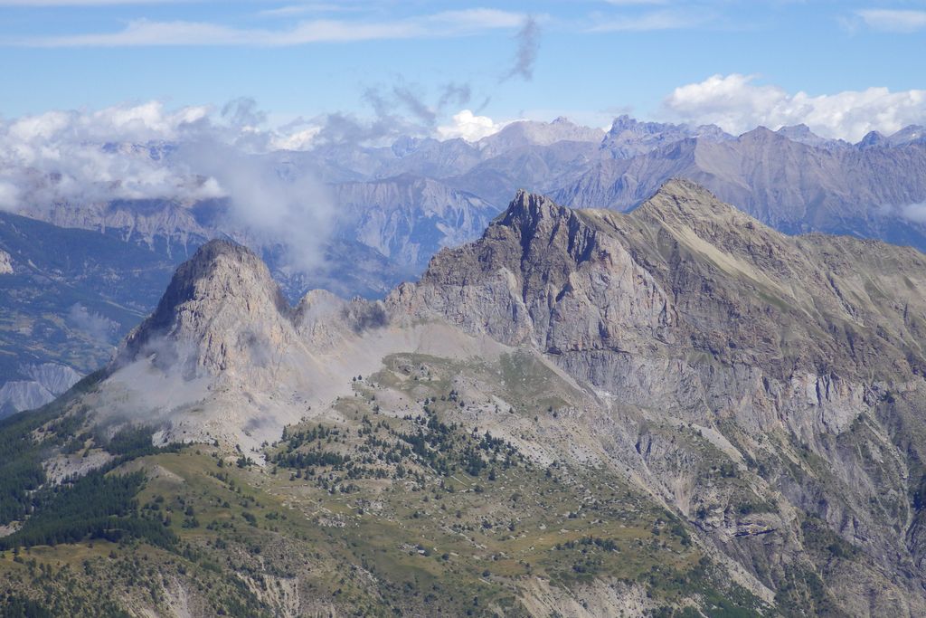
Molanès dans un paysage déjà hivernal en fin d'automne - GOURON Claude  History and historical trail
Hamlet of Les Blancs
Les Blancs now just consists of four or five farms scattered on the heights of Molanès. Pra-Loup, “the meadow of the wolf” is just an isolated farm.
Before humans arrived in this area, it was covered be a black forest of spruces and firs. The land was cleared by Benedictine monks, and these first inhabitants have left the memory of a priory and a convent. In place of the chalets and ski slopes, imagine a mosaic of fields and cultivated meadows. Barley, rye and lentils were successful crops and provoked some jealousy from the inhabitants of Uvernet, which was already the administrative capital of the area. History and historical trail
The Fau mountain stream
The mountain stream cut its way through a brittle black marl slope. It scoured and damaged this land which has been rendered fragile due to overuse by an excessively large population. At the start of this century, the Waters and Forests Service restored this entire zone and built several small dams to limit the amount of erosion at the bottom of the ravine.
The water from the mountain stream was used to water the meadows and for the animals; it was shared out in turn to each of the families in the hamlet.- History and historical trail
The Villaret farms
Less than a century ago, the Villaret hay meadows stood here, without a single tree. Before the Second World War, three families lived here.
Afterwards, the hamlet was abandoned and, all around, crops were replaced with hay meadows. Given that grazing was less intensive, the pastures quickly became fallow before the current larch forest moved in. 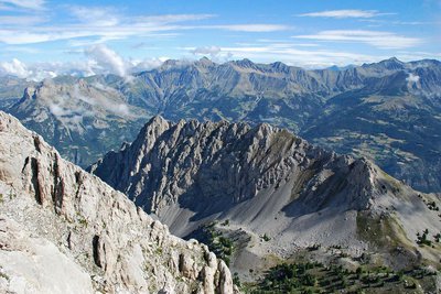
Vue plongeante sur la Séolane des Besses en été - BRETON François  Geology
The valley of Agneliers, the Pain du Sucre and the Séolane
The Pain de Sucre and the Séolane stand above the valleys of Fours and Agneliers. Could you imagine that one of those grey limestone mountains was dragged over 30km from the north-east?
A gigantic layer of soft rocks from the east (flysch) covered the rocks which were already there some 200 million years ago, ripping those huge masses which are the Pain de Sucre, the Chapeau de Gendarme and the Soléane from the Chambeyron mountains, dragging them and leaving them here. Millions of years of erosion have made them visible again, making them the elegant advanced guard of the Ubaye landscape.- History and historical trail
Malune farm
The Val d'Allos has, until very recently remained within Barcelonette’s sphere of influence and the exchanges between these valleys were plentiful. It was only in 1890 that a road replaced the poor mule track linking the two communities.
In 1903, Alpine coaches pulled by horses connected Barcelonnette to Allos over a 6-hour journey, with a 1-hour break at the refuge on the col to allow the horse to recover.
Finally, just before the war, in summer only, an Ubaye transport company provided travellers with a daily return service between Barcelonnette and Allos, along a road which was now tarmacked, at last using coaches which had tyres.
Description
The itinerary initially follows a comfortable track indicated by yellow markers. Go past the last chalets of the hamlet of Les Blancs.
First you will reach eroded areas dotted with pines before arriving at a forest hut and the Fau waterfall.
Continue south by taking the marked path towards "La Malune"; it continues almost flat around the edges of the ruined farms of Le Villaret.
Subsequently, the slope steepens in through a larch forest, crosses a partially reforested avalanche slope and climbs to 1730m, coming out at the untamed Agneliers valley.
The path then heads downwards, arriving at the meadows near Malune Farm and overlooking the road up the Col d'Allos.
Follow the same route on the return journey.
- Departure : Les Blancs
- Arrival : Les Blancs
- Towns crossed : Uvernet-Fours
Altimetric profile
Access and parking
Parking :
Report a problem or an error
If you have found an error on this page or if you have noticed any problems during your hike, please report them to us here: