Ring of the Bandito and the Butterflies

Valdieri
Ring of the Bandito and the Butterflies
Easy
3h
9,2km
+238m
-238m
Loop
Embed this item to access it offline
The butterfly trail itself takes about half an hour to visit: to make the excursion more interesting, proceed on the two banks of the Gesso stream, taking advantage of the beautiful cycle path. This brings you to the sunny hamlet of Andonno, the famous Grotte del Bandito, the ancient home of the cave bear and today a nature reserve, the capital Valdieri where a stop for refreshment is a must and, finally, the short but evocative circuit dedicated to lepidoptera. Easy and with a very modest difference in height, the naturalistic and cultural itinerary can be covered on foot or by mountain bike.
3 points of interest

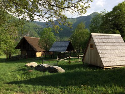
Ricostruzione di capanna e fornace dell’Età del Bronzo presso la necropoli di Valdieri - Irene Borgna  History and historical trail
The necropolis
The necropolis is located along the old road to Valdieri, inside a suggestive wide and well-exposed basin, on the slopes of Rocca San Giovanni and Punta Saben, which host the homonymous nature reserve. High rocky walls protect the plateau from the cold northern currents and favor a warm and dry climate, with little rainfall even in the winter months. It is probably for these reasons, as well as for the excellent position overlooking the confluence of the two branches of the Gesso stream, that - on several occasions from the Bronze Age to the Iron Age - the tombs of some characters were placed on this site important members of the community, perhaps leaders or priests. Eleven incineration burials, a cenotaph and some ritual pits were found: the many finds are kept in the nearby, small and interesting museum.
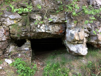
Esterno dell'ingresso - Irene Borgna  Geology
The Caves of the Bandito
When it's one of a kind, everything becomes precious. This is the case of the small Grotte del Bandito: important because they are the only karst system in the Gesso Valley. The remains of Ursus spelaeus, the ancient cave bear, were found here. Here the villagers have dug for a long time in search of gold flakes – and earning the sinister reputation of "bandits". Here, taking advantage of the stable climate of the caves, colonies of Bats winter, whose hibernation must not be disturbed at all, otherwise the bats will die. Species of invertebrates perfectly adapted to the underground environment live here. Due to their naturalistic and archaeological interest, the Grotte del Bandito are today a nature reserve included in the SCI IT1160056 "Marittime Alps": they are subject to protection and access to the cavities is limited.
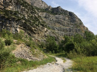
All’interno del sito della ex cava Cementir - Irene Borgna  Fauna
FaunaPapilio alexanor
Papilio alexanor is now found in a few places in Italy: sought after by collectors, the butterfly is in fact now at risk of extinction. One of the sites where he lives is the area of the former Cementir limestone quarry, others are located in Calabria and Sicily (not just around the corner). The area is particularly favorable to the reproduction of this species because it is warm, humid and rich in Ptychotis saxifraga, a small plant which grows on the rocks and which is the favorite of the Alexanor caterpillars. Precisely for this reason, during the area recovery works, the rock of the mountain was left as it was at the time of the quarry because the walls well warmed by the sun and rich in Ptychotis saxifraga are the ideal home for this species.
Description
From the bulletin board in front of the chapel, take the dirt road on the right in the quarry area towards Andonno (palina). At the first crossroads at the foot of the steps, turn right (boulder with notch): the path that comes from Valdieri will be the one used for the return. Proceed first uphill then descending again to road level to go up along a stream in the shade of shrubs and chestnut trees and then cross downhill on a dirt road as far as the first houses of Andonno, leaving the Chapel of the Madonna del Gerbetto on the left (point water). Arrived in the square of the hamlet of Andonno (fountain), go down to the provincial road, which you cross to reach and in turn cross the bridge over the Gesso stream. You will soon reach the shady village of Tetto Bandito (water point): here the cycle path begins and you take it to the right to quickly arrive in the shadow of the looming limestone wall that hides the Grotte del Bandito. In spring, it's better not to stay too long: in fact, unstable boulders have a tendency to choose the period of the thaw to decide to jump off. Walk along a sort of grassy beach along the Gesso stream and climb up and down towards the village of Cialombard. Proceed upstream among cultivated fields, pastures and rows of ash trees. At a trout farm (fountain), turn right onto the bridge to quickly reach Valdieri. You can take advantage of the fountain known as "della Bela Rosìn" to quench your thirst in front of the Art Nouveau villa, seat of the Protected Areas of the Maritime Alps, and then go back up in the direction of the town hall. Before the town hall, turn right onto Via Umberto I, a panoramic balcony facing south which you can walk up to the canopy that protects the site of the necropolis of Valdieri. Here you turn left and – browsing through the reconstructions of houses and furnaces from the Bronze Age – you take the real butterfly path, giving preference to the more interesting branch, the one that runs at the foot of the cliff. Following the white and red notches you reach the site of the former quarry, where in spring and summer you can observe the work of insects. Proceed east until you come back in sight of the chapel of San Giovanni and the starting point.
- Departure : Chiesa di San Giovanni (747 m)
- Arrival : Chiesa di San Giovanni (747 m)
- Towns crossed : Valdieri and Roaschia
Altimetric profile
Transport
Nuova Benese service company - Regular line Cuneo, Valdieri, Entracque - Telephone: 00 39 (0) 171 69 29 29 - www.benese.it
SNCF line TER Provence Alpes-Côte d'Azur For travel in the PACA region and towards Cuneo www.ter-sncf.com/pac
Trenitalia for travel in the Piedmont region https://www.trenitalia.com/it.html
SNCF line TER Provence Alpes-Côte d'Azur For travel in the PACA region and towards Cuneo www.ter-sncf.com/pac
Trenitalia for travel in the Piedmont region https://www.trenitalia.com/it.html
Access and parking
You park your car in the vast open space near the ruined Chapel of San Giovanni, just before the town of Valdieri. If you want to avoid crossing the provincial road, there are some parking spaces in front, right at the beginning of the path
Parking :
St. John's Church
Report a problem or an error
If you have found an error on this page or if you have noticed any problems during your hike, please report them to us here:
