1. On the mineral trail - Tour of the Marguareis Nature Park - Stage 1
3 points of interest
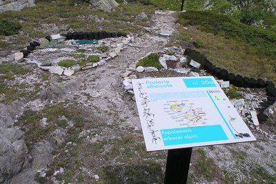
La stazione botanica Burnat Bicknell - Roberto Pockaj  Flora
FloraThe Burnat Bicknell Botanical Station
The site covers over 10,000 square meters, and is named after Emile Burnat and Clarence Bicknell. Burnat, a Swiss botanist, was the author of the important work 'Flores des Alpes Maritimes'; Bicknell, an English botanist active in Valle Pesio for about thirty years, he was also the first to catalogue the rock engravings of Monte Bego.
About 500 plant species typical of the Ligurian Alps are collected in the two botanical stations, offering a unique opportunity for both enthusiasts and casual visitors. Illustrative panels describe the various environments and the botanical species are easily recognizable thanks to the scientific name on the labels.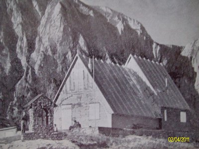
Il vecchio Rifugio Garelli - CAI Mondovì  History and historical trail
Pier Mario Garelli
The refuge was dedicated to Pier Mario Garelli when it was built. He was known to all as Piero, a lawyer and climbing partner of Sandro Comino. President of the CAI of Mondovì, immediately after the armistice he joined the Resistance, with the III Alpine Division operating in Val Casotto. He was arrested in Mondovì, and initially locked up in Turin. On May 25, 1944 he was transferred to the concentration camp at Fossoli, then to Bolzano and finally to the concentration camp at Mauthausen. He died in the subcamp of Gusen, just before the end of hostilities.
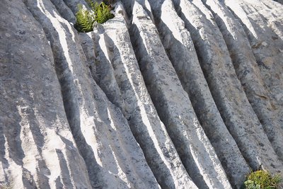
Fenomeni erosivi su rocce calcaree - Roberto Pockaj  Geology
The furrowed fields
The 'furrowed fields' (also called 'carried fields' due to the shapes that vaguely recall the furrows left by the wheels of carts in the mud) are erosion phenomena typical of limestone rocks, due to the runoff of rainwater.
Description
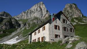
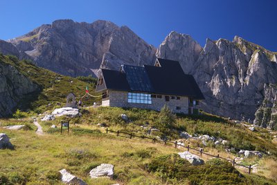
Head left along the road from the Pian delle Gorre refuge (1 032m) then turn left towards Pian del Creus. A steep hill through the silver fir forest of Buscaiè leads to the delightful Pian del Creus (1269m). After having gone past the cool Mantras spring, you will reach Gias Madonna (1653m). Here, turn right and, having gone along past Gias della Costa, you will reach Gias Soprano di Sestrera (1842m). From there, in just over half an hour, you will reach Pian del Lupo and subsequently the Garelli refuge (1970m), where you can visit the Alpine botanical station of Bicknell-Burnat, founded by the Park with the aim of saving the many endemisms of the Maritime and Ligurian Alps. Among the species present are the endemic plants Senecio persoonii, Silene cordifolia, Saxifraga florulenta and Veronica allioni.
Close to the small Marguareis lake, there is a second botanical station, Danilo Re, which conserves the rarest and most important specimens of the Ligurian and Maritime Alps, including the paleo-endemisms Phyteuma cordatum and Berardia subacaulis, but also very rare glacial plants such as Carex bicolor, Carex microglochin and Juncus arcticus.
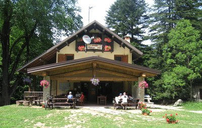
From Pian del Lupo, you will head up to Col de Porta Sestrera (2225m) heading close to the Rastelli del Marguareis, pointed siliceous outcrops scattered with fir trees. On the col which provides acces to the vast limestone high-plateau, continue along to the following fork in the path, where there is a sign for Havis De Giorgio-Mondovì and the valley of Biecai to the left. Head gently downwards until the ephemeral lake of Biecai, set against the spectacular backdrop of the Cime des Saline and the Pointe Havis De Giorgio. The path continues along to Col de Porta Biecai and then steeply down to the valley below from where, halfway down, you will reach the Havis De Giorgio-Mondovì refuge (1761m), which is located in a magnificent hollow of Pian Marchisa. In the immediate surrounding area, the Pis d'Ellero is visible: in the spring, a spectacular jet of water spurts out of the cavity on the rock face.- Departure : Pian delle Gorre
- Arrival : Havis de Giorgio-Mondovi refuge
- Towns crossed : Chiusa di Pesio
Altimetric profile
Report a problem or an error
If you have found an error on this page or if you have noticed any problems during your hike, please report them to us here: