8. Alto Tanaro Tour, stage 8: from Rifugio Pian dell'Arma to Garessio
Description
Below the Pian dell'Arma Refuge (1339 m), follow the dirt track to the left; go up to the left to a house and follow a path towards the north-east. Go up to the left in a gully, with narrow hairpin bends, to the meadow on the ridge above. Turn left, following the waymarking on the wide ridge among forks in the path and dirt tracks; then by a renovated mountain hut, take the path that branches off to the right and goes up quite steeply to the Colla Bassa.
Turn right (north) following the wide grassy ridge to the summit of Monte Armetta (1744 m, 1:25 hours from Pian dell'Arma Refuge).
From the summit descend to the east through meadows, then the path turns to the south-east and quickly loses altitude reaching the wide basin of Pian del Colle.
Here you enter a small track going right, go to the right again when you meet the next dirt road. The road runs along the edge of a wood, makes a long curve to the left intersected by a shortcut and arrives at Colle San Bartolomeo (1446 m, 0:50 mins from Monte Armetta).
Beyond the road, take the path that goes up to Monte Dubasso; before reaching the summit it turns to the north, returning to the watershed. The path rises and falls along the ridge that leads to Colle del Prione (1297 m, 1:00 hour from Colle San Bartolomeo), where a dirt road crosses.
Take the path in front that climbs steeply to Costa del Prione leading to the foot of very steep ridge of Monte Galero (about 1507 m, 0:55 mins from Colle del Prione).
Leave the branch for Monte Galero to the right, and go left, descending through beech woods to Prato del Poco.
Turn right (east) on an old logging track; to the Rio Bianco valley, devastated by a landslide, take a left on a path that drops down for a long time through beech trees then quickly regains altitude and arrives at the Fontana delle Meraviglie (1174 m, 1:00 hour from the Monte Galero ridge). A little higher up is a dirt road, keep left here, ignoring numerous branches to the left, until you pass the ruins of the Cappella di Sant'Anna and continue the descent to the Colletto di Pennino, a small crossroads where you see the Pilone di Sant'Anna (969 m, 0:35 mins from the Fontana delle Meraviglie).
Turn right onto the mule track that continues into the wood: ignore the turnings on the left for Monte Pietra Ardena and right for Pianchette, the descent continues on a badly eroded stretch. The endless side branches are ignored and finally we arrive at the Ponte dei Corni (642 m, 0:40 mins from the Pilone di Sant'Anna), which leads to the provincial road.
Follow it to the left up to the nearby church: here you turn right into Via Cavour, entering the historic centre of Garessio, Borgo Maggiore. Take Via Cavour, the Provincial Road 213 and Corso Statuto. The stage ends by convention in Piazza Vittorio Veneto, in Borgo Ponte di Garessio (584 m, 0:25 mins from Ponte dei Corni).
- Departure : Rifugio Pian dell'Arma (1339 m)
- Arrival : Garessio, Borgo Ponte (584 m)
- Towns crossed : Ormea and Garessio
Altimetric profile
Transport
Riviera Trasporti Piemonte S.r.l.
Viale Piaggio 38 - 12078 Ormea (Cn)
Telefono Centralino: 0183.7001
Contatti e-mail http://www.rtpiemonte.it/index.php/contatti-azienda
Orari http://www.rtpiemonte.it/Upload/Orari/202.pdf
Access and parking
Report a problem or an error
If you have found an error on this page or if you have noticed any problems during your hike, please report them to us here:
Close by1
- Mountain Hut
Mountain Hut
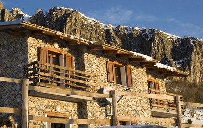
Rifugio Pian dell’Arma 1350 m
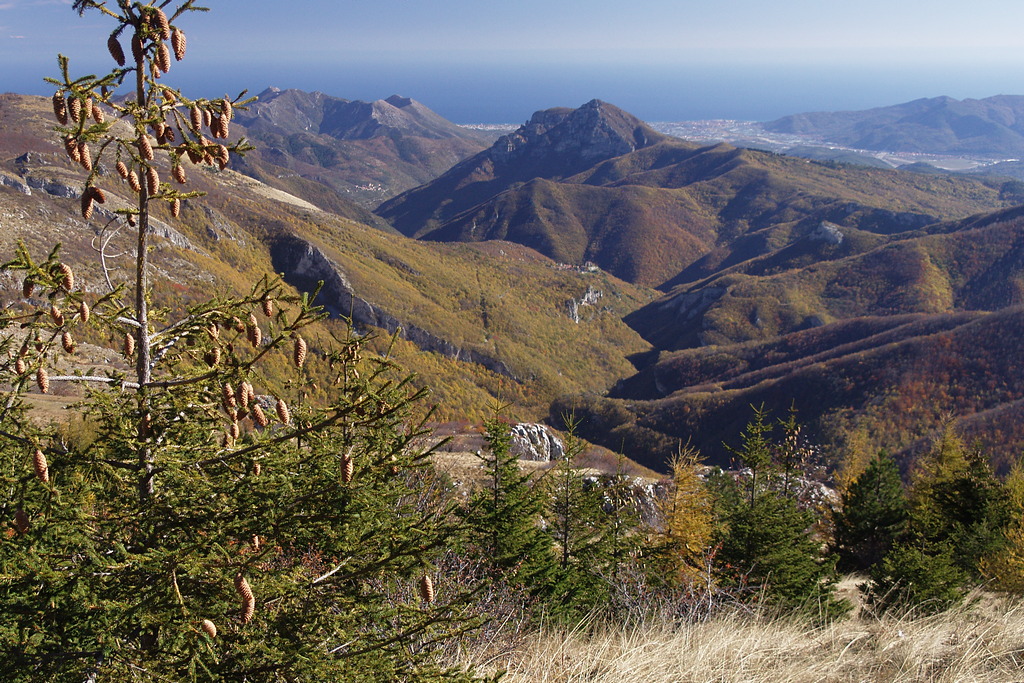
From its 1350 m above sea level, the Refuge offers a breathtaking view of the Ligurian Sea and the cliffs of Rocca dell'Arma. From here, with short walks, the Monte is added
Armetta and the Madonna della Guardia, from which the view embraces the Marguareis Natural Park, the splendid beginning of the western Alpine arc.