5. Alto Tanaro Tour, stage 5: from Rifugio Don Barbera to Upega
1 point of interest
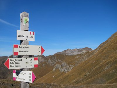
Palina segnaletica al Colle delle Selle Vecchie - Archivio EAM  Cross-border
The Colle delle Selle Vecchie
This was an important pass in past ages, probably on one of the salt routes, it was widely used by the shepherds from Briga in their transhumance towards the pastures at the foot of the Marguareis Massif.
The place name refers to the "selle", or "cellars" for the preservation of cheeses, once evidently present in the surrounding area. The cellars are generally stone buildings, with a barrel vault, covered and insulated with grass clods to ensure constant temperature and humidity inside.
[A. Parodi, R. Pockaj, A. Costa - Nel cuore delle Alpi Liguri, collana Sentieri e Rifugi, Andrea Parodi Editore, 2012, p.34]
Description
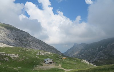
From the Don Barbera Refuge (2079 m) follow the dirt road that heads to the nearby Colle dei Signori, but leave it almost immediately to take a path to the left.
The path crosses the road to Monesi and then continues as a mule track to the slopes of the Cime de Seneca. Arrived at a panoramic col, the
mule track veers to the left along the slopes of Cima di Pertegà and then descends to Colle delle Selle Vecchie (2097 m, 0:50 mins from Rifugio Don Barbera).
Staying on the ridge, after a series of ups and downs you arrive at Colle del Vescovo (2162 m, 0:25 mins from Colle delle Selle Vecchie).
The mule track rises up close to the summit of Cima di Vélega, then descends to a pass, where it is reduced to a path; keep to the left of the watershed, losing
altitude to skirt around Monte Bertrand, then continue the descent to Colla Rossa (2172 m, 1:30 hours from Colle del Vescovo).
At the pass you crosses the less evident path that connects Upega to Morignole. Follow it to the left, using the waymarking through the larch forest, Bosco delle
Navette. Once you reach the wide ridge, the path goes straight down to Poggio del Lagone (1897 m, 0:30 mins from Colla Rossa).
At this crossroads, ignore the road to the far-off Colle di Tenda and take the dirt road, ahead and slightly to the left, heading north. Passing a track to the right
for Upega the road comes to the gate of the Case dei Cacciatori (1835 m).
Follow the fence (private property) round to the left. Once you have picked up the path again, go back to the ridge in the larches and drop quite steeply; you
ignore various crossroads (signposted) and finally enter a mule track, which you follow to the right.
The mule track, steep and rough, loses altitude quickly: after two tight bends, with Upega now in sight, the mule track (sometimes not evident) leads to the
Chapel of the Madonna della Neve and to the provincial road. Following the road to the left, go down to Upega. If you want to avoid the tarmac, go up to the
right for a few yards and then take a non-marked grassy mule track to the left. Following the occasional waymarking signs, go past the junction on the right for
Poggio del Lagone and descend to the main road. Following it to the right, you will soon reach Upega (1280 m, 1:25 hours from Poggio del Lagone).
- Departure : Rifugio Don Barbera (2079 m)
- Arrival : Upega (1280 m)
- Towns crossed : Briga Alta, La Brigue, and Tende
Altimetric profile
Recommandations
Access and parking
Report a problem or an error
If you have found an error on this page or if you have noticed any problems during your hike, please report them to us here: