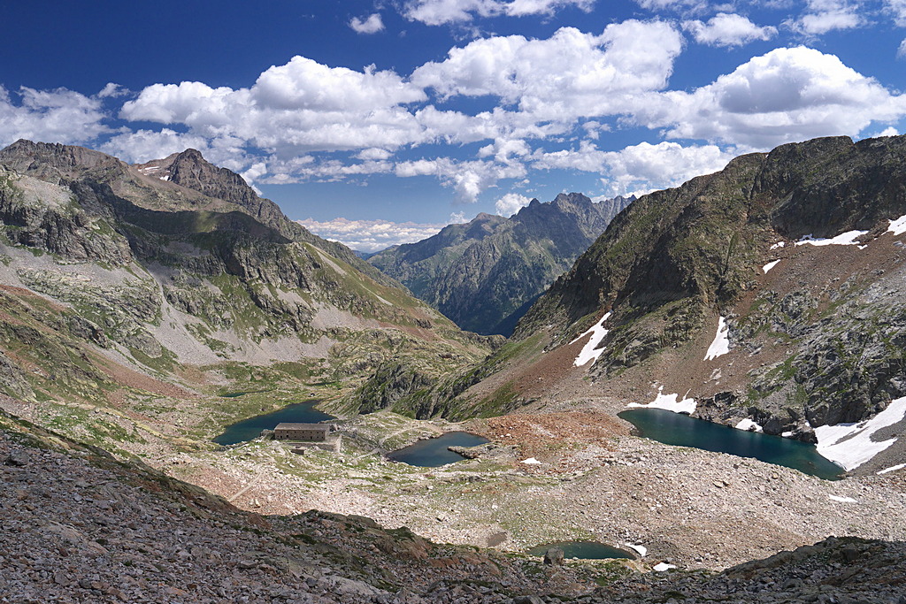
The Valscura lakes and the Bassa del Druos pass
6 points of interest
Il Lariceto - Cati Caballo  Flora
FloraThe larch
This type of forest is rather localized in the Maritime Alps, which notoriously represent the realm of the beech forest. It covers the slopes at the heads of the valleys with sparse and luminous populations, sometimes grazed by the herds that have climbed the mountain pastures. Most of the time their purity is not natural, but induced by man: in fact, over the centuries, man has favored this tree species to the detriment of others, such as the stone pine, for example, because they are less favorable for exercising the grazing due to the increased shading of the soil.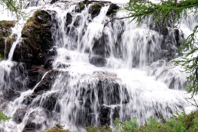
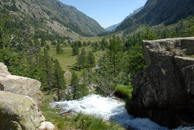
La cascata all'imbocco del Pian del Valasco - Roberto Pockaj  Geology
The Pian del Valasco waterfall
The mass of rocks over which the water falls is a typical example of a glacial rock step. During the glaciations it formed the lower limit of the lake at the foot of the glacier. A tongue of the glacier extended beyond the step.
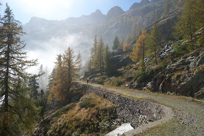
Un tratto della strada ex militare "Pian del Valasco - Lago inferiore di Valscura" - Roberto Pockaj  History and historical trail
Former military road 452
Starting at the fork near the Valasco Refuge, the route follows former military road 452 "Pian del Valasco - Lower Lake Valscura", built in the early thirties to serve the Valscura defense system. In order to make it possible to drive transport vehicles on the road, which was not much more than a wide mule track, much of the 1909 military road had to be expanded, being too narrow to meet the new needs.
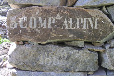
Iscrizione su un cantonale di un ricovero ottocentesco al Lago inferiore di Valscura - Roberto Pockaj History and historical trailThe Valscura Barracks
Since the end of the eighteen hundreds(an inscription on the remains of a shelter reads "3° Compagnia Alpini, 1888") Lower Lake Valscura was chosen as the site where troops were garrisoned to defend the strategic pass of Bassa del Druos. Beginning in 1888, when barracks were erected to house 140 soldiers and two officers, for almost fifty years buildings were constructed on this site, until the entire complex was finally transformed into an armory, officially known as A131,containing munitions, explosives and artillery pieces.
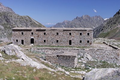
La caserma del Druos ai Laghi superiori di Valscura - Roberto Pockaj History and historical trailThe Massimo Longà Barracks
The barracks are named for Massimo Longà, Captain of the Alpine Corps, who died on Monte Ortigara on 10 June 1917 (to be precise, on an Army Corps of Engineers map, the Rifugio's name is indicated as Massimo Mongà, differently from the inscription on the plaque over the main entrance). The barracks building is an imposing structure, built, according to documents of the Engineering Corps, in 1903. Other sources give the date of its construction as between 1916 and 1917, thanks to the forced labor of Austrian prisoners captured on the Eastern front, but if the Engineering Corps documents can be believed, it is more probable that the barracks were only restructured during the WWI years.
La visuale da una delle gallerie che ospitavano la Batteria del Druos - Roberto Pockaj History and historical trailThe Druos Artillery Battery
Near the Bassa del Druos there are the ruins of a shelter and the Druos Battery, a defensive military gun emplacement in a cave of the Vallo Alpino. The artillery battery, realized with minimum investment in the mid-thirties, consisted of 4 100/17 howitzers captured from the Austrians in WWI. The guns were positioned in the cave without any shielding whatsoever: there wasn't even a command room inside. Two of the 4 galleries where the cannons were placed can still be seen clearly, but the entrances to the other two have been obstructed by landslides.
Description
The route begins to the side of the parking lot above Terme di Valdieri (1385 m), following the unpaved former military road that leads up to the Pian del Valasco, just as in the itinerary named "The Pian del Valasco and the Valasco Refuge" {->09}. At the fork in the dirt road (1763 m, 1 hour and 10 minutes from Terme), instead of taking the left fork, which leads to the Valasco Refuge, the route follows the path on the right.
The road reaches the upper Pian del Valasco, and passes by the turnoff for the Colletto del Valasco on the left, then climbs in a series of switchbacks through a sparse patch of larches. Near an enormous larch there is the turnoff for the Questa Refuge, but this itinerary passes it by and continues on along the road.
The road goes by the foot of a small waterfall and a little ways further on forks: the two paths meet again further uphill, but by continuing straight on hikers can enjoy walking a spectacular tract through a tunnel in the rock.
The road then straightens out along the bottom of a narrow valley, passes by the mule track for Colle di Valmiana on the right and finally reaches Lower Lake Valscura (2265 m, 2 hours and 5 minutes from the Pian del Valasco).
The route passes by the turnoff on the left for Lake Claus and, after crossing over the runoff stream, also passes by the path on the right for the Colletto di Valscura.
The route continues on a comfortable mule track that winds alongside the lake and over a hillock before entering a wide detritic bowl, the site of the Upper Valscura lakes (2458 m, 40 minutes from Lower Lake Valscura) and the Druos barracks.
The mule track snakes through the depression, with the lakes on its left and the barracks to the right, then climbs up the steep detritic slope at the uphill end of the bowl and comes to the Bassa del Druos pass (2628 m, 30 minutes from the Upper Valscura lakes).
- Departure : Terme di Valdieri (1385 m)
- Arrival : assa del Druos (2628 m)
- Towns crossed : Valdieri
Altimetric profile
Recommandations
Transport
SNCF line TER Provence Alpes-Côte d'Azur For travel in the PACA region and towards Cuneo www.ter-sncf.com/pac
Trenitalia for travel in the Piedmont region https://www.trenitalia.com/it.html
Access and parking
Parking :
Report a problem or an error
If you have found an error on this page or if you have noticed any problems during your hike, please report them to us here:
Close by2
- Mountain Hut
Mountain Hut
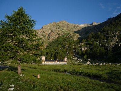
Rifugio Valasco
At the center of the Valasco plateau stands the beautiful Palazzina Reale di Caccia, commissioned by Vittorio Emanuele II for his chamois hunting and for some years now it has become an accommodation facility.
The Valasco Refuge, in the heart of the Alpi Marittime Park, stands at 1764 m in Valle Gesso, Terme di Valdieri (CN). - Mountain Hut
Mountain Hut
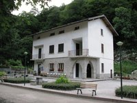
Rifugio posto tappa Gta "Savoia"
The Casa Savoia refuge (GTA stopover) is located in Terme di Valdieri, in the heart of the spa area, at 1,368 meters above sea level. It is located along the itinerary of the Great Crossing of the Alps and is the starting point of numerous excursion itineraries.