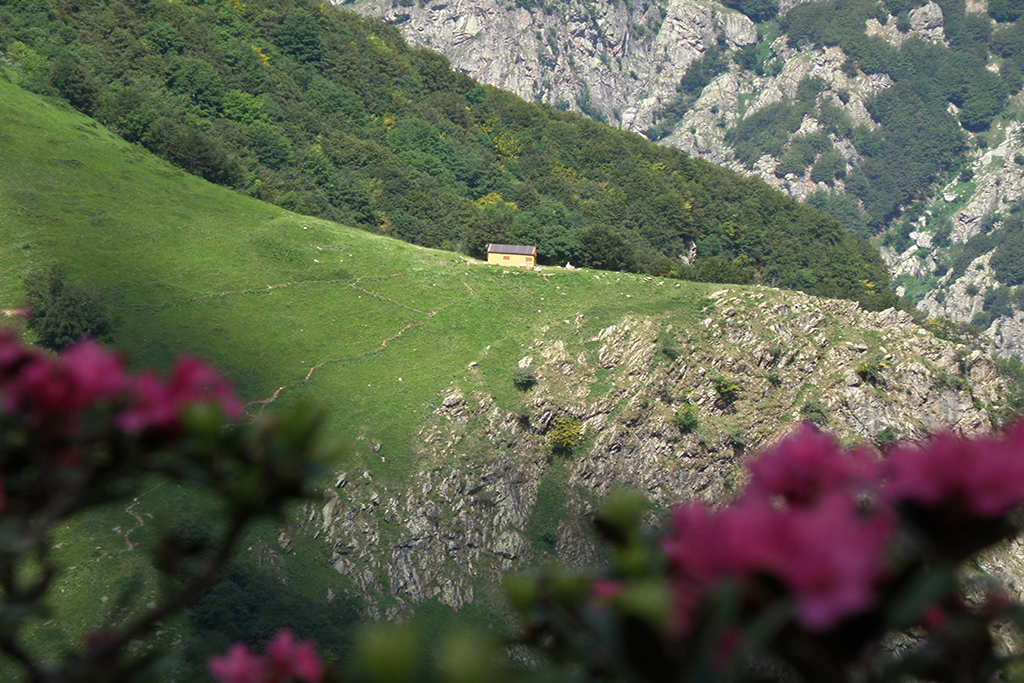
The Barbero Community Hut
The route passes through a number of habitats, from woods to mountain grazing grounds. The grassy hillock on which the Barbero community hut is located is often visited by groups of chamois. The lower Gias della Vagliotta, still in use, is the place where delicious cheeses are made.
3 points of interest
La faggeta - Cati Caballo  Flora
FloraThe beech forest
The beech forest is a widespread wood because in this alpine sector, close to the sea, it finds sub-oceanic climatic conditions, favorable to its affirmation. Thanks to the limited temperature ranges and the good level of humidity in the air, beech becomes very competitive with other wood species. The purity of its populations, however, is also due to the action of man, who has favored this species, a source of excellent fuel, to the detriment of the silver fir.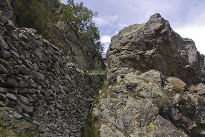
Un muretto della vecchia mulattiera di caccia dei Savoia - Nanni Villani  History and historical trail
The hunters' mule track and the ice quarry
Just beyond the walkway near the lower Gias della Vagliotta, about thirty meters to the left of the path, it isn't hard to pick out an old mule track that climbs up, to no apparent destination, among the heights of the Asta Sottana. In point of fact, the mule track served a dual purpose: it led to a hunting blind and the nearby semi-permanent snowfield, which, when the royal family spent their summers in the valley, was the source of the ice used to preserve food and cool the beverages enjoyed by visitors to the Hot Springs.
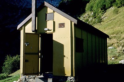
Il Bivacco Barbero - Roberto Pockaj History and historical trailThe Barbero community hut
The Barbero Bivouac, now a community hut, was inaugurated by the Cuneo chapter of CAI on 22 August, 1965. It is named for Roberto Barbero, a young climber from Cuneo who fell to his death from the Cima Plent in the Catena delle Guide on 16 June,1963.
Description
After crossing the Ponte della Vagliotta bridge(1093 m), the path begins in the beech wood, slightly to the right of the bridge.
The path climbs up the Vallone della Vagliotta valley gently at first, with long switchbacks through the beeches on a comfortable mule track. Winding through the woods for a long tract, the path remains on a gentle incline. Some slightly tighter switchbacks precede its entry in a narrow defile whose walls plunge down to the Rio della Vagliotta torrent below. The path leads across the ravine on the orographic left and proceeds in tight hairpin turns along a rocky slope with low scrub vegetation.
After crossing the torrent on a pretty wooden bridge, the path rises up a grass-covered detritic slope, with numerous switchbacks and beautiful vistas of the little pocket valley below.
Passing by a small waterfall on the right, the path continues on with switchbacks (often cut by shortcuts, sometimes more clearly marked than the main trail) until it reaches a second picturesque waterfall.
A bit further on, the path enters a broad bowl-shaped meadow, which it runs through until the fork, a few dozen meters before the recently constructed lower Gias della Vagliotta. Ignoring the left fork, which leads to the Costi Bivuoac and the Barra della Vagliotta pass, hikers follow the right fork, to the Barbero Community Hut. The path almost immediately comes to a wooden footbridge, crossing the Rio della Vagliotta for the third time, and then, cutting back on itself, veers to the northwest, heading towards the grassy hilloock atop which lies the Bivouac.
After a brief tract with an imperceptible incline, the trail reaches the base of the hillock. At the left end of the second switchback, the trail forks: it's advisable to avoid the clearly marked (but very steep) shortcut to the right and stay on the left branch, which leads, after two long uphill traverses, to the Barbero Community Hut(1669 m, 1 hour and 55 minutes from the Ponte della Vagliotta bridge).
- Departure : Vagliotta bridge (1093 m)
- Arrival : Barbero Community Hut (1669 m)
- Towns crossed : Valdieri
Altimetric profile
Recommandations
Transport
SNCF line TER Provence Alpes-Côte d'Azur For travel in the PACA region and towards Cuneo www.ter-sncf.com/pac
Trenitalia for travel in the Piedmont region https://www.trenitalia.com/it.html
Access and parking
Drive from Borgo San Dalmazzo up the Gesso valley. After passing Valdieri, continue on in the direction of Terme. After passing Sant'Anna, park in the parking lot on your right, near the Ponte della Vagliotta bridge (just beyond the Tetti Gaina hamlet).
Parking :
Report a problem or an error
If you have found an error on this page or if you have noticed any problems during your hike, please report them to us here: