Lake Vei del Bouc
Around the shores of the lake, in addition to lovely grassy meadows on which to rest, there are also some spectacular sheepbacked boulders, evidence of the presence of glaciers in ancient times. Until recently, it was possible to see primitive incisions made on the rocks around the lake, probably of the same origin as the far more famous ones in the Valle delle Meraviglie.
4 points of interest

La Palazzina Reale di Caccia di San Giacomo - Roberto Pockaj  History and historical trail
The former Royal Hunting Lodges
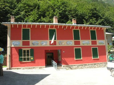
The two large buildings, now owned by religious groups, are said to have been built between 1865 and 1870 at the behest of Vittorio Emanuele II, to be used during his sojourns in the Royal Hunting Reserve. The one on the left, with its attractive portico decorated in horizontal stripes with the colors of the House of Savoy, was the residence of the royal entourage, while the other housed the stables.
The stables were then given to the army, which expanded the building between 1897 and 1898, transforming it into the Princess Elena barracks.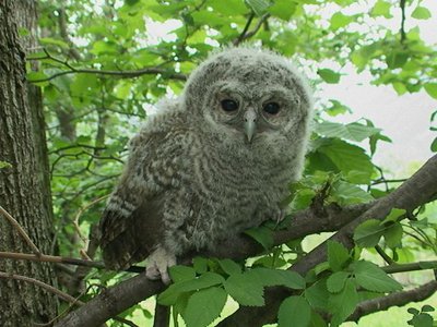
Allocco - Augusto Rivelli  Fauna
FaunaThe tawny owl
Among nocturnal birds of prey, the owl plays an important role, both from an ecological point of view and in the human imagination. It is in fact one of the most widespread species and therefore responsible for controlling the populations of rodents in wooded areas. For our part, often confused with the owl due to its shrill calls, it has a typical song that anyone recognizes: the typical mournful owl song. It can be recognized from owls and owls by the color of its eyes: the iris is completely dark.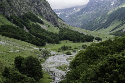
PIAN DEL RAZUR - gianluca.giordano  Geology
The Pra del Rasur
The ample meadow of the Pra del Rasur was formed towards the end of the last Ice Age, when rockslides from both sides of the valley blocked the course of the torrent. The detritus carried by the torrent itself, still quite impetuous today, gradually filled up the basin that was formed, thus creating the flat area.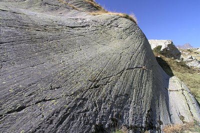
Le rocce montonate, uno dei segni più evidenti della presenza dei ghiacciai in epoche passate - Roberto Pockaj History and historical trailPrehistoric petroglyphs
Until recently, some petroglyphs were traceable on the rocks around the lake. The subject of an investigation by the Archaeological Superintendency of Piedmont in the years 1989/90, engravings depicting horns, weapons and geometric figures were identified. They should be attributable to the much more famous and numerous ones of nearby Monte Bego, and date back to the second half or end of the 4th millennium BC.
Today they have virtually disappeared.
Description
A few dozen meters downstream from San Giacomo di Entracque (1,209 m), you cross the bridge over the Gesso della Barra Stream. You ascend into the Moncolomb Valley, following the same route as the “Pra del Rasur and Gias sottano del Vei del Bouc” trail, up to the Gias sottano del Vei del Bouc (1437 m, 1 hour 10 minutes from San Giacomo).
Here the dirt road ends and forks into two mule trails: ignore the one on the right leading to the Pagarì Mountain Hut, and take the one on the left toward Lake Vei del Bouc.
The mule trail climbs gently in switchbacks up the side of the valley, passing twice through a small beech grove, and reaches the entrance to the Vei del Bouc Valley.
Now on a trail, you cross in a southeasterly direction, pass over a stream, and resume the very long series of wide switchbacks along the sun-drenched ridge.
At an elevation of around 1840, at a left-hand hairpin turn, ignore the trail to the right (marked by a stone cairn) and stay on the main trail.
After a few more turns, you’ll follow a long traverse heading southeast, interrupted only by two short hairpin turns. After merging with the aforementioned alternate route from the right, you’ll immediately come to a fork: do not turn right, as the original route would have you do, because the footbridge over the lake’s outlet has been destroyed; instead, keep left, heading toward Colle del Vei del Bouc.
A short distance beyond this point, the trail splits again; take the right fork, which is a recently opened branch. The trail descends slightly and changes direction to cross the lake’s outlet via a stone-lined ford. Once you rejoin the original mule trail, continue to the left to reach Lake Vei del Bouc (2042 m, 1 hour 55 minutes from Gias sottano del Vei del Bouc).
On the meadows near the lake, you’ll find a park ranger’s hut.
- Departure : San Giacomo di Entracque (1210 m)
- Arrival : Lake Vei del Bouc (2042 m)
- Towns crossed : Entracque
Altimetric profile
Recommandations
Access and parking
From Borgo San Dalmazzo drive up the Valle Gesso. After passing Valdieri, turn left for Entracque. Before reaching the town, turn right toward San Giacomo; then, after the dam, follow the signs to the left for San Giacomo. Parking is available for a fee during the summer season.
Report a problem or an error
If you have found an error on this page or if you have noticed any problems during your hike, please report them to us here:
Close by2
Mountain Hut
Rifugio escursionistico S. Giacomo e Baita Monte Gelas 1226 m
The Monte Gelas Mountain Hut was founded in 1953 by Giovanni Gerbino and Caterina Mellano. Since then, the Gerbino family has been offering hospitality and refreshments to visitors to the upper Gesso Valley, while also managing the adjacent San Giacomo Hiking Hut.