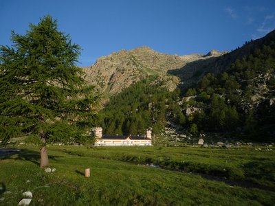
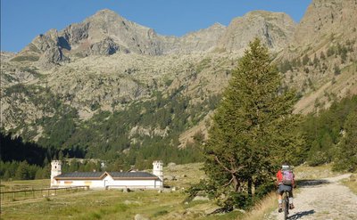
The Pian del Valasco plateau and the Valasco Refuge
The Piano del Valasco is a large grassy plateau, which was originally a lake basin, now filled in. It is ringed by peaks around 3,000 high and crossed by a sinuous torrent. In the middle of the plateau stands the Royal Hunting Lodge, which Vittorio Emanuele II had built for his chamois hunts, now a refuge.
2 points of interest
Tête du Claus (2897m), surplombant le refuge de Valasco en été - A. Rivelli / PNAM  History and historical trail
Refugio Valasco, former hunting lodge
This is where King Victor Emmanuel II of Italy had a hunting lodge built, a singular “castle”, square in shape and with a crenelated tower. It has since been transformed into a high-altitude refuge, much to the delight of hikers.
From the Valasco plateau where the refuge is located, you can easily reach the area of the Valascura lakes, heading along the magnificent road built by hunters in the early 20th century. Part of the road is paved, allowing you to go through an area which is littered with boulders and debris.
A mule track leads to the panoramic col of Valmiana.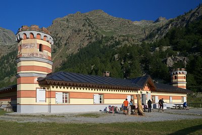
Il Rifugio Valasco - Roberto Pockaj History and historical trailThe Valasco Royal Hunting Lodge
The construction of a "Country House" in Vallasco, which Vittorio Emanuele II would later utilize for his hunting parties in the Royal Reserve, dates back to the years after 1868, when there were probably four buildings standing on the plateau. However, the Royal Hunting Lodge, at least the one we admire today, was probably built after 1873, although sources differ on this.
Its history has been turbulent, and marred by a series of fires until, following an important restructuring by its current owner, in 2008 it was transformed into an alpine refuge.
Description
On the right side of the parking entrance above Terme di Valdieri (1385 m), a former military road, unpaved, leads westward, up the Vallone del Valasco, through lovely deciduous woods and then, as the road climbs, more larches. After a long straight stretch, on the first switchback to the right, there is a clearly visible path on the left (unmarked!) that leads to the lower Piano del Valasco.
The trail continues on near the torrent, cutting across the many switchbacks of the former military road and crossing it many times, the first near the right side of a switchback at an altitude of about 1600 meters, then again to the right of another switchback at about 1625 m.
It then joins the road on a straight stretch at about 1650 m. At this point, after a few dozen meters along the former military road, the route leaves the road and follows the trail to the left.
In this stretch of the route, there are evident traces of the mule track used before the road was built.
The route rejoins the unpaved military road definitively at an altitude of ca. 1705 m, facilitated by the recent addition of steps, and follows the road to the left. There is a ford crossing a small rivulet that flows over the road (the rivulet swells into a stream in springtime) and leaving behind the trail for Colle di Valmiana on the right, the route passes a small spring and comes to the waterfall marking the entrance to the lower Piano del Valasco (1763 m, 1 hour and 10 minutes from Terme di Valdieri).
The military road leads to the center of the large meadow, formed by the basin of a glacial lake and now completely filled in, and forks: the right fork heads for the upper Piano del Valasco and the Valscura Lakes, while the left one leads to the Valasco Refuge (1763 m, 5 minutes from the lower Piano del Valasco), once the Royal Hunting Lodge of the House of Savoy.
The return journey follows the former military road crossed numerous times on the way up: the road leads gently downhill, after a number of long traverses and a series of switchbacks. At an altitude of about 1500 m, next to a switchback to the right, half-hidden by the vegetation, there is a fortified bunker that was part of the Vallo Alpino defenses, just a few meters uphill from the road.
At the next elbow turn, the road links up with the trail used on the way up, and leads back down to the parking lot above Terme di Valdieri (1385 m, 1 hour and 1 minutes from Rifugio Valasco).
- Departure : Terme di Valdieri (1385 m)
- Arrival : Valasco Refuge (1764 m)
- Towns crossed : Valdieri
Altimetric profile
Recommandations
Transport
Regular line Cuneo, Valdieri, Entracque
Tel: 00 39 (0) 171 69 29 29
www.benese.it
SNCF TER Provence Alpes-Côte d'Azur line
For travel in the PACA region and to Cuneo
www.ter-sncf.com/pac
Trenitalia to travel in the Piedmont region
https://www.trenitalia.com/it.html
Access and parking
Drive up the Valle Gesso from Borgo San Dalmazzo. After passing Valdieri, continue on until you reach Terme. There is a parking fee during the summer season.
Parking :
Accessibility
- Emergency number :
- 114
Report a problem or an error
If you have found an error on this page or if you have noticed any problems during your hike, please report them to us here:
Close by2
- Mountain Hut
Mountain Hut
Rifugio Valasco
At the center of the Valasco plateau stands the beautiful Palazzina Reale di Caccia, commissioned by Vittorio Emanuele II for his chamois hunting and for some years now it has become an accommodation facility.
The Valasco Refuge, in the heart of the Alpi Marittime Park, stands at 1764 m in Valle Gesso, Terme di Valdieri (CN). - Mountain Hut
Mountain Hut
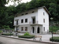
Rifugio posto tappa Gta "Savoia"
The Casa Savoia refuge (GTA stopover) is located in Terme di Valdieri, in the heart of the spa area, at 1,368 meters above sea level. It is located along the itinerary of the Great Crossing of the Alps and is the starting point of numerous excursion itineraries.