On the Adus plateau
3 points of interest
Le lac des Adus, (2130 m), en contre-jour - RICHAUD Philippe  Geology
Granite
The path toys with the edge of the plateau made of heavily eroded granite. The gravelly slopes are the result of this erosion (decomposed granite). Scotch pines and mountain pines cling on to this steep slope.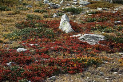
Buissons de myrtilles rougis en tout début d'automne (Vaccinium myrtillus). - ICARDO Emmanuel  Flora
FloraBlueberries and rhododendrons
A moorland area of blueberry bushes and rhododendrons which illuminate autumn with a riot of colours. The blueberry, which is actually a bluish-purple colour, is sweet and is the only plant which needs aluminium-rich soil. The rhododendron, provides a wide range of colours, from pink to white via carmine, violet or orange and it prefers acidic soil.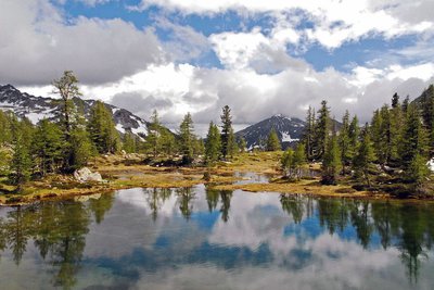
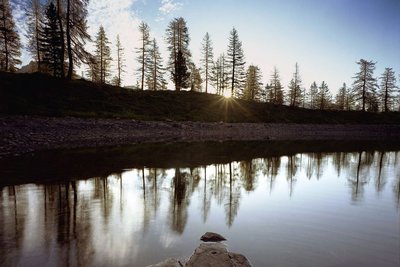
Reflets de nuages dans le lac de Graveirette, (2239 m), le mont Arch la cime de la vallette des Adus, (2449 m) - GUIGO Franck  Lake
LakeLac des Adus
Overlapping between the Salèse valley and Valdeblore, Lac des Adus is perched on a plateau covered in rhododendrons and blueberry bushes at 2140m altitude. Sheltered beneath the slopes of Cime de la Vallette, in summer its level falls gradually as it is only supplied with water by melting snow.
Description
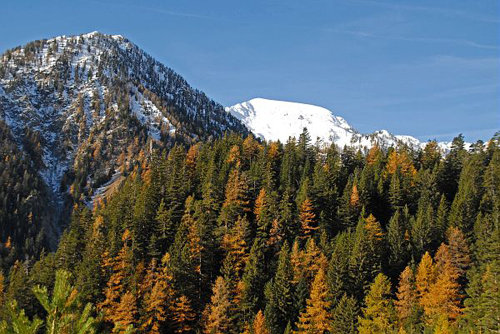
The departure point is marker 434 and the path runs along GR52 (red and white markers) which heads up the Salèse valley, passing successively through fir, Scotch pine and finally larch forests.
At marker 435, follow the path for 200m until the Col de Salèse. The latter is bordered on its left-hand side by a slope which, 50 years after this route was created, is beginning to be taken over by moorland shrubs and bushes.
At marker 436, turn left towards the Lac des Adus. The path passes close to the border of the plateau, made up of heavily eroded granite. The sandy slopes are the fruit of this erosion.
At marker 437, turn left towards the Lac des Adus. As you climb higher, you will leave the forested areas and a vast panorama over the high summits will become visible.
The path then heads downwards in stages towards the Lac des Adus.
After passing close to the refuge located between markers 395 and 396, the path heads down into the denser subalpine forest before linking back up with the carpark which was the starting point of the hike.
- Departure : Carpark at Salèse, marker 434
- Arrival : Carpark at Salèse, marker 434
- Towns crossed : Saint-Martin-Vésubie and Valdeblore
Altimetric profile
Recommandations
Information desks
Maison du Parc national du Mercantour - Saint-Martin-Vésubie
8, Avenue Kellermann - Villa Les Iris, 06450 Saint-Martin-Vésubie
Horaires
Ouvert tous les jours sauf le dimanche du 15 juin au 15 septembre
Office de Tourisme Métropolitain - Bureau d'information de Saint-Martin-Vésubie
Place du Général de Gaulle, 06450 Saint-Martin-Vésubie
Horaires
Ouvert toute l'annéeOffice de Tourisme Métropolitain - Bureau d'information de Valdeblore - La Colmiane
La Colmiane, 06420 Valdeblore
Horaires
Toute l'année.Fermetures exceptionnelles les 1er janvier, Lundi de Pâques, Jeudi de l'Ascension, Lundi de Pentecôte, 1er mai, 8 mai, 14 juillet, 15 août, 1er novembre, 11 novembre et 25 décembre.
Transport
Minibus from St - Martin-Vésubie.
Information available at St - Martin-Vésubie Tourism Office: 04 93 03 21 28.
Access and parking
From the village of Saint-Martin-Vésubie, take the M2565, then the M89 towards Boréon. After the lake and the bridge which crosses the Boréon mountain stream, turn left a few kilometres further on.
You can leave your vehicle at the Salèse carpark, the entrance to the National Park.
Parking :
More information
Report a problem or an error
If you have found an error on this page or if you have noticed any problems during your hike, please report them to us here: