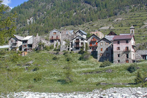
Mollières Valley
Description
After 3km of dirt track running alongside the Tinée and then the mountain stream of Mollières, marker 260 is placed at the foot of the Mollières path, close to the water inlet for the micro-hydroelectric plant. Take the old mule track. Go past a footbridge on the right which leads up into the Vélail valley. The path climbs in a steady gentle slope, hemmed in by the impressive rocky bulk of the Cayre Frémus (2550 m).
The view then opens up along the crest of the Aiguilles du Giegn. The path continues into a wetland area and then climbs the right-hand side of the valley towards the Mollières waterfall. Then head across the scree formed by the Vallette Valley’s alluvial cone.
You will then reach the hamlet of Mollières,then end of the journey at 1572m in altitude.
Follow the same route for the return journey.- Departure : Pont de Paule, Roure
- Arrival : Hamlet of Mollières, Valdeblore
- Towns crossed : Saint-Sauveur-sur-Tinée, Rimplas, and Valdeblore
Altimetric profile
Recommandations
Information desks
Office de Tourisme Métropolitain - Bureau d'information d'Isola 2000
Immeuble Le Pélevos, 06420 Isola 2000
Office de Tourisme Métropolitain - Bureau d'information de Roubion
Mairie de Roubion, le village, 06420 Roubion
Access and parking
Set off from the gate at Mollières bridge, where the Valabres EDF electrical plant is located, after the hamlet of Pont-de-Paule headingtowards Isola.
There is a parking area close to the fence on the right bank of the Tinée. Marker 259, which denotes the itinerary, is on the other side of the bridge.
Parking :
Report a problem or an error
If you have found an error on this page or if you have noticed any problems during your hike, please report them to us here:
