Vens Lakes via Tortisse
1 point of interest
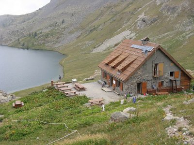
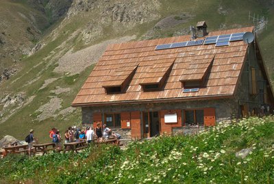
Refuge de Vens - CAF / DR  Refuge
Lac de Vens and refuge
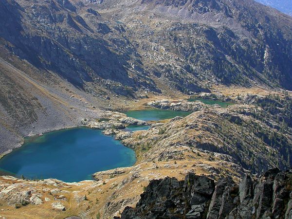
The Vens refuge only has a warden during the summer months. In winter, only one room is open to allow hikers to shelter. The Vens refuge overlooks a series of lakes of the same name. These lakes are of glacial origin, they are the result of a long erosion process by glaciers. The lake below the refuge (the biggest) is 31 metres deep. Ibex, chamois, mouflons and golden eagles can often be seen at the site. Very close to the refuge, you can see the endemic plant which was for a long time the symbol of the Mercantour National Park: Saxifraga florulenta.
Club Alpin Français: Capacity: 45 in summer and 30 in winter (no warden)
Reservations only be e-mail in summer: http://refugedevens.ffcam.fr/reservation.html
No shower, meal included
Description
From Le Pra (1700m, marker 32), which you can drive to, follow the zigzagging path which overlooks the road before reaching the peaceful Morgon plateau and its old metal footbridge. Head through the larch forest and then a narrow section, denoted by marker 33, which provides access to the Tortisse Valley and to the forest houses (2252m) via a long stony passage. At marker 34, with a view over the Aiguilles de Tortisse, branch off to the right and take a good-quality path, which is often in the shade, to a narrow section which has no name, overlooking the Vens Valley (2422m). An airy path, which goes via an intersection at marker 23, leads to another narrow section (2409m) overlooking the large lake of Vens Supérieur. The refuge of the same name (2380m) can be seen at the other end of the lake above the waterfall.
Follow the same route for the return journey. At marker 23, you can also, if the weather is not too hot, head down more quickly via the Vens valley and get back to the starting point of the itinerary.
- Departure : Le Pra
- Arrival : Vens refuge
- Towns crossed : Saint-Étienne-de-Tinée
Altimetric profile
Recommandations
Information desks
Maison du Parc national du Mercantour - Saint Etienne de Tinée
Quartier de l’Ardon, 06660 Saint-Etienne de Tinée
Du 01/06 au 01/07/2022, tous les mardis, mercredis, jeudis, vendredis et samedis de 10h à 19h.
De 10h à 12h et de 14h à 19h.
Du 02/07 au 31/08/2022, tous les mardis, mercredis, jeudis, vendredis, samedis et dimanches de 10h à 19h.
De 10h à 12h et de 14h à 19h.
Du 01/09 au 30/09/2022, tous les mardis, mercredis, jeudis, vendredis et samedis de 10h à 19h.
De 10h à 12h et de 14h à 19h.
Access and parking
Parking :
Report a problem or an error
If you have found an error on this page or if you have noticed any problems during your hike, please report them to us here:
Close by1
- Mountain Hut