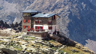
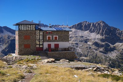
The Remondino Refuge
The Refuge is in an austere spot, with the peaks of the Argentera Massif, over 3000 meters tall, looming behind it, but enjoys a stunning panoramic view of the Vallone della Valletta.
1 point of interest
Il Rifugio Remondino - Roberto Pockaj  History and historical trail
The Remondino Refuge
The Refuge is named for Franco Remondino, Jr. Lieutenant of the Alpine Corps and budding local climber, who died during an ascent on the Rocca Gialeo. A half-barrel bivuoac shelter that sleeps 12 was erected in his memory and inaugurated in 1934. It was later decided to build a real refuge on the spot, in masonry, erected thanks mostly to the financial sponsorship of the Saluzzo Battalion of the Alpine Corps, the Taurinense Division of the Army Corps of Engineers and the 1st Airborne Brigade and inaugurated in 1965. Additional restructuring and extensions were completed in the year 2000.
Description
Pian della Casa can be reached by car, but those who do not intend to drive along the slightly bumpy stretch of dirt road that goes from Gias delle Mosche to Pian della Casa del Re, where the path starts, are forced to move on foot.
Leave the car at the Gias delle Mosche car park (1592 m) and continue along a short stretch of asphalt. The road then becomes a dirt road and goes up the Vallone della Valletta, first between larches and firs, then between pastures, pines and sparse larches. In correspondence with a slightly steeper uphill section, the surface becomes asphalted again and remains so up to the vicinity of a recently renovated mountain pasture, the Gias Nuovo della Casa.
Ignoring the short detour to the right that leads to gias, keep on the main dirt road as far as the entrance to Pian della Casa del Re (difference in altitude: +143/-0 m; time: 0:35 hours; difficulty: T).
At the entrance to Pian della Casa del Re (1735 m), ignore the path on the right for Colle di Ciriegia, Colle di Fremamorta and the Fremamorta lakes. Keeping on the dirt road, you skirt the north-eastern edge of the wide plateau, until you meet on the left, the obvious path to the Remondino refuge and Colle del Mercantour.
The path initially remains close to the bottom of the plateau, among junipers and sparse larches, almost parallel to the former military road, then bends to the left (east) and follows the course of the stream.
Leaving a track on the right (which points to the stream that descends from Vallone di Balma Ghilié), you begin a steep ascent with narrow hairpin bends along a rocky ridge; tiring stretches of steps lead to the footbridge that crosses the stream coming from the Vallone dell'Assedras. A few more hairpin bends and you reach the crossroads on the right for Colle del Mercantour.
Neglecting the branch, with a sharp turn to the north the path leads to cross the stream again, then continues the long ascent with numerous hairpin bends between rocks, grass and sparse larches.
A traverse to the south-east leads to the couloir immediately downstream of the refuge, climbed with several steep hairpin bends. After passing a detrital depression at the base of some rocks, take the last steep climb on steps; leave the track for the traverse to the Bozano refuge on the left and, a little further on, still on the left, the track for Passo dei Detriti.
A few meters after the last crossroads you arrive at the Remondino refuge (2464 m, 2:20 hours from Pian della Casa del Re), in a dominant position on a rocky mammoth.
- Departure : Pian della Casa del Re (1735 m)
- Arrival : Remondino Refuge (2464 m)
- Towns crossed : Valdieri
Altimetric profile
Recommandations
Transport
SNCF line TER Provence Alpes-Côte d'Azur For travel in the PACA region and towards Cuneo www.ter-sncf.com/pac
Trenitalia for travel in the Piedmont region https://www.trenitalia.com/it.html
Access and parking
From Borgo San Dalmazzo go up the Valle Gesso. After Valdieri, continue up to Terme. Passing behind the Hotel Terme, go up to the left in the Vallone della Valletta until the end of the road (dirt in the last stretch) at Pian della Casa.
Parking :
Report a problem or an error
If you have found an error on this page or if you have noticed any problems during your hike, please report them to us here:
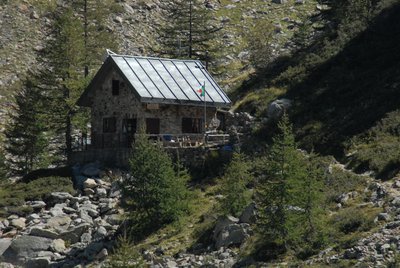
Close by2
- Mountain Hut
Mountain Hut
Rifugio Franco Remondino 2464 m
The mountain hut, owned by the CAI of Cuneo, is named after Franco Remondino, a second lieutenant in the Alpini and a rising star of mountaineering in the Cuneo area who lost his life in 1931, at the age of twenty-one, while climbing the southeast face of Rocca Gialeo with his companion, Lieutenant Erasmo Vivarelli.