The Chiotas dam and the Genova Refuge
The trail winds through rocks and shrubby vegetation until it reaches the Genova Figari Refuge, located between two bodies of water: on one side, the large artificial reservoir of the Chiotas dam, on the other Lake Brocan, a glacial lake. The Chiotas dam, 130 meters high, makes for an imposing sight.
1 point of interest
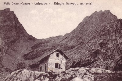
Il vecchio Rifugio Genova - Archivio EAM  Architecture
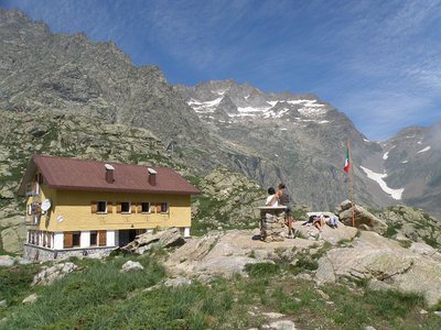
The Genova Figari Refuge
To valorize the hiking trails along the Argentera Massif, in the last years of the nineteenth century the Liguria chapter of CAI decided to build a refuge near the upper Gias del Monighet, in the Vallone della Rovina. The Genova Refuge, as it was named, was inaugurated on 15 August 1898.
But the fate of the first refuge in the Maritime Alps was definitively sealed in 1968: the reservoir of the new Chiotas dam would submerge it permanently. ENEL assumed the task of building another refuge, which was inaugurated in 1981.
The refuge is named for Bartolomeo Figari, who as Secretary General of CAI saw both the successful conquest of K2 and the birth of the National Alpine Rescue Corps, to which he bequeathed all his worldly goods.
Description
The trail begins to the right of the small building at the southern end of the developed area at Lake della Rovina (1545 m).
After a few steps, the trail turns right towards the ENEL cabin and a picnic table. Then, a bit further to the left, the real trail begins.
The trail rises in a series of switchbacks, then turns right and passes over some rocky points with the aid of a few steps. The trail continues with a series of switchbacks and passes over a small rivulet, after which there are some steps beside a narrow detritic channel. Numerous tight switchbacks alternate with occasional steps. The trail continues to climb, more steeply now, still alternating switchback turns and steps until it comes to a fork: to the left, the old trail surmounts a few rocks thanks to a metal ladder, while the right fork rises above them with a few switchbacks (recommended choice) before rejoining the old track. A small rivulet and a final set of steps and the trail arrives at the unpaved road, now unusued, that was used by ENEL vehicles when the dam was built.
The path on the left leads downhill back to the Lake della Rovina, following a different route, less steep but exposed in some tracts and passing through areas with a risk of rockslides from above.
The route follows the road to the right, slightly uphill, and shortly, next to a turn, comes to a paved service road for the dam.
The road, which is closed to private traffic, including on foot, climbs up from Lake della Rovina to the Chiotas dam. The route follows the road to the left for a few hundred meters, then just before the tunnel that passes under the drainage channel, the route takes the turnoff on the left on the dirt path for the Genova Figari Refuge.
The paved road instead continues on to the Chiotas dam, 130 m high, which can be reached in just a few minutes on foot. The walkway on top of the dam, the only access to the Vallone del Chiapous on foot, is open to hikers and is decidedly worth crossing over.
After leaving the paved road, the route follows the dirt road uphill on a fairly steep gradient, at first beside the drainage channel, until it reaches the Colle di Laura dam (1980 m, 1 hour and 15 minutes from Lake della Rovina), from which there is a fine view of the Chiotas reservoir.
An extended up and down stretch runs along the southeast perimeter of the reservoir, passing by the turnoff on the left for Colle di Fenestrelle. One last up and down tract and the unpaved road comes to the Genova Figari Refuge (2009 m, 20 minutes from the Chiotas reservoir).
Very close to the refuge there is another body of water, Lake Brocan, of glacial origin. The lake can be approached directly, without following a trail, or hikers can walk along its western end on a comfortable path.
- Departure : Developed area of the Lago della Rovina (1545 m)
- Arrival : Genova Figari Refuge (2009 m)
- Towns crossed : Entracque
Altimetric profile
Recommandations
Transport
SNCF line TER Provence Alpes-Côte d'Azur For travel in the PACA region and towards Cuneo www.ter-sncf.com/pac
Trenitalia for travel in the Piedmont region https://www.trenitalia.com/it.html
Access and parking
Drive from Borgo San Dalmazzo up the Valle Gesso. After passing Valdieri, turn left for Entracque. There is a turnoff to the right for San Giacomo before arriving in town, and then a turnoff to the left for Lake della Rovina. There is a parking fee during the summer months.
Parking :
Report a problem or an error
If you have found an error on this page or if you have noticed any problems during your hike, please report them to us here: