The Morelli Buzzi Refuge and the Colle del Chiapous
1 point of interest
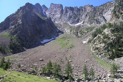
Panorama dai pressi del Lagarot di Lourousa; sullo sfondo al centro il Canalone di Lourousa e, a destra, il Corno Stella - Roberto Pockaj  Lake
LakeThe Lagarot di Lourousa
Springwater, welling up among meadows and larches, forms numerous limpid pools and streams; the water is at times turquoise, at times milky and at others perfectly transparent, making this a particularly striking location, perfect for a contemplative rest. The Canalone di Lourousa, bordered by Monte Stella and the Corno Stella and scoured by the Gelas di Lourousa, lies beyond the plateau of the same name, and a look over one's shoulder yields a view of the imposing outline of Monte Matto.
Description
From Terme di Valdieri (ca. 1353 m) the route leads to the pleasant bowl containing the Lagarot di Lourousa (1971 m, 2 hours and 5 minutes from Terme di Valdieri), along the same trails as for itinerary 18, "The Lagarot di Lourousa" {->18}.
The trail crosses the broad grassy depression, passing by two turnoffs along the valley floor: the first turns back towards the Lagarot, the second leads to the Varrone Bivuoac shelter.
The trail surmounts a morainic hillock with two traverses and comes to a decidedly detritic habitat, where only a few spindly larches can manage to grow in the most protected niches. The trail continues on through scree, sometimes paved with flagstones for brief stretches, sometimes on shingle. It rises over a last hump with several tight switchbacks and then snakes around large boulders until it reaches a spot directly under the refuge.
Deviating for the moment from the trail straight ahead for the Colle del Chiapous, a few dozen meters on the turnoff to the left brings hikers to the Morelli Buzzi Refuge (2351 m, 1 hour and 20 minutes from the Lagarot di Lourousa).
After returning to the main trail, the route follows it to the left(south-southwest). The trail climbs uphill with several turns, at first on a detritic base but in good condition and later decidedly more demanding, among large boulders and rubble(there are frequent rockslides in this tract, that sometimes obstruct the trail).
Before reaching the pass, the trail passes through a small bowl, on the orographic right, then finally comes to the Colle del Chiapous (2533 m, 45 minutes from the Morelli Buzzi Refuge).
- Departure : Terme di Valdieri (1353 m)
- Arrival : Colle del Chiapous (2538 m)
- Towns crossed : Valdieri and Entracque
Altimetric profile
Recommandations
Transport
SNCF line TER Provence Alpes-Côte d'Azur For travel in the PACA region and towards Cuneo www.ter-sncf.com/pac
Trenitalia for travel in the Piedmont region https://www.trenitalia.com/it.html
Access and parking
Parking :
Report a problem or an error
If you have found an error on this page or if you have noticed any problems during your hike, please report them to us here:
Close by1
- Mountain Hut
Mountain Hut
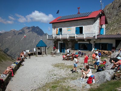
Rifugio Morelli Buzzi
The Morelli-Buzzi refuge is a structure built by the Cai of Cuneo in 1931, enlarged in 2000 and completely modernized in three phases between 2010 and 2012.
It is located in the enchanting Vallone di Lourousa at 2351m above sea level, in the heart of the Maritime Alps Park, at the foot of the north face of Monte Stella, the highest in the Maritime Alps.