The Questa Refuge and the Valscura circle
6 points of interest
Il Lariceto - Cati Caballo  Flora
FloraThe larch
This type of forest is rather localized in the Maritime Alps, which notoriously represent the realm of the beech forest. It covers the slopes at the heads of the valleys with sparse and luminous populations, sometimes grazed by the herds that have climbed the mountain pastures. Most of the time their purity is not natural, but induced by man: in fact, over the centuries, man has favored this tree species to the detriment of others, such as the stone pine, for example, because they are less favorable for exercising the grazing due to the increased shading of the soil.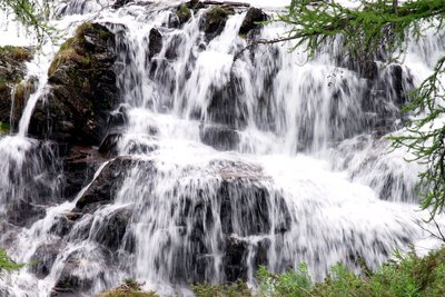
La cascata all'imbocco del Pian del Valasco - Roberto Pockaj  Geology
The Pian del Valasco waterfall
The mass of rocks over which the water falls is a typical example of a glacial rock step. During the glaciations it formed the lower limit of the lake at the foot of the glacier. A tongue of the glacier extended beyond the step.
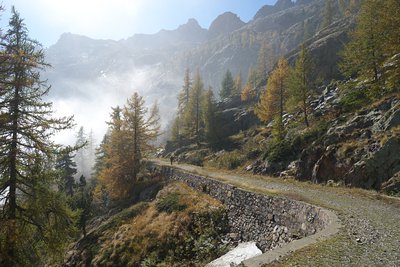
Un tratto della strada ex militare "Pian del Valasco - Lago inferiore di Valscura" - Roberto Pockaj  History and historical trail
Former military road 452
Starting at the fork near the Valasco Refuge, the route follows former military road 452 "Pian del Valasco - Lower Lake Valscura", built in the early thirties to serve the Valscura defense system. In order to make it possible to drive transport vehicles on the road, which was not much more than a wide mule track, much of the 1909 military road had to be expanded, being too narrow to meet the new needs.
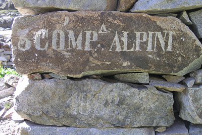
Iscrizione su un cantonale di un ricovero ottocentesco al Lago inferiore di Valscura - Roberto Pockaj History and historical trailThe Valscura Barracks
Since the end of the eighteen hundreds(an inscription on the remains of a shelter reads "3° Compagnia Alpini, 1888") Lower Lake Valscura was chosen as the site where troops were garrisoned to defend the strategic pass of Bassa del Druos. Beginning in 1888, when barracks were erected to house 140 soldiers and two officers, for almost fifty years buildings were constructed on this site, until the entire complex was finally transformed into an armory, officially known as A131,containing munitions, explosives and artillery pieces.
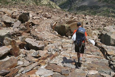
Il tratto lastricato della strada di arroccamento che collega Valscura a Fremamorta - Roberto Pockaj History and historical trailThe former military mule track "Valscura Barracks - Fremamorta Shelters"
The portion of the route that runs from Lower Lake Valscura to Lake Claus follows the former military mule track that linked Valscura and Fremamorta. The mule track is one of the best-preserved examples of the old military roads that ran through the Valle Gesso, as well as a true masterpiece of engineering. Realized sometime around the very first years of the nineteen hundreds, a decade prior to the start of the second world war, in 1929, it was preventively upgraded by the Dronero Battalion and maintained in perfect condition.
Over 10 km long, it never dips below an altitude of 2,000 meters and has a maximum incline of 18%. Portions of the road were skillfully paved with flagstones, still in place today.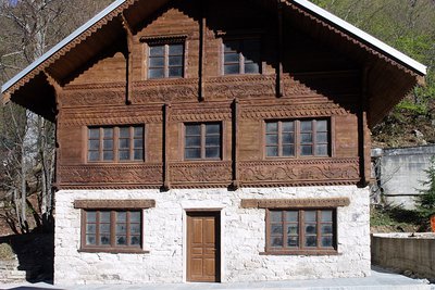
Lo chalet della "Bela Rosin" a Terme - Roberto Pockaj History and historical trailThe 'Bela Rosin' and the Terme chalets
Near the Hotel Royal one can admire two of the four Swiss-style chalets built in Terme in the XIX century and recently restored. Under the roof of one of them, known as the 'Bela Rosin' chalet, there is a date carved - 1857 - corresponding to the year of the institution of the Royal Hunting Reserve of Entracque and Valdieri.
Rosa Vercellana, or 'Bela Rosin', married Vittorio Emanuele II according to morganatic ritual in 1869, and the couple was married by secular authorities in Rome, in 1877, a few months before the King's death. She never held the title of Queen.
Description
The route begins beside the entrance to the parking lot above Terme di Valdieri (1385 m) and follows the unpaved former military road that leads up to Pian del Valasco, similarly to the "Pian del Valasco and the Valasco Refuge" itinerary {->09}. When the dirt road forks (1763 m, 1 hour and 10 minutes from Terme), instead of taking the left fork for the Valasco Refuge, the route continues to the right.
The road reaches the upper Pian del Valasco, passes the turnoff on the left for Colletto del Valasco and climbs uphill, with switchbacks that wind through a sparse patch of larches. Near an enormous larch, the path leaves the road on the left, heading for the Questa Refuge.
The trail rises steeply for a long tract and reaches a wider ex military mule track; after following it for a few meters, the trail leads off to the left.
Passing by the turnoff for Lake Claus on the right, the trail comes to the Questa Refuge (2388 m, 2 hours and 10 minutes from Pian del Valasco).
Returning to the nearest fork, hikers take the left turnoff for Lake Claus. After an up and down portion, the trail again links up with the ex military mule track seen before; following it to the left, hikers walk along the banks of Lake Claus (2339 m) and then cross a wide detritic valley on an incredible flagstoned tract and follow the path downhill to Lower Lake Valscura (2265 m, 50 minutes from the Questa Refuge).
Near the lake, the trail joins an ex military road, following it to the right. Passing the turnoff on the left for Colle di Valmiana, the road proceeds along the bottom of a small, narrow valley and runs through a spectacular tunnel dug in the rock.
The road continues downhill, passing by the foot of a waterfall, and reaches the turnoff for the Questa Refuge, taken on the way up.
Following the same route as at the start, the road returns to Pian del Valasco and then to Terme di Valdieri (1385 m, 2 hours and 25 minutes from Lower Lake Valscura).
- Departure : Terme di Valdieri (1385 m)
- Arrival : Questa Refuge (2389 m)
- Towns crossed : Valdieri
Altimetric profile
Recommandations
Transport
SNCF line TER Provence Alpes-Côte d'Azur For travel in the PACA region and towards Cuneo www.ter-sncf.com/pac
Trenitalia for travel in the Piedmont region https://www.trenitalia.com/it.html
Access and parking
Parking :
Report a problem or an error
If you have found an error on this page or if you have noticed any problems during your hike, please report them to us here:
Close by3
- Mountain Hut
Mountain Hut
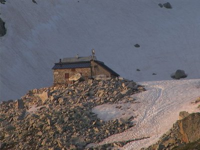
Rifugio Questa
The Emilio Questa refuge (2388 m) stands on a rocky peak located on the north shore of Lac des Portette, in the heart of a vast valley surrounded by the peaks of Portette, Claus and Prefouns. It is an ideal place for naturalist excursions: you can see chamois, ibexes, marmots and the emblematic bearded vulture.
- Mountain Hut
Mountain Hut
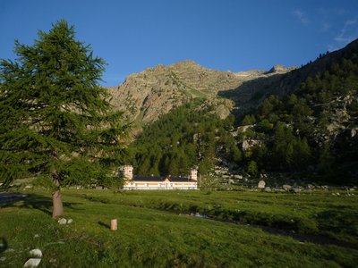
Rifugio Valasco
At the center of the Valasco plateau stands the beautiful Palazzina Reale di Caccia, commissioned by Vittorio Emanuele II for his chamois hunting and for some years now it has become an accommodation facility.
The Valasco Refuge, in the heart of the Alpi Marittime Park, stands at 1764 m in Valle Gesso, Terme di Valdieri (CN). - Mountain Hut
Mountain Hut
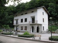
Rifugio posto tappa Gta "Savoia"
The Casa Savoia refuge (GTA stopover) is located in Terme di Valdieri, in the heart of the spa area, at 1,368 meters above sea level. It is located along the itinerary of the Great Crossing of the Alps and is the starting point of numerous excursion itineraries.