
Démant circuit
5 points of interest
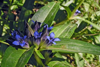
Gentiane croisette, (Gentiana cruciata) - MARTIN-DHERMONT Laurent  Flora
FloraStar gentian (Gentiana cruciata)
Around the hamlet of La Colle, you may be lucky enough to find some star gentian (Gentiana cruciata). This is an herbaceous plant which grows in clumps; it has erect stalks, large, pointed leaves and blue flowers with 4 petals, which are grouped under the upper leaves. This gentian serves as a “nest” for the mountain Alcon blue butterfly (Maculinea rebeli): in this picture, you can distinctly see the eggs laid by the insect.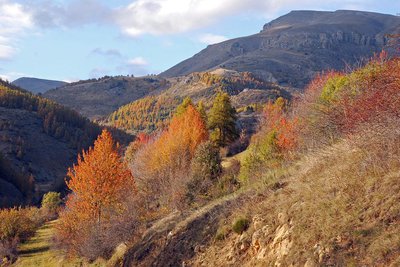
Beuil feuillus et mélézin en allant vers le plateau du Démant, couleurs d'automne. - COSSA Jean-Louis  History and historical trail
Reading the landscape
To understand this landscape, one needs to go beyond the appearance and look carefully at it to spot the clues pointing at agricultural life which, throughout the centuries, shaped it. Meadows scattered with fruit trees, barns, pastoral huts and ruins of military camps are so many visual traces of the activities of the past.
During the Napoleonic period, many owners shared the irrigated meadows as well as the cultivated land. Little by little, cultivation was abandoned in favour of pasture.
In 1954, the Robion family from Beuil still came to cut the hay. And then, pastoralism went into decline. Pasture zones were gradually taken over by broom and, in places, trees such as Scotch pine or larch blocked the access to the former military camp.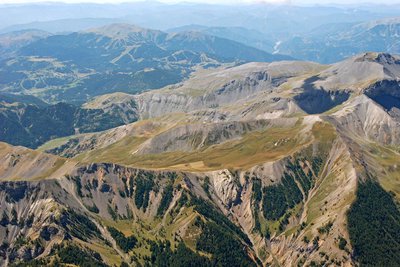
Mont Mounier, (2817 m) - Isola - GOURON Claude History and historical trailA mountain desert
In 1467, under pressure from the community, Count Grimaldi of Beuil accorded the right for people to cut down trees on the mountains of Mounier described at the time as "Alpes" (pastures), proving that the forest was present there.
In 1624, the Duke of Savoie has the trees cleared from the last spinneys on Mounier to build galleys in the port of Villefranche.
Today, the few thousand transhumant sheep maintain this desert-like landscape. Yet in place, small larch trees are trying to establish themselves. Let us bet that studies carried out on the pastures by the Park alongside the shepherds will improve the situation from the point of view of protecting nature.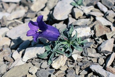
Une campanule d'allioni, (Campanula allionii), poussant sur des éboulis fins. - MALAFOSSE Jean-Pierre FloraThe invaluable flowers
Barely have you gone over the limestone bar with its scents of lavender and broom before you are in the Alps. At this altitude, flowers adapt to survive, becoming perennial, stunted, colourful and strong smelling. Among the species present, Berardia Lanuginosa and alpine bellflower are endemic to the southern Alps and are protected by the law. In the world of plants, the flower is the mist elaborate reproductive organ that nature as created. How could you not respect that!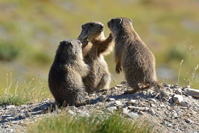
Marmotte des Alpes, (Marmota marmota), conciliabule de marmottons en été ! - BLANC Jacques  Fauna
FaunaObserving marmots (Marmotta marmotta)
If you want to observe marmots, in the valley below the path which runs alongside the agricultural terraces, you will need to be quiet, attentive and position yourself upwind, then look in the meadows for the holes they make, with fresh earth around them and linked by a network of tracks. With the help of a pair of binoculars, you will have no problem spotting same marmots and their young eating, playing or sunning themselves.
A long, repeated call signifies that an unfamiliar presence has been detected (very probably you). A single sharp call means that the golden eagle is around, looking for its favourite prey. In this case, they all dash off to their burrows!
Description
At the Park information boards, follow the dirt track which leads to La Colle along the mountainside.
After the first houses, at marker 8, take the Mont Mounier itinerary which skirts around the houses, heading alongside the drinking trough and then the old sheep dips. A wide path rises, touching on the agricultural terraces. At marker 44, you will be able to appreciate the panoramic view over Beuil and Valberg.
You will reach a first flatter, grassy section, followed by another flatter section and then reach the heart of the Park. Go over the ridge of Les Passes.
At marker 47, another stop will be required to enjoy the panorama to the east of the Mercantour mountain chain and the direct view onto the ruined observatory.
Head right, taking GR5 on the slopes of La Tinée. The path runs alongside the eroded slopes until Col des Moulinés, providing a view of the hamlet of Vignols and the Longon plateau.
Head downwards onto the southern slopes towards the springs at Cians and at marker 45 you will reach the military track. Then follow directions to Col de l’Espaul until you reach the pastoral hut.
A narrow footpath shortcutting the zigzagging path heads to the valley of Les Isclas and the former military camp around the barn.
A 3km return journey via the path to Col de l’Espaul.
- Departure : Col de l'Espaul, Valberg (commune of Péone)
- Arrival : Col de l'Espaul, Valberg (commune of Péone)
- Towns crossed : Péone and Beuil
Altimetric profile
Recommandations
A hike which is exposed to the elements with no opportunities for filling water bottle along the way. Make sure that you take a hat and a full drinking bottle.
A more strenuous variation is available when you reach marker 47 towards the peak of Mont Mounier (2817m) by turning left onto GR5. This will take two extra hours and includes another 300m climbing.Information desks
Office du tourisme de Beuil
1 rue du Comté de Beuil, 06470 Beuil
Access and parking
Parking :
Accessibility
- Emergency number :
- 114
Report a problem or an error
If you have found an error on this page or if you have noticed any problems during your hike, please report them to us here: