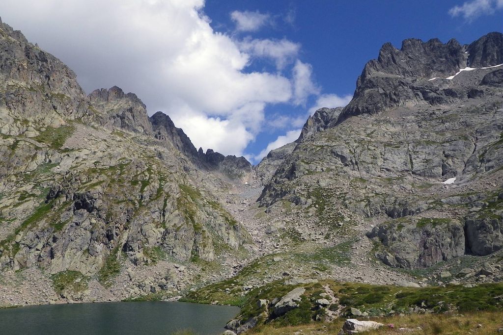
Lake Autier
5 points of interest
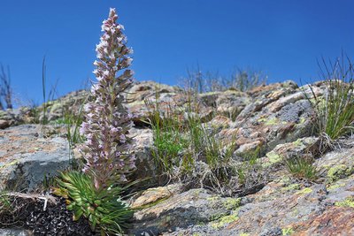
Saxifraga florulenta - P. Pierini  Flora
FloraSaxifraga florentula
Until 1990, the National Park adopted this rare and beautiful flower which grows in the Argentera-Mercantour mountains as an emblem.
This superb rosette of leaves grows on cliffs and in crevices and only flowers once, at the end of its lifespan which lasts from 10 to 70 years.
This flower, endemic to the park, is classified as a protected species, helping protect it from extinction.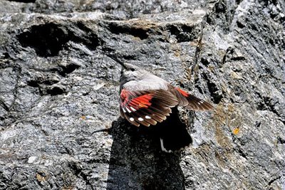
Tichodrome échelette, (Tichodroma muraria). Famille : Tichodromadidés. - BLANC Jacques  Fauna
FaunaWallcreeper (Tichodroma muraria)
Recognisable thanks to the carmine red of its wings, which can clearly be seen when it is flying, this small bird looks for insects and their larvae, fluttering and hopping around the cracks in rocks. Its flight pattern is like that of a butterfly.
This mountain bird only rarely goes into the valley, in winter alone.
It builds its nest in cavity with moss, lichen and twigs. It lays its eggs between May and June. The 3 to 5 eggs are hatched by the female after around three weeks and the young fledge after around three further weeks.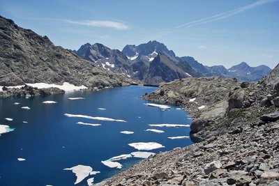
Le lac Autier, (2275 m), et la Baisse Autier, (2637 m). A droite, les crêtes de Muffié. - GUIGO Franck  Lake
LakeMountain lakes
They are numerous in Vésubie (twenty or so) and these lakes were formed around 10000 years ago. They occupy depressions created by the glaciers or the front of the moraine barriers they left behind as they shrank. Despite the fact that they are covered in ice for many months, they are home to invertebrate populations, molluscs, crustaceans, insects. The presence of fish (mainly trout) is due to human intervention, with the fish having been introduced for sport.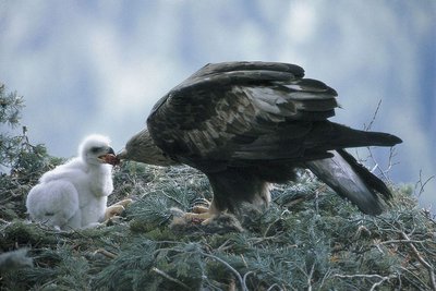
Aigle royal nourrissant son petit au nid, (Aquila chrysaetos). - BLANC Jacques FaunaGolden eagle (Aquila chrysaetos)
A pair of golden eagles frequents the high Gordolasque. This bird lives in the mountain skies, flying over its territory looking for prey to feed to its young. The marmot is the main source of food for golden eagles. In winter, when marmots hibernate, the bird of prey has to largely make do with carrion.
At the start of spring, the female lays two eggs and takes turn with the males to sit on them (43 to 45 days).
During the first weeks, one eaglet can deliberately prevent the other from eating. This aggressive behaviour is known as “siblicide”. The young eagles leave the nest after 65 to 70 days, but remain dependent for three more months.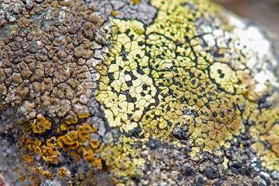
Lichens : Rhizocarpon gr. geographicum (détermination au niveau spécifique seulement par examen des spores) - GUIGO Franck FloraLichens
These primitive organisms are the result of an association between a fungus and algae. Some can be spotted due to the yellow colour they give to rocks.
Lichens can develop thanks only to nutritious mineral substances in the air and in rainwater. They are good indicators of air pollution as the absorb miniscule quantities of pollutants and store them up.
In the picture below: Rhizocarpon gr. geographicum (specific identification only after examination of spores). Photo: Franck Guigo
Description
From Countet Bridge (marker 411), take the path which runs alongside the Gordolasque mountain stream. On the right, the Grand Capelet (2935m) towers over the valley with its imposing bulk and the Tête du lac Autier (2740m) with its flat summit shows you the way to go.
You will then go past a pile of large blocks which have fallen from the mountain; this is an ideal site for climbers.
At marker 413, note the glacier cliff and its smooth rocks which the mountain stream flows over in waterfalls. Cross the river via the wooden footbridge and climb up the opposite bank. Follow the Autier mountain stream until marker 414, then turn right. The path then fords the mountain stream and heads into the Autier Valley. Just before the last projection, note where the water is extracted to supply the electric plant located down from the carpark at Countet.
Here at last is Autier Lake (2275m), girdled on the left and right by the Cime Niré (2666m), the Tête du lac Autier (2740m), Têtes Nord and Sud du Basto respectively 2794m and 2767m, the Cime de Muffié (2866m) and the Caïre Cabri (2649m). Rhododendrons, blueberry bushes and cranberry bushes are dotted over the grass. Cottongrass can be seen going down to the water’s edge.
Follow the same route for the return journey.- Departure : Countet Bridge
- Arrival : Lake Autier
- Towns crossed : Belvédère
Altimetric profile
Recommandations
Information desks
Maison du Parc national du Mercantour - Saint-Martin-Vésubie
8, Avenue Kellermann - Villa Les Iris, 06450 Saint-Martin-Vésubie
Horaires
Ouvert tous les jours sauf le dimanche du 15 juin au 15 septembre
Office de Tourisme Métropolitain - Bureau d'information de Belvédère
Rue Victor Maurel, 06450 Belvédère
Horaires
Ouvert toute l'annéeOffice de Tourisme Métropolitain - Bureau d'information de la Bollène-Vésubie
Place du Général de Gaulle, 06450 La Bollène Vésubie
Horaires
Du 01/01 au 31/12, tous les lundis, mardis, mercredis, jeudis et vendredis de 9h à 17h.Fermetures exceptionnelles les 1er janvier, Lundi de Pâques, Jeudi de l'Ascension, Lundi de Pentecôte, 1er mai, 8 mai, 14 juillet, 15 août, 1er novembre, 11 novembre et 25 décembre.
De 9h00 à 12h00 et de 13h00 à 17h00.
Access and parking
Parking :
Report a problem or an error
If you have found an error on this page or if you have noticed any problems during your hike, please report them to us here: