Le Mont Péla and the hop-hornbeam forest
2 points of interest
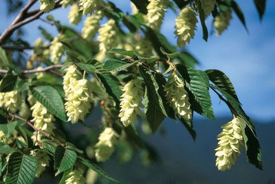
Le charme houblon ou Ostrya ou encore bois-de-fer, (Ostrya carpinifolia), famille des Bétulacées, en fleurs en début d'été - LOMBARD Guy  Flora
FloraHop-hornbeam
The hop-hornbeam is also known as Ostrya. This species, which is characteristic of north-facing, shady slopes, is generally found between altitudes of 300 to 1000m and the only ones which can be found in France in the far south-east of the country due to the tree’s relative tolerance of drought conditions.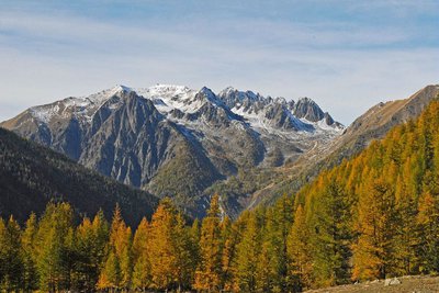
Le mont Saint-Sauveur, (2711 m), saupoudré d'une première neige automnale .Devant ce mont Saint-Sauveur le Caïre Frémus - GUIGO Franck FloraCaÏre de Saint-sauveur
A Caïre de Saint-Sauveur, you will be able to look over the southern slope of the Malagratta valley, with its moorland landscape containing juniper bushes, boxwood, lavender and broom. This habitat, notable for its Mediterranean influence, is grazed by a herd of sheep. It is sometimes subject to controlled burning.
Description
The departure point is at marker 247. The start of the itinerary is along the GR52A (red and white markers). Initially, you will be walking close to the Gordolasque mountain stream. The path then rises through the forest on a north-west facing slope until you reach marker 248.
At the marker, leave GR52A and head left, crossing a flatter grassy section. The path follows a break in the foliage for 300 metres where you can see the former military installations which were part of the Maginot Line then leads onto a small road. Follow this road for a few metres then take the which is on the left.
Enter the hop-hornbeam forest. At around 1250m altitude, then end of this hike is on the crest which separates the north- and the south-facing slopes. The path runs along this crest until it reaches Mont Péla (1465m) via marker 250.
Follow the same route for the return journey.
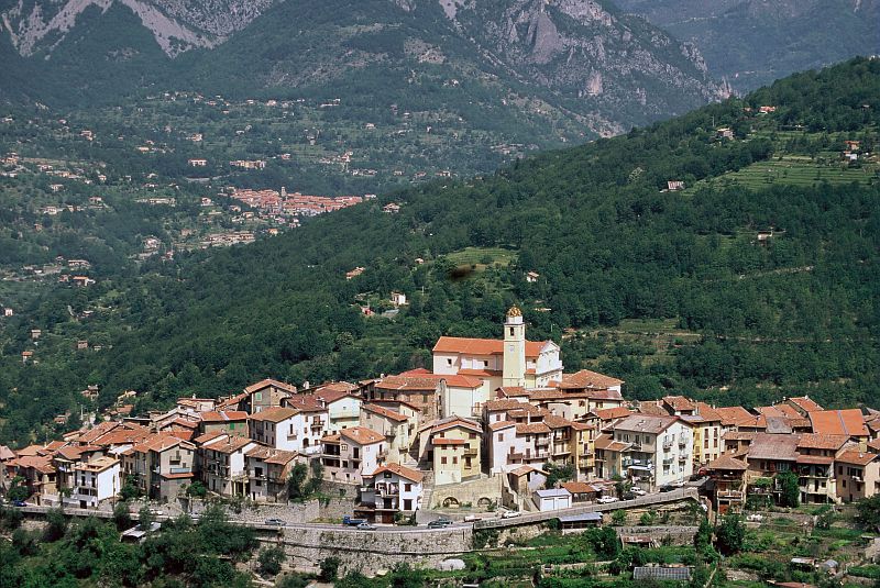
- Departure : Véséou Bridge
- Arrival : Mont Péla
- Towns crossed : Belvédère and La Bollène-Vésubie
Altimetric profile
Recommandations
Information desks
Office de Tourisme Métropolitain - Bureau d'information de Belvédère
Rue Victor Maurel, 06450 Belvédère
Horaires
Ouvert toute l'annéeOffice de Tourisme Métropolitain - Bureau d'information de la Bollène-Vésubie
Place du Général de Gaulle, 06450 La Bollène Vésubie
Horaires
Du 01/01 au 31/12, tous les lundis, mardis, mercredis, jeudis et vendredis de 9h à 17h.Fermetures exceptionnelles les 1er janvier, Lundi de Pâques, Jeudi de l'Ascension, Lundi de Pentecôte, 1er mai, 8 mai, 14 juillet, 15 août, 1er novembre, 11 novembre et 25 décembre.
De 9h00 à 12h00 et de 13h00 à 17h00.
Access and parking
From Saint-Martin de Vésubie, head down the M2565 towards Lantosque. After Roquebillière-le-vieux, go left towards Belvédère (M71). Continue for 650m and at the exit of the first left-hand bend, take the narrow road on the right signposted toward Véséou. Continue on the left at the following junction.
After approximately 1.5 km, you can park near to the bridge or marker 247.Report a problem or an error
If you have found an error on this page or if you have noticed any problems during your hike, please report them to us here: