Amen Circuit
3 points of interest

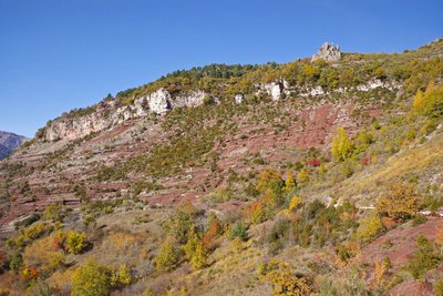
Les couleurs d'automne au dessus des gorges rouges de Daluis, près du hameau de Amen. - Marion BENSA  Flora
FloraDamaged garrigue
It is thus that ecology and vegetation experts defined the vegetation on the southern slope of this valley, due to the destruction of a primitive forest of downy oaks, some of which can be seen alongside the track today. The abandonment of agriculture and the diminution of lad used for pasture in the area have helped the forest regain some ground on this slope. Garrigue is an intermediate form, with bushes such as boxwoods, shadbush and broom. Its golden flowers provide a harmonious contrast in spring with the red of the pelites.
Thyme, lavender and spurge are a reminder that the Mediterranean is close.
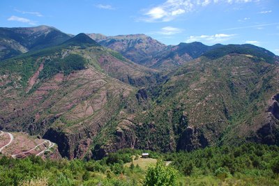
Vue panoramique sur la rive gauche des gorges de Daluis et la clue d'Amen. - Guy LOMBART  Geology
The Daluis Nature Reserve
Founded in 2012, the Regional Nature Reserve of the Daluis Gorges was the first reserve in the department of Alpes Maritimes. Located between the Mercantour National Park and the Mediterranean Sea, it is very interesting in geological, mineralogical, natural and cultural terms.
A majestic gateway between the Provence and the Alps, the nature reserve provides the breath-taking spectacle of the red gorges hollowed out by the Var river, with their giddying pelite cliffs.
Circaète Jean-le-Blanc, (Circaetus gallicus), espèce de rapace spécialisé dans la chasse aux reptiles. - Jean-Claude MALAUSA  Fauna
FaunaShort-toed snake eagle
Beyond the exceptional nature of its landscape, the site of the Daluis gorges also has a wide diversity of flora and fauna, with several plant and animal species which are of interest on a European scale. With a wingspan of around 1.7m, the underside of this snake-eating bird of prey’s wings are white with thin black stripes; it is estimated that a family of short-toed snake eagles (2 adults and a single juvenile) eat five serpents per day. A migratory species, it comes to reproduce in these mountains at the end of March, tirelessly flying over moor and scree seeking out an adder or a grass snake.
Description
From the carpark, cross the D2202 and head along the left bank of the Var, on the little Tireboeuf road which leads to the campsite.
The track (CD16) is located immediately on the left and is indicated by marker 111.
Head upwards following the yellow markers and cross the Tireboeuf Valley via a small stone bridge. At the following crossroads (marker 112), leave CD16 and turn left onto the climb towards Amen. Make sure that you do not lose the track as it heads down towards the Amen water gap, through the scrubland.
At marker 113 continue towards Amen. The hamlet is located a few hundred metres further along. Go through the village then head down towards the Amen water gap, indicated by marker 114.
For the return journey to Guillaumes, take the gorge road CD16 which joins up with the itinerary you used on the way up.- Departure : Pont des Roberts, Guillaumes
- Arrival : Pont des Roberts, Guillaumes
- Towns crossed : Guillaumes
Altimetric profile
Recommandations
Make sure that you have plenty of water with you because this path is very exposed and to be avoided on days when it is very hot.
Be aware that part of the itinerary enters into the Daluis Gorge Nature Reserve. Please ensure that you respect the rules applying to this area.For further information: http://www.reserves-naturelles.org/gorges-de-daluis
Information desks
Office du tourisme de Guillaumes
25 Place de Provence, 06470 Guillaumes
Access and parking
Coming from the Daluis Gorges on the D2202, 1.5km after Guillaumes on the small road to Tireboeuf.
Park at the rest area, just after the Pont des Roberts on the left.
Parking :
More information
Report a problem or an error
If you have found an error on this page or if you have noticed any problems during your hike, please report them to us here:
