5. The Wolf Trail - Argentera & Mercantour - Stage 5
3 points of interest
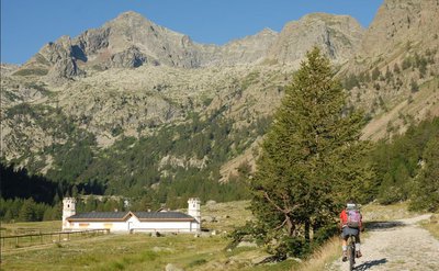
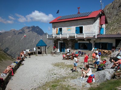
Tête du Claus (2897m), surplombant le refuge de Valasco en été - A. Rivelli / PNAM  History and historical trail
Refugio Valasco, former hunting lodge
This is where King Victor Emmanuel II of Italy had a hunting lodge built, a singular “castle”, square in shape and with a crenelated tower. It has since been transformed into a high-altitude refuge, much to the delight of hikers.
From the Valasco plateau where the refuge is located, you can easily reach the area of the Valascura lakes, heading along the magnificent road built by hunters in the early 20th century. Part of the road is paved, allowing you to go through an area which is littered with boulders and debris.
A mule track leads to the panoramic col of Valmiana.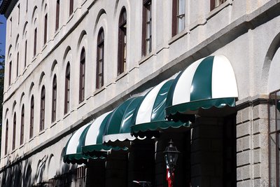
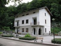
L'Hotel Royal a Terme di Valdieri - Roberto Pockaj  Architecture
The Valdieri Royal Hot Springs
First cited in the mid sixteenth century. When King Carlo Emanuele III decided to valorize the Valdieri hot springs, in 1755, a building and other appurtenances were quickly built in order to create a spa around the sulfurous waters. Cavour called Valdieri "the richest in health-preserving waters in all the nation, and perhaps in all of Europe as well". Vittorio Emanuele II, who first visited Val Gesso in 1855, became a frequent guest at the spa, and it was at his behest that, on 10 July 1857, the first stone was laid for the structure that was to become the Hotel Royal.
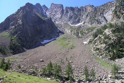
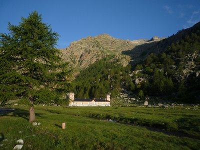
Panorama dai pressi del Lagarot di Lourousa; sullo sfondo al centro il Canalone di Lourousa e, a destra, il Corno Stella - Roberto Pockaj  Lake
LakeThe Lagarot di Lourousa
Springwater, welling up among meadows and larches, forms numerous limpid pools and streams; the water is at times turquoise, at times milky and at others perfectly transparent, making this a particularly striking location, perfect for a contemplative rest. The Canalone di Lourousa, bordered by Monte Stella and the Corno Stella and scoured by the Gelas di Lourousa, lies beyond the plateau of the same name, and a look over one's shoulder yields a view of the imposing outline of Monte Matto.
Description
The itinerary passes along a former military track which was created in the 1930s. From the refuge, cross the plateau and pass close to a waterfall.
The track heads down into the Valasco valley through a fine woodland area with deciduous trees and larches. The entrance to Terme di Valdieri is denoted by the San Giovanni chapel. Head towards the entrance to Terme di Valdieri. You will find the first marker opposite the entrance gate to the spa. Head downhill for a few metres to the left, heading north-east, via the tarmacked road until you reach a carpark. Follow directions for Colle Chiapous via the N8 GTA path with white and red markers which begins on your right. Go over a footbridge (Via Alpina plaque) and head up a long series of hairpin bends along the slopes of the right bank of Vallone di Lourousa (white and red markers). Continue up the hairpins, rising to an altitude of 1855 metres, a climb of 600 metres over a bit more than 4 kilometres! You will reach a flatter section at 2200 metres altitude, close to a mountain stream (with a commemorative cross nearby), at the foot of Canale Lourousa. You will then head downhill for a while until you reach a marker at 1970 metres, where you will continue to the left along the GTA N8 path with white and red markers. At an altitude of 2042 metres, head over a scree for 40 metres. Go up through the screes until you reach the Morelli Buzzi refuge, which is perched on a promontory.- Departure : Valasco refuge
- Arrival : Morelli refuge
- Towns crossed : Valdieri
Altimetric profile
Report a problem or an error
If you have found an error on this page or if you have noticed any problems during your hike, please report them to us here:
Close by3
- Mountain Hut
Mountain Hut
Rifugio Morelli Buzzi
The Morelli-Buzzi refuge is a structure built by the Cai of Cuneo in 1931, enlarged in 2000 and completely modernized in three phases between 2010 and 2012.
It is located in the enchanting Vallone di Lourousa at 2351m above sea level, in the heart of the Maritime Alps Park, at the foot of the north face of Monte Stella, the highest in the Maritime Alps. - Mountain Hut
Mountain Hut
Rifugio Valasco
At the center of the Valasco plateau stands the beautiful Palazzina Reale di Caccia, commissioned by Vittorio Emanuele II for his chamois hunting and for some years now it has become an accommodation facility.
The Valasco Refuge, in the heart of the Alpi Marittime Park, stands at 1764 m in Valle Gesso, Terme di Valdieri (CN). - Mountain Hut
Mountain Hut
Rifugio posto tappa Gta "Savoia"
The Casa Savoia refuge (GTA stopover) is located in Terme di Valdieri, in the heart of the spa area, at 1,368 meters above sea level. It is located along the itinerary of the Great Crossing of the Alps and is the starting point of numerous excursion itineraries.