
The Roccarina Circuit
1 point of interest
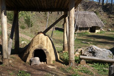
Il Parco archeodidattico della Roccarina - Roberto Pockaj  Archeology
The Roccarina Archeodidactic Park
The archaeological educational park was created to complete and integrate the visit to the archaeological section of the "Giuseppe Avena" Museum. Prehistoric life is illustrated through the reconstruction of the part of a village from the Final Bronze Age (12th-8th century BC) dedicated to manufacturing activities. In this reconstruction we find the shed for metallurgy, a large hut for working metals, bones and horns, a smaller hut for working terracotta, a tub for clay and a furnace for terracotta.
Description
At the northern edge of the clearing where you leave the car (600 m) take the dirt road that goes to the Roccarina Archaeological Park.
Continue along the road heading west, ignore the path on the right signposted for Grangia Certosina (used for the return). The road bends to the right and rises
to merge onto another dirt road. Take the left (on the way back you will use the right branch), until you are still on a dirt road. Go right for a few metres, until
you are at a crossroads: don't take the first dirt road on the right (used for the return), or the dirt road that goes straight ahead; instead take a track, halfway
between the two roads, which goes down into the woods towards Montefallonio.
The track continues for a long time in the woods, then bends sharply to the left, passes a stream and reaches a crossroads, where you keep to the right. A slight
descent leads to the Laghetto Peschiere (578 m, 0:35 mins from the Roccarina Archaeological Park).
After about 150 meters take the path (signposted) on the right that rises with a few bends to reach a small widening, where you follow the dirt road to the left.
The road heads north for a long flat, stretch, then curves to the right continuing on the level; a short descent leads to a wider dirt road that you follow to the
right gaining altitude again. At the first bend, keep right and when the track ends in a clearing, turn left, along a mule track that rises gradually. The mule track
leaves a path in front of it and turns to the right, going up to the Mombrisone Castle (700 m, 0:35 mins from Laghetto Peschiere).
On the opposite side of the hill you go down to a dirt track, which you follow to the left in the woods until it ends where some paths meet.
Take the path to Grangia del Castellar, more or less in front of it: you will lose altitude in the woods and take the dirt road to Cascina Forno.
Follow the dirt road to the left and you will reach a crossroads, where you go back on the outward route, turn left and go on for a few dozen yards, then take
the dirt road that breaks off to the left. When the dirt road forks again, you leave the outward route and carry straight on a dirt track. The track makes a long
semicircle to the right and reaches the hill on which the ruins of the Grangia del Castellar stand (638 m, 0:35 mins from the Mombrisone Castle).
To the east of the grangia a path leads off, it is very clear to start with. The trail goes down into the woods and in a few minutes brings you to the
Archaeological Park of Roccarina and from here back to the starting point (600 m, 0:10 mins from Grangia del Castellar).
- Departure : Parco archeodidattico della Roccarina (600 m)
- Arrival : Parco archeodidattico della Roccarina (600 m)
- Towns crossed : Chiusa di Pesio
Altimetric profile
Access and parking
Report a problem or an error
If you have found an error on this page or if you have noticed any problems during your hike, please report them to us here: