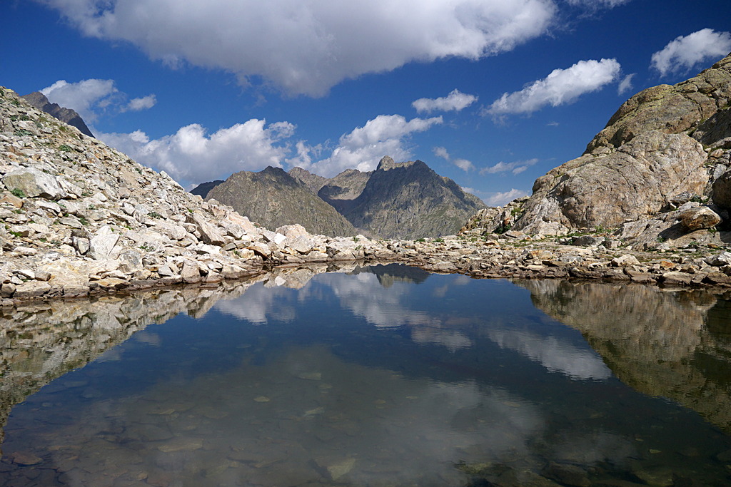
The Colle di Fenestrelle from Lake della Rovina
Besides the Chiotas reservoir, where the route passes through a small grassy meadow, the trek is characterized by the steep grassy slopes and looming rock walls; hikers frequently run into groups of Alpine ibex and chamois near the pass.
2 points of interest

Praterie di alta quota - Cati Caballo  Flora
FloraThe cleared meadows
At the highest altitudes there are cleared meadows, the typical alpine pastures; they are composed of herbaceous species capable of covering soils normally closed to woody species, which, due to the very short vegetative period, cannot find suitable conditions for their development. Grazing by wild ungulates and, sometimes, by domestic sheep affects their composition, even if the most severe factor for species selection is represented by the climate.
Giovani stambecchi al Colle di Fenestrelle - Roberto Pockaj  FaunaColle di Fenestrelle, as well as the surrounding area, is very popular with the ibex.
The Alpine ibex (Capra ibex), frequents alpine meadows and rock faces even above 3000 m, reaching the valley floor (provided it is not wooded) only in early spring, to be able to refresh itself after the long winter. Both sexes have annual growth horns, but much larger in males. The coat, light beige in summer, darkens to dark brown in winter.
Sedentary, grazing, it essentially feeds on grass, integrated with mosses, lichens and leaves of mountain shrubs, especially in winter.
Description
The route begins to the left of the small building at the southern end of the developed area of Lake della Rovina (1545 m).
After a few steps, the trail turns right towards the ENEL cabin and then, a bit further to the left, the real trail begins.
The trail rises in a series of switchbacks, then passes over some rocky points with the aid of a few steps. The steep ascent continues for a long stretch, alternating between switchbacks and steps.
Further up, the trail forks: to the left, the old trail surmounts a few rocks thanks to a metal ladder, while the right fork rises above them with a few switchbacks (recommended choice). The trail then arrives at the unpaved road, now unusued, that was used by construction vehicles when the dam was built.
To the left, downhill, the road leads back to Lake della Rovina, following an alternative route, less steep but exposed in parts and passing through an area where rockslides are possible.
The route turns left for a few hundred meters: shortly before the tunnel that passes under the dam's drainage channel, the trail turns left on the unpaved track leading to the Genova Figari Refuge.
The paved road instead continues on to the Chiotas dam, 130 m high, which can be reached in just a few minutes on foot. The walkway on top of the dam, the only access to the Vallone del Chiapous on foot, is open to hikers and is decidedly worth crossing over.
After leaving the paved road, the route follows the dirt road uphill on a fairly steep gradient, at first beside the drainage channel, until it reaches the Colle di Laura dam (1980 m, 1 hour and 15 minutes from Lake della Rovina), from which there is a fine view of the Chiotas reservoir.
An extended up and down stretch runs along the southeast perimeter of the reservoir, passing by the turnoff on the left for Colle di Fenestrelle. The trail leads up the little grassy plateau just above the road, passes through it and climbs up a few dozen meters to a second flat meadow, next to a stream (may be muddy or swampy in places). It then leads to the left(on the orographic right of the Vallone del Fenestrelle - both valleys that lead up to the Colle bear the same name) and, with many switchbacks, climbs up again, at first on a grassy slope and then over detritic terrain. A short traverse leads to the foot of some rocky outcroppings rubbed smooth by glacial action, which the trail surmounts in a series of tight switchbacks.
Past the outcroppings the trail descends for a few meters and then begins to climb once more, amidst rocks, rubble and sparse clumps of grass. For a short tract, the trail snakes among the rocks, passing by the turnoff for a difficult trail on the left and then descending again in a series of turns. It then crosses a detritus-filled depression (there may be snow here even in early summer) and moves to the orographic left of the valley.
A final series of switchbacks leads to a lengthened valley ending at Colle di Fenestrelle (2462 m, 1 hour and 45 minutes from the Chiotas dam reservoir).
We advise excursionists to descend from the Colle to the tiny grassy meadow just below it and then cross to the opposite side (a decidedly more comfortable place to rest), near the ruins of a nineteeenth century shelter.
- Departure : Developed area at Lake della Rovina (1545 m)
- Arrival : Colle di Fenestrelle (2462 m)
- Towns crossed : Entracque
Altimetric profile
Recommandations
Transport
SNCF line TER Provence Alpes-Côte d'Azur For travel in the PACA region and towards Cuneo www.ter-sncf.com/pac
Trenitalia for travel in the Piedmont region https://www.trenitalia.com/it.html
Access and parking
From Borgo San Dalmazzo go up the Valle Gesso. After Valdieri, turn left towards Entracque. Before the village, turn right for San Giacomo, then follow the signs to the right for Lago della Rovina. Paid parking in the summer season.
Parking :
Report a problem or an error
If you have found an error on this page or if you have noticed any problems during your hike, please report them to us here: