The Lagarot di Lourousa
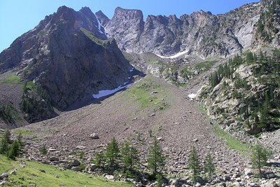
Splendid beech and conifer woods flank the trail as it climbs, almost as far as the Lagarot. In the limpid pools of water one can see the reflection of the rock faces of Monte Matto. Chamois are often seen in both the woods and the ample, grass-covered basin.
1 point of interest
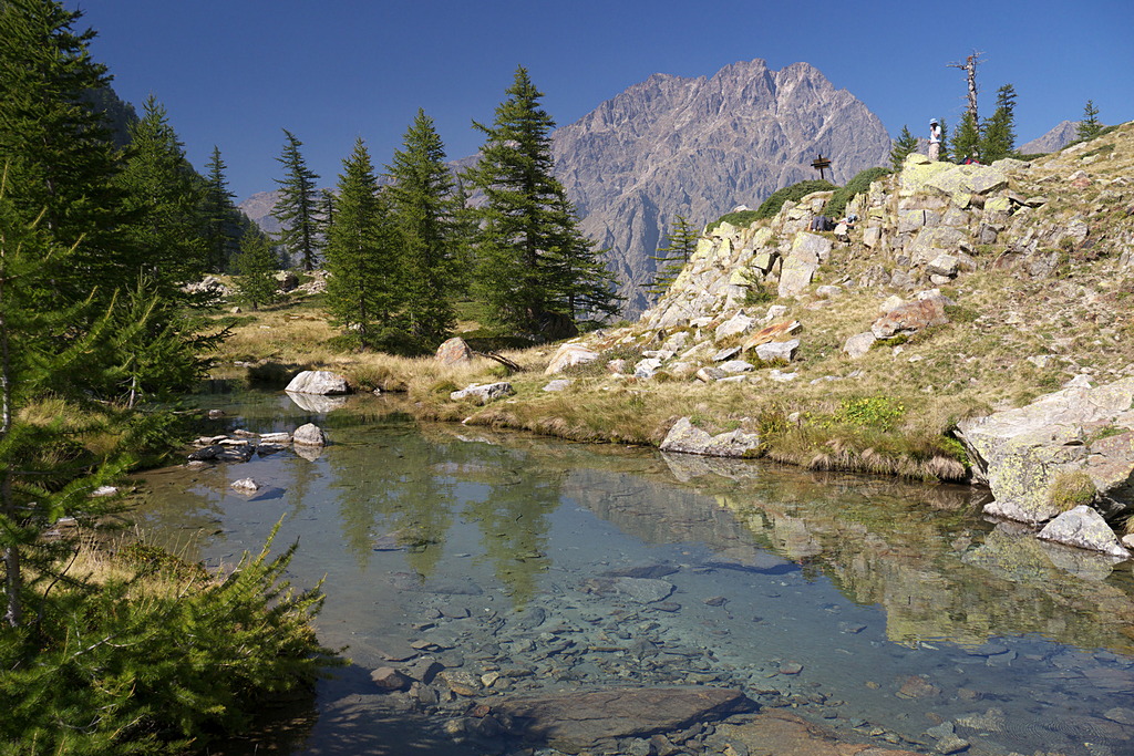
Panorama dai pressi del Lagarot di Lourousa; sullo sfondo al centro il Canalone di Lourousa e, a destra, il Corno Stella - Roberto Pockaj  Lake
LakeThe Lagarot di Lourousa
Springwater, welling up among meadows and larches, forms numerous limpid pools and streams; the water is at times turquoise, at times milky and at others perfectly transparent, making this a particularly striking location, perfect for a contemplative rest. The Canalone di Lourousa, bordered by Monte Stella and the Corno Stella and scoured by the Gelas di Lourousa, lies beyond the plateau of the same name, and a look over one's shoulder yields a view of the imposing outline of Monte Matto.
Description
Opposite the entrance gate to the driveway of the Hotel Royal in Terme di Valdieri (ca. 1353 m) a brief paved downhill stretch leads down to the large unpaved parking lot. Along this stretch, on the right, the trail begins for the Lagarot di Lourousa and the Morelli Buzzi Refuge.
After a brief tract through the woods, the trail reaches the mouth of the Vallone di Lourousa and crosses over the torrent on a long, narrow wooden walkway.
On the other side of the torrent the route joins a comfortable mule track that rises up the orographic right of the valley, shaded by thick beech and mixed deciduous woods.
There is an infinite series of switchbacks, never excessively steep, as the trail slowly picks up altitude. When the beeches give way to larches and firs, the panorama suddenly appears: to the rear, Monte Matto, to the right, the Vallone del Valasco, directly ahead the pinnacle of Corno Stella and the Canalone di Lourousa.
After a long traverse to the southeast, the trail comes to the Gias Lagarot and passes by it to the right. There larches are decidedly sparser here, and after crossing the plateau, the trail surmounts a hump with a few more switchbacks and, passing by a well-marked turnoff on the right next to a large larch, reaches the bowl of the Lagarot di Lourousa (1971 m, 2 hours and 5 minutes from Terme di Valdieri).
The pretty pools cannot be seen from the trail at this point, but they can be reached in just a few minutes by following the trail downhill to the right.
The abovementioned turnoff to the right of a large larch, on a switchback heading left, passes along the banks of the Lagarot di Lourousa above. The trail is still passable, but it is preferable to continue on the main trail to prevent erosion of the soil. On a large boulder beside this old trail there are the all too many grave markers and a cross in memory of the people who have died during climbs and other mountaineering activities on the Canalone di Lourousa.
- Departure : Terme di Valdieri (1353 m)
- Arrival : Lagarot di Lourousa (1971 m)
- Towns crossed : Valdieri
Altimetric profile
Recommandations
Transport
SNCF line TER Provence Alpes-Côte d'Azur For travel in the PACA region and towards Cuneo www.ter-sncf.com/pac
Trenitalia for travel in the Piedmont region https://www.trenitalia.com/it.html
Access and parking
Drive from Borgo San Dalmazzo up the Valle Gesso. Pass by Valdieri and continue on to Terme. There is a parking fee in the summer season.
Parking :
Report a problem or an error
If you have found an error on this page or if you have noticed any problems during your hike, please report them to us here: