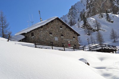
The Livio Bianco Refuge
An initial tract in the woods is followed by a series of warm and sunny grassy slopes. The path goes by many gias, testifying to the activities related to bringing the livestock to the high pastures in the warm months, and the buildings at Chiot della Sella, once used by the Savoys as hunting lodges.
2 points of interest
Il Vallone della Meris - Giorgio Bernardi  History and historical trail
The place name "Vallone della Meris"
The Vallone della Meris (or, in the masculine, the Vallone del Merìs, pronounced with an accent on the 'i', differently from the normal pronunciation) owes its name to its favorable exposure,"a meriggio", at the meridian, which provides warmth and light.
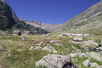
Il Chiot della Sella - Roberto Pockaj History and historical trailThe place name "Chiot de la Sela"
This place, known as Chiot de la Sela, probably dervied its name from the past presence of a small "sella", a stone structure with a barrel vault, usually partially underground, which was used to store food). Chiot de la Sela was the location of the Royal Hunting Lodges, used by the Savoys when they hosted hunting parties in the Vallone della Meris.
Description
From the uphill end of the village of Sant'Anna di Valdieri (980 m), a paved path rises rapidly among the houses, passing beside the Locanda Alpina Balma Meris. A steep mule track climbs into the woods of mixed deciduous trees: proceeding past the fork leading to Tetti Bariau ("Lo Viol di Tàit"), the trail veers westward for a brief tract, and rises less steeply. It passes by the ruins of Tetti Bìaìsa and continues to climb, with overhead views of the Rio della Meris, which forms crystal-clear pools in this area.
A few switchbacks and long traverses lead to a cool beech forest and the few remaining traces of Tetti Paladin.
Less steeply now, the path continues on out of the woods; at an altitude of ca. 1380 m the path passes a shortcut on the left, which joins back up with the mule track not far ahead, and a not very well marked trail on the right leading to Monte Merqua. The path continues monotonously upward, with a long crossing at midslope on the orographic left side of the valley, until it reaches a large flat pasture, with the ruins of Gias del Prato (1513 m, 1 hour and 35 minutes from Sant'Anna di Valdieri) and, a few hundred meters further on, the new Gias del Prato (fountain).
The mule track winds along the bottom of the valley, among pastures and detritus, flanked a few meters below by a small path which it joins farther on. After another long tract the valley narrows where the Rio della Meris has cut most deeply into the valley floor. Passing by a mule track on the left that descends to a ford in the river, the path enters the pasture meadow of the Gias del Chiot della Sella, where a Park Service station is situated.
Beyond the Gias, the mule track climbs more steeply, and after passing a brook there is a view of the lovely waterfall formed by the runoff from Upper Lake Sella. The trail forks when it reaches the Gias del Lago: the route abandons the mule track, which continues on to Lake Sella, and crosses over Rio della Meris on a wooden bridge. A good path runs around the shore of Lower Lake Sella (1862 m, 1 hour and 15 minutes from the Gias del Prato), which in just a few minutes leads to the Livio Bianco Refuge(1890 m, 5 minutes from Lake Sella), located in a perfect spot beside the water.
- Departure : Sant'Anna di Valdieri (980 m)
- Arrival : Livio Bianco Climbers' Hut (1890 m)
- Towns crossed : Valdieri
Altimetric profile
Recommandations
Transport
SNCF line TER Provence Alpes-Côte d'Azur For travel in the PACA region and towards Cuneo www.ter-sncf.com/pac
Trenitalia for travel in the Piedmont region https://www.trenitalia.com/it.html
Access and parking
Parking :
Report a problem or an error
If you have found an error on this page or if you have noticed any problems during your hike, please report them to us here:
Close by3
- Mountain Hut
Mountain Hut
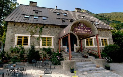
Rifugio Balma Meris 980 m
The Balma Meris Alpine Inn is a small mountain lodge housed in a recently renovated stone building.
The lodge is located in the center of the village of Sant'Anna, a typical mountain settlement nestled along the Gesso Stream at the confluence of the Meris Valley. Sant'Anna is the only permanently inhabited village within the Maritime Alps Regional Nature Park.