Lakes circuit
8 points of interest
La Serpentine est le nom donné au torrent du Chadoulin, (affluent du Verdon), sur le haut de son cours, sur le plateau du Laus - Le Bouteiller Éric  Flora
FloraSecrets of the peat bog
This vast grassy expanse is one of the finest peat bogs in the Mercantour.
Peat bogs are rich in information: its depth is more than 8 metres. The succession of layers contains precious clues (grains of pollen, plant debris, etc…). They allow scientists to date things back as far as 9500 years ago.
These wetland areas which have little oxygen but plenty of nitrogen are home to flora adapted to the environment, namely bog plants: sphagnum moss, cotton grass with its gracious white cotton toupee as well as Alpine butterwort, one of the carnivorous plant species which can be found in France.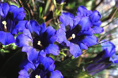
Gentiane de Koch en gros plan, (Gentiana kochiana). - LOMBART Guy FloraFrom one cairn to another
A bare, secretive and fascinating environment: From Pas du Lausson to Col de la Petite Cayolle, these are the high mountains. The décor is rocky and grass is thin on the ground. This is also the stronghold of audacious plants. In order to protect themselves against the hostility of the climate, they are small and perennial, often with large and colourful flowers.
This vegetation which, highly adapted to climatic hardships, is fragile and of exceptional value. Plants which can be found here include the spring gentian, moss campion, glacier crowfoot, the stemless gentian, Alpine toadflax…, but also certain endemic species like Berardia subacaulis and Campanula allionii.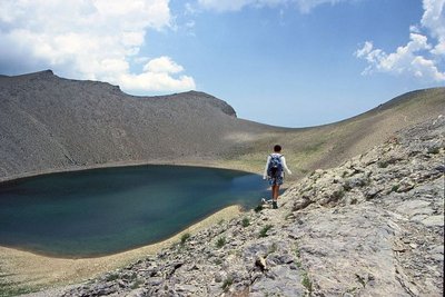
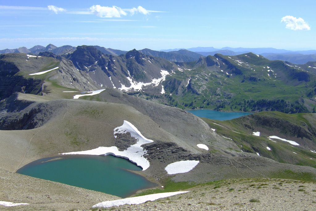
Le lac des Garrets, (2621 m), le Lausson, randonneur. Paysage très minéral. - DEMONTOUX Daniel  Lake
LakeLac des Garrets
The lake incurs the ramifications of its high altitude. The high level of evaporation in the summer sees it shrink, giving it the characteristic shape of a wine glass in autumn. The freezing weather which causes it to “hibernate” for nearly 8 months a year, would appear to prevent life from surviving in it. However, an energy-capturing phytoplankton began developing there, opening the way to life in the mountain lakes.
Here, however, life halted at the plankton stage. The rare organic matter is used by an inactive lifeform. Given that the lake is “cleaned” in this fashion , the waters of this oligotrophic lake are clear, despite it being stagnant.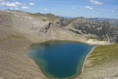
Le lac de la Petite Cayolle en été, dans sa combe minérale, vue plongeante vers le haut-Verdon. - COSSA Jean-Louis LakeLac de la Petite Cayolle
It is a story of long ago, of the great glaciers which, as they slowly but unstoppably moved, shaped the Alps. Their flow hollowed out softer rocks and smoothened the harder ones, ripping any obstacles out of their way.
10000 years ago, the time of the great blanket of ice and snow came to an end and the glacier began shrinking, leaving behind it great hollows and terminal moraines: the glacial lakes found a home there, like Lac de la Petite Cayolle 3000 years ago.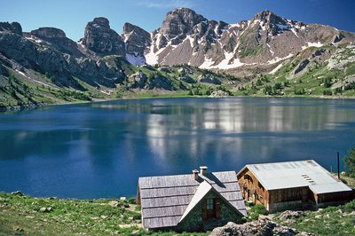
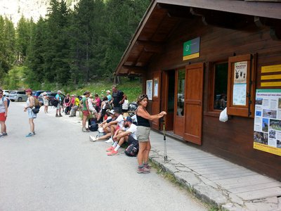
Le lac d'Allos, (2228 m), le refuge des bords du lac, en fond, les Tours du Lac, en début d'été - LAURENT Olivier  Refuge
Lac d'Allos refuge
Refuge managed by the commune of Allos
Refuge-bar-restaurant
Capacity: 40 places
Warden: June to September. Shelter room located just above the refuge, open 365 days per year.
Tel. 04 92 83 00 24
http://refuge-du-lac-dallos.com
Val d’Allos Tourism Office: 04 92 83 02 81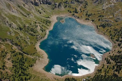
Le lac d'Allos - GOURON Claude LakeLac d'Allos
Created by the glaciers of the quaternary period, Lac d'Allos is the biggest natural lake at this altitude in Europe (62ha). It waters come from the thawing snow as well as from springs, and they reach up to 42m in depth. It burgeons with more life than in the previous lakes: invertebrates, juvenile fish, brown trout and arctic char.
Lac d'Allos is an incredibly fragile environment due to the extreme conditions and the low number of plant and animal species. The arctic trout which exist here are, for reasons which remain unknown, affected by dwarfism. Any pollution or modification of the environment would be disastrous. But the presence of the National Park should today ensure that the lake can live in peace.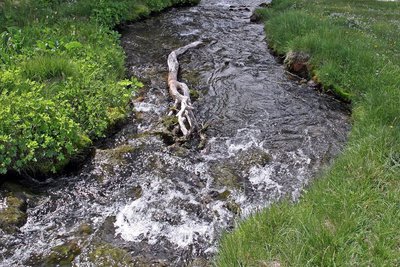
La Serpentine est le nom donné au torrent du Chadoulin, (affluent du Verdon), sur le haut de son cours. - LE BOUTEILLER Eric  Geology
Where is this water coming from?
The beautiful outlet that you see before you is a singular case in hydrogeology: it is unique in the Mercantour and almost so in the Alps! Indeed, this water is escaping from Lac d’Allos which makes it a very rare case of a lake without an overflow and it is even more remarkable when you consider that this is the biggest natural high-altitude lake in Europe whose depth varies from 42 to 49 metres depending on the year.
The spring formed is called Chadoulin, an affluent of the left bank of the Verdon.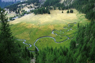
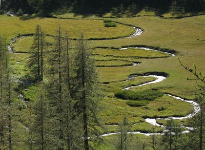
La Serpentine est le nom donné au torrent du Chadoulin, (affluent du Verdon), sur le haut de son cours, sur le plateau du Laus. - CULOTTA Jean-marc GeologyThe grassy plateau of Laus
The grassy plateau of Laus has been a living memory of life for 9000 years. It was created as the glaciers shrank, a lake occupied the site. The fact that it was not very deep, in addition to the floods of sediment and organic matter flowing into it accelerated the process of filling in this lake. The biggest role was played by bryophytes: while their roots decompose, bryophytes keep growing upwards, trapping pollen. Analysing them allows us to retrace the history of existence in the area.
Despite gradually drying out for several thousand years, the process is still ongoing today. This environment is still damp and contains plants which are more readily associated with peat bogs. The winding curves of the Serpentine gleam on this plateau.
Description
Take the path which leads to Lac d'Allos. Just after the wetland area of the Laus plateau, a fork on the left shows the way to the Col de la petite Cayolle. The path rises gently, lightly shaded by a larch forest, whose trees are bent at their base due to the weight of the blanket of snow they often wear.
The path leads to the pastures of the Méouilles plateau and then continues in a series of zigzags before reaching the Lac de la Petite Cayolle.
At the col of the same name, turn right, remaining on the Verdon hillside and reaching Lac des Garrets, which is nestled in rocky surroundings. Go around the lake in a westerly direction and reach the crest of the Lausson summit (2645m), the dividing line between the Var and the Verdon basins. Follow this crest until you reach the Pas du Lausson (2602m).
The path then heads down on the Allos side and then joins the Méouilles plateau via a footpath cut into the rock face on a slope which has no vegetation. The plateau, in contrasting fashion, appears as a haven of peace, a large prairie across which a stream flows and which is scattered with a few larch trees.
Then take the path towards the Lac d'Allos. On its banks, the refuge/hotel is an excellent place to take a break. The lakes sandstone towers provide a delightful backdrop. Follow the path which heads back to the carpark, overlooking the Laus plateau.
- Departure : Carpark at Laus, Allos
- Arrival : Carpark at Laus, Allos
- Towns crossed : Allos, Entraunes, and Uvernet-Fours
Altimetric profile
Recommandations
Information desks
Office du tourisme du Val d'Allos
Place de la coopérative, 04260 Allos
Horaires
Toute l'année.
Fermeture exceptionnelle le 1er mai.
Transport
Free minibus service in Val d'Allos (Transports Haut-Verdon Voyages):
http://ete.valdallos.com/
Tel: 04 92 83 95 81
LER PACA lines to reach Digne-les-Bains,
Barcelonnette and Nice
Tel.: 00 33 (0) 821 202 203
www.info-ler.fr
Departmental bus services in Alpes-de-Haute-Provence Regular/weekly services Digne-les-Bains, Barcelonnette, Larche and Digne-les-Bains, Colmars, Allos, Regional Council Transport Service
Tel: 00 33 (0)4 92 30 08 00
www.cg04.fr
Chemins de Fer de Provence from Nice to Digne-les-Bains
Tel.: 00 33 (0) 4 97 03 80 80
www.trainprovence.com
Access and parking
At Allos, take the RD226 towards Lac d'Allos. The road comes to an end at the carpark, where you can leave your vehicle.
More information on access and parking: https://www.valdallos.com/lac-d-allos.html
Parking :
Report a problem or an error
If you have found an error on this page or if you have noticed any problems during your hike, please report them to us here:
![Vue du refuge, situé sur une butte au milieu de la végétation environnant. Espace de terrasse devant l'entrée principale, [...]](https://adminrando.marittimemercantour.eu/media/paperclip/tourism_touristiccontent/1784/38456026.jpg.400x0_q85.jpg)