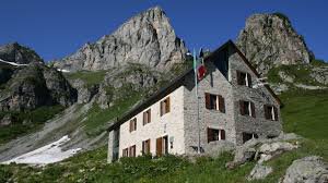
This trail winds through alpine pastures and meadows all the way to Passo delle Saline. It passes through one of the areas that displays the most evident and characteristic signs of karst phenomena, from erosion caused by runoff water on limestone rocks to the various sinkholes that can be seen along the way. The view from Cima delle Saline is also excellent.
Description
From Porta di Pian Marchisio (or Pian Marchisa, 1634 m), follow the dirt road that descends into the wide pasture plain of Pian Marchisio and continues for a long stretch on level ground alongside the Ellero Stream.
With two hairpin turns (bypassed on the left by short shortcuts), the dirt road gains elevation, passes the trail on the right that leads directly to the mountain hut and a farm-pastoral track, and then forks.
Take the left fork, crossing the stream over a concrete bridge.
The dirt road continues on level ground and then fords the stream flowing at the bottom of the valley twice.
Just past Gias Pra Canton, the dirt road climbs a rocky outcrop with a couple of turns and reaches the junction on the right with the trail to Passo delle Saline.
Take the trail that continues up the rocky outcrop through a sort of gully and emerges onto the plateau above, near the ruins of a mountain pasture and the Inghiottitoio del Tumpi.
A trail through the meadows (marked by trail markers) runs alongside a long, nearly straight rocky outcrop; after keeping it on your left, you climb up it until you return to wide alpine meadows (the effects of limestone erosion on the exposed rocks are clearly visible along this section of the trail).
The trail (still marked by trail markers) turns to the right and climbs the slope, first with a few switchbacks, then with a steep traverse. A flat section leads further to the right (southwest), crossing a wide grassy basin to the foot of the Passo delle Saline.
The start of the final slope is steep, partly due to ill-advised shortcuts; only in the final part of the ascent do easier switchbacks reappear, leading up to the Passo delle Saline (2177 m, 2 hours and 15 minutes from the Porta di Pian Marchisio).
At the pass, take the trail that branches off to the right. Soon, the trail becomes a narrow path that climbs extremely steeply with very tight switchbacks, staying fairly close to the watershed at all times. The path, which is almost always visible, climbs for a long stretch up the slope through fine debris and small rocks until it reaches the base of a clearly visible rocky outcrop that seems to block the way. Instead, by veering slightly to the left, you can follow a sort of wide ledge that allows you to climb the final few dozen meters of elevation gain separating you from the summit of Cima delle Saline (2613 m, 1 hour and 05 minutes from Passo delle Saline).
- Towns crossed : Briga Alta
Altimetric profile
Access and parking
From Villanova Mondovì, drive up the Ellero Valley to Roccaforte Mondovì. Then turn left toward Rastello, where you’ll take the “Pian Marchisio forest road.” The road climbs for over 4 km, partly paved and partly unpaved (vehicles with high ground clearance are recommended), until you reach the Porta di Pian Marchisio.
Report a problem or an error
If you have found an error on this page or if you have noticed any problems during your hike, please report them to us here: